Kampilo keeps all photo attribution in this single directory. Local copies are optimized for the site; ownership and licenses remain with their credited creators.
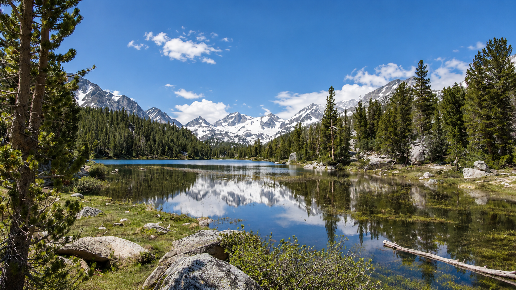
Homepage heroAlpine lake reflecting snow-streaked Sierra peaks beneath a bright blue skyUser-supplied alpine lake image
Image supplied by the site owner · Provided for use on Kampilo
Original fileLittle Lakes Valley card · Little Lakes Valley gallery · Mosquito Flat TrailheadLittle Lakes Valley trail crossing an alpine meadow below Sierra peaks
Anthony Greco · CC BY 2.0
Original sourceLittle Lakes Valley gallery · Little Lakes Valley camp map · Little Lakes Valley route map · Long Lake camp areaLong Lake beneath granite peaks in Little Lakes Valley
TracyElaine · CC BY 2.0
Original sourceLittle Lakes Valley gallery · Little Lakes Valley camp map · Little Lakes Valley route map · Gem Lakes camp areaAlpine lake and peaks along the Little Lakes Valley trail
Hike395 · CC BY 3.0
Original sourceLittle Lakes Valley galleryLittle Lakes Valley seen above Mack Lake with water, forest, and granite peaks
Jane S. Richardson · CC BY-SA 3.0
Original sourceLittle Lakes Valley camp map · Little Lakes Valley route map · Chickenfoot Lake camp areaMount Dade rising above Chickenfoot Lake in Little Lakes Valley
Mount Dade from Chickenfoot Lake — David Phillips, CC BY 2.0
Original sourceGrand Canyon Rim to Rim card · Grand Canyon Rim to Rim galleryRibbon Falls along the North Kaibab corridor in Grand Canyon
Grand Canyon National Park · CC BY 2.0
Original sourceGrand Canyon Rim to Rim gallery · Grand Canyon Rim to Rim camp map · Grand Canyon Rim to Rim route map · Cottonwood CampgroundNorth Kaibab Trail descending through the upper Grand Canyon
Grand Canyon National Park · CC BY 2.0
Original sourceGrand Canyon Rim to Rim gallery · Grand Canyon Rim to Rim camp map · Grand Canyon Rim to Rim route map · Bright Angel CampgroundBright Angel Creek flowing through the shaded campground corridor
NPS video still · U.S. government public domain
Original sourceGrand Canyon Rim to Rim gallery · Grand Canyon Rim to Rim camp map · Grand Canyon Rim to Rim route map · Havasupai Gardens CampgroundThe green cottonwood grove of Havasupai Gardens below Grand Canyon walls
Grand Canyon National Park · Public domain
Original sourceEnchanted Valley card · Enchanted Valley galleryEnchanted Valley and its historic chalet beneath Olympic mountain walls
Fduchossois · CC BY-SA 4.0
Original sourceEnchanted Valley gallery · Enchanted Valley camp map · Enchanted Valley route map · O'Neil Creek CampOld-growth trees in the Quinault Rainforest
Olympic National Park · Public domain
Original sourceEnchanted Valley gallery · Enchanted Valley camp map · Enchanted Valley route map · Enchanted Valley CampWaterfalls descending the forested mountain walls above Enchanted Valley
Ryan Snyder · CC BY 2.0
Original sourceEnchanted Valley galleryThe historic chalet in Enchanted Valley beneath forested mountain walls
Ryan Snyder · CC BY 2.0
Original sourceJumbo Rocks Camp cardJumbo Rocks Camp landscape
Joshua Tree National Park · Public domain
Original sourceJumbo Rocks Camp gallery · Jumbo Rocks CampgroundRounded monzogranite formations surrounding Jumbo Rocks CampgroundJumbo Rocks Campground - 1
Robb Hannawacker / Joshua Tree National Park · Public domain · License
Original sourceJumbo Rocks Camp gallery · Jumbo Rocks CampgroundClose view of weathered granite at Jumbo Rocks CampgroundJumbo Rocks Campground - 2
Robb Hannawacker / Joshua Tree National Park · Public domain · License
Original sourceJumbo Rocks Camp gallery · Jumbo Rocks CampgroundCampground facilities tucked among the boulders at Jumbo RocksJumbo Rocks Campground in Joshua Tree National Park - 01
Joshua Tree National Park · Public domain · License
Original sourceJumbo Rocks Camp gallery · Jumbo Rocks CampgroundPicnic table and grill at a Jumbo Rocks campsiteJumbo Rocks Campground in Joshua Tree National Park - 03
Joshua Tree National Park · Public domain · License
Original sourceJumbo Rocks Camp gallery · Jumbo Rocks CampgroundCamper trailer beneath the rocks at Jumbo Rocks CampgroundCamper trailer at Jumbo Rocks Campground
Joshua Tree National Park · Public domain · License
Original sourceJumbo Rocks Camp destination archive · Skull RockThe skull-shaped granite formation beside the Skull Rock trail
Alexander Migl · CC BY-SA 4.0
Original sourceJumbo Rocks Camp destination archive · Barker DamBarker Dam holding water between Joshua Tree rock formations
King of Hearts · CC BY-SA 3.0
Original sourceJumbo Rocks Camp destination archive · Keys ViewPink evening light over the Coachella Valley from Keys View
King of Hearts · CC BY-SA 3.0
Original sourceUpper Pines Base Camp cardUpper Pines Base Camp landscape
Andrew Burnham · CC BY-SA 3.0
Original sourceUpper Pines Base Camp gallery · Upper Pines CampgroundForest and creek-edge vegetation at Upper Pines CampgroundYosemite - Upper Pines Campground
Andrew Burnham · CC BY-SA 3.0 · License
Original sourceUpper Pines Base Camp gallery · Upper Pines CampgroundBear-resistant food locker at an Upper Pines campsiteBear-resistant container 3
Mx. Granger · CC0 1.0 · License
Original sourceUpper Pines Base Camp gallery · Upper Pines CampgroundPropane-canister recycling station among Upper Pines treesPropane canister recycling
Mx. Granger · CC0 1.0 · License
Original sourceUpper Pines Base Camp destination archive · Vernal Fall FootbridgeVernal Fall dropping over a granite cliff above the Mist Trail
Hannes Flo · CC BY 2.0
Original sourceUpper Pines Base Camp destination archive · Mirror LakeMirror Lake beneath Half Dome in wet and dry seasons
Dietmar Rabich · CC BY-SA 4.0
Original sourceUpper Pines Base Camp destination archive · Lower Yosemite FallUpper and Lower Yosemite Falls above the valley
Steve Shelokhonov · CC BY-SA 4.0
Original sourceBlackwoods and Acadia card · Blackwoods and Acadia galleryGranite shoreline and Atlantic water on Mount Desert Island
U.S. Geological Survey · Public domain
Original sourceBlackwoods and Acadia gallery · Blackwoods and Acadia destination archive · Ocean PathMoonrise and stars above Acadia's Ocean Path
John Manard · CC BY-SA 2.0
Original sourceBlackwoods and Acadia gallery · Blackwoods and Acadia destination archive · Jordan PondJordan Pond below the Bubbles on Mount Desert Island
Aaron Zhu · CC BY-SA 3.0
Original sourceBlackwoods and Acadia gallery · Blackwoods and Acadia destination archive · Cadillac Summit RoadVisitors watching sunrise from Cadillac Mountain summit
John Manard · CC BY-SA 2.0
Original sourceMosquito Flat TrailheadBear Creek Spire viewed from Mosquito Flat Trailhead
Adorabutton · CC BY-SA 4.0
Original sourceMosquito Flat TrailheadVehicles parked at the Mosquito Flat road-end trailhead05 Little Lakes Valley Trail Parking Lot, Elevation 10,230'
The Fun Chronicles · CC0 1.0 · License
Original sourceMosquito Flat TrailheadLittle Lakes Valley trail entrance at Mosquito Flat06 Little Lakes Valley Trailhead, Inyo County, California
The Fun Chronicles · CC0 1.0 · License
Original sourceMosquito Flat TrailheadRock Creek flowing beside the Mosquito Flat trailhead07 Rock Creek By Little Lakes Valley Trailhead
The Fun Chronicles · CC0 1.0 · License
Original sourceBig Pine Creek North Fork Trailhead · North Fork Big Pine Creek TrailBig Pine Creek North Fork Trailhead parking and access area
Jonathan Fox (jfdervin) · CC BY-SA 2.0
Original sourceBig Pine Creek North Fork Trailhead · North Fork Big Pine Creek TrailNorth Fork Big Pine Creek Trail in the immediate trailhead corridor
The Fun Chronicles · CC0 1.0
Original sourceBig Pine Creek North Fork TrailheadKid Mountain from the lower North Fork Big Pine Creek trail02 Looking Back @ 11,896' Kid Mountain From A Canyon Near The Trailhead
The Fun Chronicles · CC0 1.0 · License
Original sourceLake Sabrina TrailheadSabrina Basin Trailhead at the Lake Sabrina road end05 Sabrina Basin Trailhead, Elevation 9,077'. 4.15 Miles To Donkey Lake, 1,529' Net Gain.
The Fun Chronicles · CC0 1.0 · License
Original sourceCottonwood Lakes TrailheadCottonwood Lakes Trailhead at Horseshoe MeadowsTrailhead
Mitch Barrie (simonov) · CC BY-SA 2.0 · License
Original sourceDuck Pass TrailheadAerial view centered on Duck Pass TrailheadThe National Map aerial imagery — Duck Pass Trailhead
U.S. Geological Survey — The National Map · Public domain · License
Original sourceMcGee Creek TrailheadAerial view centered on McGee Creek TrailheadThe National Map aerial imagery — McGee Creek Trailhead
U.S. Geological Survey — The National Map · Public domain · License
Original sourcePiute Pass TrailheadAerial view centered on Piute Pass Trailhead at North LakeThe National Map aerial imagery — Piute Pass Trailhead at North Lake
U.S. Geological Survey — The National Map · Public domain · License
Original sourceRush Creek TrailheadAerial view centered on Rush Creek TrailheadThe National Map aerial imagery — Rush Creek Trailhead
U.S. Geological Survey — The National Map · Public domain · License
Original sourceGlacier Canyon TrailheadAerial view centered on Glacier Canyon TrailheadThe National Map aerial imagery — Glacier Canyon Trailhead
U.S. Geological Survey — The National Map · Public domain · License
Original sourceUpper Horse Meadow TrailheadAerial view centered on Upper Horse Meadow TrailheadThe National Map aerial imagery — Upper Horse Meadow Trailhead
U.S. Geological Survey — The National Map · Public domain · License
Original sourceBloody Canyon TrailheadAerial view centered on Bloody Canyon TrailheadThe National Map aerial imagery — Bloody Canyon Trailhead
U.S. Geological Survey — The National Map · Public domain · License
Original sourceParker Lake TrailheadAerial view centered on Parker Lake TrailheadThe National Map aerial imagery — Parker Lake Trailhead
U.S. Geological Survey — The National Map · Public domain · License
Original sourceYost and Fern Lakes TrailheadAerial view centered on Yost and Fern Lakes TrailheadThe National Map aerial imagery — Yost and Fern Lakes Trailhead
U.S. Geological Survey — The National Map · Public domain · License
Original sourceAgnew Meadows TrailheadAerial view centered on Agnew Meadows TrailheadThe National Map aerial imagery — Agnew Meadows Trailhead
U.S. Geological Survey — The National Map · Public domain · License
Original sourceDevils Postpile TrailheadAerial view centered on Devils Postpile TrailheadThe National Map aerial imagery — Devils Postpile Trailhead
U.S. Geological Survey — The National Map · Public domain · License
Original sourceReds Meadow TrailheadAerial view centered on Reds Meadow TrailheadThe National Map aerial imagery — Reds Meadow Trailhead
U.S. Geological Survey — The National Map · Public domain · License
Original sourceHorseshoe Lake TrailheadAerial view centered on Horseshoe Lake TrailheadThe National Map aerial imagery — Horseshoe Lake Trailhead
U.S. Geological Survey — The National Map · Public domain · License
Original sourceCottonwood Pass TrailheadAerial view centered on Cottonwood Pass TrailheadThe National Map aerial imagery — Cottonwood Pass Trailhead
U.S. Geological Survey — The National Map · Public domain · License
Original sourceTrail Pass TrailheadAerial view centered on Trail Pass TrailheadThe National Map aerial imagery — Trail Pass Trailhead
U.S. Geological Survey — The National Map · Public domain · License
Original sourceBlackrock TrailheadAerial view centered on Blackrock TrailheadThe National Map aerial imagery — Blackrock Trailhead
U.S. Geological Survey — The National Map · Public domain · License
Original sourceLundy Canyon TrailheadAerial view centered on Lundy Canyon TrailheadThe National Map aerial imagery — Lundy Canyon Trailhead
U.S. Geological Survey — The National Map · Public domain · License
Original sourceLakes Canyon TrailheadAerial view centered on Lakes Canyon TrailheadThe National Map aerial imagery — Lakes Canyon Trailhead
U.S. Geological Survey — The National Map · Public domain · License
Original sourceWarren Fork TrailheadAerial view centered on Warren Fork TrailheadThe National Map aerial imagery — Warren Fork Trailhead
U.S. Geological Survey — The National Map · Public domain · License
Original sourceSaddlebag Lake TrailheadAerial view centered on Saddlebag Lake TrailheadThe National Map aerial imagery — Saddlebag Lake Trailhead
U.S. Geological Survey — The National Map · Public domain · License
Original sourceLake George TrailheadAerial view centered on Lake George TrailheadThe National Map aerial imagery — Lake George Trailhead
U.S. Geological Survey — The National Map · Public domain · License
Original sourceValentine Lake TrailheadAerial view centered on Valentine Lake TrailheadThe National Map aerial imagery — Valentine Lake Trailhead
U.S. Geological Survey — The National Map · Public domain · License
Original sourceLaurel Lakes TrailheadAerial view centered on Laurel Lakes TrailheadThe National Map aerial imagery — Laurel Lakes Trailhead
U.S. Geological Survey — The National Map · Public domain · License
Original sourceConvict Lake TrailheadAerial view centered on Convict Lake TrailheadThe National Map aerial imagery — Convict Lake Trailhead
U.S. Geological Survey — The National Map · Public domain · License
Original sourceHilton Lakes TrailheadAerial view centered on Hilton Lakes TrailheadThe National Map aerial imagery — Hilton Lakes Trailhead
U.S. Geological Survey — The National Map · Public domain · License
Original sourceTamarack Lakes TrailheadAerial view centered on Tamarack Lakes TrailheadThe National Map aerial imagery — Tamarack Lakes Trailhead
U.S. Geological Survey — The National Map · Public domain · License
Original sourcePine Creek TrailheadAerial view centered on Pine Creek TrailheadThe National Map aerial imagery — Pine Creek Trailhead
U.S. Geological Survey — The National Map · Public domain · License
Original sourceHorton Lakes TrailheadAerial view centered on Horton Lakes TrailheadThe National Map aerial imagery — Horton Lakes Trailhead
U.S. Geological Survey — The National Map · Public domain · License
Original sourceUpper Buttermilk TrailheadAerial view centered on Upper Buttermilk TrailheadThe National Map aerial imagery — Upper Buttermilk Trailhead
U.S. Geological Survey — The National Map · Public domain · License
Original sourceTyee Lakes TrailheadAerial view centered on Tyee Lakes TrailheadThe National Map aerial imagery — Tyee Lakes Trailhead
U.S. Geological Survey — The National Map · Public domain · License
Original sourceSouth Lake TrailheadAerial view centered on South Lake TrailheadThe National Map aerial imagery — South Lake Trailhead
U.S. Geological Survey — The National Map · Public domain · License
Original sourceBaker and Green Lakes TrailheadAerial view centered on Baker and Green Lakes TrailheadThe National Map aerial imagery — Baker and Green Lakes Trailhead
U.S. Geological Survey — The National Map · Public domain · License
Original sourceBig Pine Creek South Fork TrailheadAerial view centered on Big Pine Creek South Fork TrailheadThe National Map aerial imagery — Big Pine Creek South Fork Trailhead
U.S. Geological Survey — The National Map · Public domain · License
Original sourceBirch Lake TrailheadAerial view centered on Birch Lake TrailheadThe National Map aerial imagery — Birch Lake Trailhead
U.S. Geological Survey — The National Map · Public domain · License
Original sourceRed Lake TrailheadAerial view centered on Red Lake TrailheadThe National Map aerial imagery — Red Lake Trailhead
U.S. Geological Survey — The National Map · Public domain · License
Original sourceTaboose Pass TrailheadAerial view centered on Taboose Pass TrailheadThe National Map aerial imagery — Taboose Pass Trailhead
U.S. Geological Survey — The National Map · Public domain · License
Original sourceSawmill Pass TrailheadAerial view centered on Sawmill Pass TrailheadThe National Map aerial imagery — Sawmill Pass Trailhead
U.S. Geological Survey — The National Map · Public domain · License
Original sourceBaxter Pass TrailheadAerial view centered on Baxter Pass TrailheadThe National Map aerial imagery — Baxter Pass Trailhead
U.S. Geological Survey — The National Map · Public domain · License
Original sourceOnion Valley TrailheadAerial view centered on Onion Valley TrailheadThe National Map aerial imagery — Onion Valley Trailhead
U.S. Geological Survey — The National Map · Public domain · License
Original sourceShepherd Pass TrailheadAerial view centered on Shepherd Pass TrailheadThe National Map aerial imagery — Shepherd Pass Trailhead
U.S. Geological Survey — The National Map · Public domain · License
Original sourceGeorge Creek TrailheadAerial view centered on George Creek TrailheadThe National Map aerial imagery — George Creek Trailhead
U.S. Geological Survey — The National Map · Public domain · License
Original sourceNorth Fork Lone Pine Creek TrailheadAerial view centered on North Fork Lone Pine Creek TrailheadThe National Map aerial imagery — North Fork Lone Pine Creek Trailhead
U.S. Geological Survey — The National Map · Public domain · License
Original sourceMeysan Lakes TrailheadAerial view centered on Meysan Lakes TrailheadThe National Map aerial imagery — Meysan Lakes Trailhead
U.S. Geological Survey — The National Map · Public domain · License
Original sourceTuttle Creek TrailheadAerial view centered on Tuttle Creek TrailheadThe National Map aerial imagery — Tuttle Creek Trailhead
U.S. Geological Survey — The National Map · Public domain · License
Original sourceOlancha Pass TrailheadAerial view centered on Olancha Pass TrailheadThe National Map aerial imagery — Olancha Pass Trailhead
U.S. Geological Survey — The National Map · Public domain · License
Original sourceHaiwee Pass TrailheadAerial view centered on Haiwee Pass TrailheadThe National Map aerial imagery — Haiwee Pass Trailhead
U.S. Geological Survey — The National Map · Public domain · License
Original sourceKennedy Meadows TrailheadAerial view centered on Kennedy Meadows TrailheadThe National Map aerial imagery — Kennedy Meadows Trailhead
U.S. Geological Survey — The National Map · Public domain · License
Original sourceHappy Isles TrailheadAerial view centered on Happy Isles TrailheadThe National Map aerial imagery — Happy Isles Trailhead
U.S. Geological Survey — The National Map · Public domain · License
Original sourceGlacier Point TrailheadAerial view centered on Glacier Point TrailheadThe National Map aerial imagery — Glacier Point Trailhead
U.S. Geological Survey — The National Map · Public domain · License
Original sourceCathedral Lakes TrailheadAerial view centered on Cathedral Lakes TrailheadThe National Map aerial imagery — Cathedral Lakes Trailhead
U.S. Geological Survey — The National Map · Public domain · License
Original sourceLyell Canyon / Rafferty Creek TrailheadAerial view centered on Lyell Canyon / Rafferty Creek TrailheadThe National Map aerial imagery — Lyell Canyon / Rafferty Creek Trailhead
U.S. Geological Survey — The National Map · Public domain · License
Original sourceSunrise Lakes TrailheadAerial view centered on Sunrise Lakes TrailheadThe National Map aerial imagery — Sunrise Lakes Trailhead
U.S. Geological Survey — The National Map · Public domain · License
Original sourceGlen Aulin TrailheadAerial view centered on Glen Aulin TrailheadThe National Map aerial imagery — Glen Aulin Trailhead
U.S. Geological Survey — The National Map · Public domain · License
Original sourceWhite Wolf TrailheadAerial view centered on White Wolf TrailheadThe National Map aerial imagery — White Wolf Trailhead
U.S. Geological Survey — The National Map · Public domain · License
Original sourceMay Lake TrailheadAerial view centered on May Lake TrailheadThe National Map aerial imagery — May Lake Trailhead
U.S. Geological Survey — The National Map · Public domain · License
Original sourcePorcupine Creek TrailheadAerial view centered on Porcupine Creek TrailheadThe National Map aerial imagery — Porcupine Creek Trailhead
U.S. Geological Survey — The National Map · Public domain · License
Original sourceChilnualna Falls TrailheadAerial view centered on Chilnualna Falls TrailheadThe National Map aerial imagery — Chilnualna Falls Trailhead
U.S. Geological Survey — The National Map · Public domain · License
Original sourceHetch Hetchy TrailheadAerial view centered on Hetch Hetchy TrailheadThe National Map aerial imagery — Hetch Hetchy Trailhead
U.S. Geological Survey — The National Map · Public domain · License
Original sourceAlder Creek TrailheadAerial view centered on Alder Creek TrailheadThe National Map aerial imagery — Alder Creek Trailhead
U.S. Geological Survey — The National Map · Public domain · License
Original sourceAspen Valley TrailheadAerial view centered on Aspen Valley TrailheadThe National Map aerial imagery — Aspen Valley Trailhead
U.S. Geological Survey — The National Map · Public domain · License
Original sourceBase Line Camp Road TrailheadAerial view centered on Base Line Camp Road TrailheadThe National Map aerial imagery — Base Line Camp Road Trailhead
U.S. Geological Survey — The National Map · Public domain · License
Original sourceBridalveil Creek TrailheadAerial view centered on Bridalveil Creek TrailheadThe National Map aerial imagery — Bridalveil Creek Trailhead
U.S. Geological Survey — The National Map · Public domain · License
Original sourceCottonwood Creek TrailheadAerial view centered on Cottonwood Creek TrailheadThe National Map aerial imagery — Cottonwood Creek Trailhead
U.S. Geological Survey — The National Map · Public domain · License
Original sourceLukens Lake TrailheadAerial view centered on Lukens Lake TrailheadThe National Map aerial imagery — Lukens Lake Trailhead
U.S. Geological Survey — The National Map · Public domain · License
Original sourceMirror Lake / Snow Creek TrailheadAerial view centered on Mirror Lake / Snow Creek TrailheadThe National Map aerial imagery — Mirror Lake / Snow Creek Trailhead
U.S. Geological Survey — The National Map · Public domain · License
Original sourceMono Meadow TrailheadAerial view centered on Mono Meadow TrailheadThe National Map aerial imagery — Mono Meadow Trailhead
U.S. Geological Survey — The National Map · Public domain · License
Original sourceMono / Parker Pass TrailheadAerial view centered on Mono / Parker Pass TrailheadThe National Map aerial imagery — Mono / Parker Pass Trailhead
U.S. Geological Survey — The National Map · Public domain · License
Original sourceMurphy Creek TrailheadAerial view centered on Murphy Creek TrailheadThe National Map aerial imagery — Murphy Creek Trailhead
U.S. Geological Survey — The National Map · Public domain · License
Original sourceOld Big Oak Flat Road TrailheadAerial view centered on Old Big Oak Flat Road TrailheadThe National Map aerial imagery — Old Big Oak Flat Road Trailhead
U.S. Geological Survey — The National Map · Public domain · License
Original sourceOstrander TrailheadAerial view centered on Ostrander TrailheadThe National Map aerial imagery — Ostrander Trailhead
U.S. Geological Survey — The National Map · Public domain · License
Original sourcePohono Trail — Wawona Tunnel TrailheadAerial view centered on Pohono Trail — Wawona Tunnel TrailheadThe National Map aerial imagery — Pohono Trail — Wawona Tunnel Trailhead
U.S. Geological Survey — The National Map · Public domain · License
Original sourcePoopenaut Valley TrailheadAerial view centered on Poopenaut Valley TrailheadThe National Map aerial imagery — Poopenaut Valley Trailhead
U.S. Geological Survey — The National Map · Public domain · License
Original sourceSmith Peak TrailheadAerial view centered on Smith Peak TrailheadThe National Map aerial imagery — Smith Peak Trailhead
U.S. Geological Survey — The National Map · Public domain · License
Original sourceSouth Fork Tuolumne River TrailheadAerial view centered on South Fork Tuolumne River TrailheadThe National Map aerial imagery — South Fork Tuolumne River Trailhead
U.S. Geological Survey — The National Map · Public domain · License
Original sourceTen Lakes TrailheadAerial view centered on Ten Lakes TrailheadThe National Map aerial imagery — Ten Lakes Trailhead
U.S. Geological Survey — The National Map · Public domain · License
Original sourceYosemite Creek TrailheadAerial view centered on Yosemite Creek TrailheadThe National Map aerial imagery — Yosemite Creek Trailhead
U.S. Geological Survey — The National Map · Public domain · License
Original sourceYosemite Falls TrailheadAerial view centered on Yosemite Falls TrailheadThe National Map aerial imagery — Yosemite Falls Trailhead
U.S. Geological Survey — The National Map · Public domain · License
Original sourceYoung Lakes TrailheadAerial view centered on Young Lakes TrailheadThe National Map aerial imagery — Young Lakes Trailhead
U.S. Geological Survey — The National Map · Public domain · License
Original sourceRoad's End TrailheadAerial view centered on Road's End TrailheadThe National Map aerial imagery — Road's End Trailhead
U.S. Geological Survey — The National Map · Public domain · License
Original sourceWolverton Lakes TrailheadAerial view centered on Wolverton Lakes TrailheadThe National Map aerial imagery — Wolverton Lakes Trailhead
U.S. Geological Survey — The National Map · Public domain · License
Original sourceCrescent Meadow TrailheadAerial view centered on Crescent Meadow TrailheadThe National Map aerial imagery — Crescent Meadow Trailhead
U.S. Geological Survey — The National Map · Public domain · License
Original sourceLodgepole Twin Lakes TrailheadAerial view centered on Lodgepole Twin Lakes TrailheadThe National Map aerial imagery — Lodgepole Twin Lakes Trailhead
U.S. Geological Survey — The National Map · Public domain · License
Original sourceSawtooth Pass TrailheadAerial view centered on Sawtooth Pass TrailheadThe National Map aerial imagery — Sawtooth Pass Trailhead
U.S. Geological Survey — The National Map · Public domain · License
Original sourceFranklin Lakes / Farewell Gap TrailheadAerial view centered on Franklin Lakes / Farewell Gap TrailheadThe National Map aerial imagery — Franklin Lakes / Farewell Gap Trailhead
U.S. Geological Survey — The National Map · Public domain · License
Original sourceAtwell Mill TrailheadAerial view centered on Atwell Mill TrailheadThe National Map aerial imagery — Atwell Mill Trailhead
U.S. Geological Survey — The National Map · Public domain · License
Original sourceBig Meadows TrailheadAerial view centered on Big Meadows TrailheadThe National Map aerial imagery — Big Meadows Trailhead
U.S. Geological Survey — The National Map · Public domain · License
Original sourceMarvin Pass TrailheadAerial view centered on Marvin Pass TrailheadThe National Map aerial imagery — Marvin Pass Trailhead
U.S. Geological Survey — The National Map · Public domain · License
Original sourceLewis Creek TrailheadAerial view centered on Lewis Creek TrailheadThe National Map aerial imagery — Lewis Creek Trailhead
U.S. Geological Survey — The National Map · Public domain · License
Original sourceJO Pass TrailheadAerial view centered on JO Pass TrailheadThe National Map aerial imagery — JO Pass Trailhead
U.S. Geological Survey — The National Map · Public domain · License
Original sourceSouth Fork Kaweah TrailheadAerial view centered on South Fork Kaweah TrailheadThe National Map aerial imagery — South Fork Kaweah Trailhead
U.S. Geological Survey — The National Map · Public domain · License
Original sourceTar Gap TrailheadAerial view centered on Tar Gap TrailheadThe National Map aerial imagery — Tar Gap Trailhead
U.S. Geological Survey — The National Map · Public domain · License
Original sourceMineral King Road End TrailheadAerial view centered on Mineral King Road End TrailheadThe National Map aerial imagery — Mineral King Road End Trailhead
U.S. Geological Survey — The National Map · Public domain · License
Original sourceEcho Lakes TrailheadAerial view centered on Echo Lakes TrailheadThe National Map aerial imagery — Echo Lakes Trailhead
U.S. Geological Survey — The National Map · Public domain · License
Original sourceEagle Falls TrailheadAerial view centered on Eagle Falls TrailheadThe National Map aerial imagery — Eagle Falls Trailhead
U.S. Geological Survey — The National Map · Public domain · License
Original sourceBayview TrailheadAerial view centered on Bayview TrailheadThe National Map aerial imagery — Bayview Trailhead
U.S. Geological Survey — The National Map · Public domain · License
Original sourceGlen Alpine TrailheadAerial view centered on Glen Alpine TrailheadThe National Map aerial imagery — Glen Alpine Trailhead
U.S. Geological Survey — The National Map · Public domain · License
Original sourceMeeks Bay TrailheadAerial view centered on Meeks Bay TrailheadThe National Map aerial imagery — Meeks Bay Trailhead
U.S. Geological Survey — The National Map · Public domain · License
Original sourceTwin Lakes TrailheadAerial view centered on Twin Lakes TrailheadThe National Map aerial imagery — Twin Lakes Trailhead
U.S. Geological Survey — The National Map · Public domain · License
Original sourceRockbound TrailheadAerial view centered on Rockbound TrailheadThe National Map aerial imagery — Rockbound Trailhead
U.S. Geological Survey — The National Map · Public domain · License
Original sourceLoon Lake TrailheadAerial view centered on Loon Lake TrailheadThe National Map aerial imagery — Loon Lake Trailhead
U.S. Geological Survey — The National Map · Public domain · License
Original sourceBear Valley TrailheadAerial view centered on Bear Valley TrailheadThe National Map aerial imagery — Bear Valley Trailhead
U.S. Geological Survey — The National Map · Public domain · License
Original sourcePalomarin TrailheadAerial view centered on Palomarin TrailheadThe National Map aerial imagery — Palomarin Trailhead
U.S. Geological Survey — The National Map · Public domain · License
Original sourceFive Brooks TrailheadAerial view centered on Five Brooks TrailheadThe National Map aerial imagery — Five Brooks Trailhead
U.S. Geological Survey — The National Map · Public domain · License
Original sourceSky TrailheadAerial view centered on Sky TrailheadThe National Map aerial imagery — Sky Trailhead
U.S. Geological Survey — The National Map · Public domain · License
Original sourceCoast TrailheadAerial view centered on Coast TrailheadThe National Map aerial imagery — Coast Trailhead
U.S. Geological Survey — The National Map · Public domain · License
Original sourceLaguna TrailheadAerial view centered on Laguna TrailheadThe National Map aerial imagery — Laguna Trailhead
U.S. Geological Survey — The National Map · Public domain · License
Original sourceLimantour Beach TrailheadAerial view centered on Limantour Beach TrailheadThe National Map aerial imagery — Limantour Beach Trailhead
U.S. Geological Survey — The National Map · Public domain · License
Original sourceBrokeoff Mountain TrailheadAerial view centered on Brokeoff Mountain TrailheadThe National Map aerial imagery — Brokeoff Mountain Trailhead
U.S. Geological Survey — The National Map · Public domain · License
Original sourceRidge Lakes TrailheadAerial view centered on Ridge Lakes TrailheadThe National Map aerial imagery — Ridge Lakes Trailhead
U.S. Geological Survey — The National Map · Public domain · License
Original sourceKings Creek TrailheadAerial view centered on Kings Creek TrailheadThe National Map aerial imagery — Kings Creek Trailhead
U.S. Geological Survey — The National Map · Public domain · License
Original sourceSummit Lake TrailheadAerial view centered on Summit Lake TrailheadThe National Map aerial imagery — Summit Lake Trailhead
U.S. Geological Survey — The National Map · Public domain · License
Original sourceHat Creek TrailheadAerial view centered on Hat Creek TrailheadThe National Map aerial imagery — Hat Creek Trailhead
U.S. Geological Survey — The National Map · Public domain · License
Original sourceManzanita Creek TrailheadAerial view centered on Manzanita Creek TrailheadThe National Map aerial imagery — Manzanita Creek Trailhead
U.S. Geological Survey — The National Map · Public domain · License
Original sourceButte Lake TrailheadAerial view centered on Butte Lake TrailheadThe National Map aerial imagery — Butte Lake Trailhead
U.S. Geological Survey — The National Map · Public domain · License
Original sourceJuniper Lake TrailheadAerial view centered on Juniper Lake TrailheadThe National Map aerial imagery — Juniper Lake Trailhead
U.S. Geological Survey — The National Map · Public domain · License
Original sourceWarner Valley TrailheadAerial view centered on Warner Valley TrailheadThe National Map aerial imagery — Warner Valley Trailhead
U.S. Geological Survey — The National Map · Public domain · License
Original sourceBlack Rock Backcountry TrailheadAerial view centered on Black Rock Backcountry TrailheadThe National Map aerial imagery — Black Rock Backcountry Trailhead
U.S. Geological Survey — The National Map · Public domain · License
Original sourceBoy Scout TrailheadAerial view centered on Boy Scout TrailheadThe National Map aerial imagery — Boy Scout Trailhead
U.S. Geological Survey — The National Map · Public domain · License
Original sourceCottonwood Backcountry TrailheadAerial view centered on Cottonwood Backcountry TrailheadThe National Map aerial imagery — Cottonwood Backcountry Trailhead
U.S. Geological Survey — The National Map · Public domain · License
Original sourceCovington Flats TrailheadAerial view centered on Covington Flats TrailheadThe National Map aerial imagery — Covington Flats Trailhead
U.S. Geological Survey — The National Map · Public domain · License
Original sourceGeology Tour Road TrailheadAerial view centered on Geology Tour Road TrailheadThe National Map aerial imagery — Geology Tour Road Trailhead
U.S. Geological Survey — The National Map · Public domain · License
Original sourceIndian Cove Backcountry TrailheadAerial view centered on Indian Cove Backcountry TrailheadThe National Map aerial imagery — Indian Cove Backcountry Trailhead
U.S. Geological Survey — The National Map · Public domain · License
Original sourceJuniper Flats Backcountry TrailheadAerial view centered on Juniper Flats Backcountry TrailheadThe National Map aerial imagery — Juniper Flats Backcountry Trailhead
U.S. Geological Survey — The National Map · Public domain · License
Original sourceNorth Entrance Backcountry TrailheadAerial view centered on North Entrance Backcountry TrailheadThe National Map aerial imagery — North Entrance Backcountry Trailhead
U.S. Geological Survey — The National Map · Public domain · License
Original sourcePine City TrailheadAerial view centered on Pine City TrailheadThe National Map aerial imagery — Pine City Trailhead
U.S. Geological Survey — The National Map · Public domain · License
Original sourcePleasant Valley TrailheadAerial view centered on Pleasant Valley TrailheadThe National Map aerial imagery — Pleasant Valley Trailhead
U.S. Geological Survey — The National Map · Public domain · License
Original sourcePorcupine Wash TrailheadAerial view centered on Porcupine Wash TrailheadThe National Map aerial imagery — Porcupine Wash Trailhead
U.S. Geological Survey — The National Map · Public domain · License
Original sourceTurkey Flats TrailheadAerial view centered on Turkey Flats TrailheadThe National Map aerial imagery — Turkey Flats Trailhead
U.S. Geological Survey — The National Map · Public domain · License
Original sourceTwin Tanks TrailheadAerial view centered on Twin Tanks TrailheadThe National Map aerial imagery — Twin Tanks Trailhead
U.S. Geological Survey — The National Map · Public domain · License
Original sourceMattole TrailheadAerial view centered on Mattole TrailheadThe National Map aerial imagery — Mattole Trailhead
U.S. Geological Survey — The National Map · Public domain · License
Original sourceBlack Sands Beach TrailheadAerial view centered on Black Sands Beach TrailheadThe National Map aerial imagery — Black Sands Beach Trailhead
U.S. Geological Survey — The National Map · Public domain · License
Original sourceLittle Bald Hills TrailheadAerial view centered on Little Bald Hills TrailheadThe National Map aerial imagery — Little Bald Hills Trailhead
U.S. Geological Survey — The National Map · Public domain · License
Original sourceDeMartin North TrailheadAerial view centered on DeMartin North TrailheadThe National Map aerial imagery — DeMartin North Trailhead
U.S. Geological Survey — The National Map · Public domain · License
Original sourceWilson Creek TrailheadAerial view centered on Wilson Creek TrailheadThe National Map aerial imagery — Wilson Creek Trailhead
U.S. Geological Survey — The National Map · Public domain · License
Original sourceFlint Ridge Coastal Drive TrailheadAerial view centered on Flint Ridge Coastal Drive TrailheadThe National Map aerial imagery — Flint Ridge Coastal Drive Trailhead
U.S. Geological Survey — The National Map · Public domain · License
Original sourceElk Prairie TrailheadAerial view centered on Elk Prairie TrailheadThe National Map aerial imagery — Elk Prairie Trailhead
U.S. Geological Survey — The National Map · Public domain · License
Original sourceOssagon TrailheadAerial view centered on Ossagon TrailheadThe National Map aerial imagery — Ossagon Trailhead
U.S. Geological Survey — The National Map · Public domain · License
Original sourceOrick Horse TrailheadAerial view centered on Orick Horse TrailheadThe National Map aerial imagery — Orick Horse Trailhead
U.S. Geological Survey — The National Map · Public domain · License
Original sourceTall Trees TrailheadAerial view centered on Tall Trees TrailheadThe National Map aerial imagery — Tall Trees Trailhead
U.S. Geological Survey — The National Map · Public domain · License
Original sourceRedwood Creek TrailheadAerial view centered on Redwood Creek TrailheadThe National Map aerial imagery — Redwood Creek Trailhead
U.S. Geological Survey — The National Map · Public domain · License
Original sourceVivian Creek TrailheadAerial view centered on Vivian Creek TrailheadThe National Map aerial imagery — Vivian Creek Trailhead
U.S. Geological Survey — The National Map · Public domain · License
Original sourceSouth Fork TrailheadAerial view centered on South Fork TrailheadThe National Map aerial imagery — South Fork Trailhead
U.S. Geological Survey — The National Map · Public domain · License
Original sourceForsee Creek TrailheadAerial view centered on Forsee Creek TrailheadThe National Map aerial imagery — Forsee Creek Trailhead
U.S. Geological Survey — The National Map · Public domain · License
Original sourceMomyer Creek TrailheadAerial view centered on Momyer Creek TrailheadThe National Map aerial imagery — Momyer Creek Trailhead
U.S. Geological Survey — The National Map · Public domain · License
Original sourceSan Bernardino Peak TrailheadAerial view centered on San Bernardino Peak TrailheadThe National Map aerial imagery — San Bernardino Peak Trailhead
U.S. Geological Survey — The National Map · Public domain · License
Original sourceDeer Springs TrailheadAerial view centered on Deer Springs TrailheadThe National Map aerial imagery — Deer Springs Trailhead
U.S. Geological Survey — The National Map · Public domain · License
Original sourceMarion Mountain TrailheadAerial view centered on Marion Mountain TrailheadThe National Map aerial imagery — Marion Mountain Trailhead
U.S. Geological Survey — The National Map · Public domain · License
Original sourceHumber Park TrailheadAerial view centered on Humber Park TrailheadThe National Map aerial imagery — Humber Park Trailhead
U.S. Geological Survey — The National Map · Public domain · License
Original sourceLong Valley TrailheadAerial view centered on Long Valley TrailheadThe National Map aerial imagery — Long Valley Trailhead
U.S. Geological Survey — The National Map · Public domain · License
Original sourceCrabtree TrailheadAerial view centered on Crabtree TrailheadThe National Map aerial imagery — Crabtree Trailhead
U.S. Geological Survey — The National Map · Public domain · License
Original sourceGianelli Cabin TrailheadAerial view centered on Gianelli Cabin TrailheadThe National Map aerial imagery — Gianelli Cabin Trailhead
U.S. Geological Survey — The National Map · Public domain · License
Original sourceKennedy Meadows North TrailheadAerial view centered on Kennedy Meadows North TrailheadThe National Map aerial imagery — Kennedy Meadows North Trailhead
U.S. Geological Survey — The National Map · Public domain · License
Original sourceBell Meadow TrailheadAerial view centered on Bell Meadow TrailheadThe National Map aerial imagery — Bell Meadow Trailhead
U.S. Geological Survey — The National Map · Public domain · License
Original sourceSonora Pass TrailheadAerial view centered on Sonora Pass TrailheadThe National Map aerial imagery — Sonora Pass Trailhead
U.S. Geological Survey — The National Map · Public domain · License
Original sourceEbbetts Pass TrailheadAerial view centered on Ebbetts Pass TrailheadThe National Map aerial imagery — Ebbetts Pass Trailhead
U.S. Geological Survey — The National Map · Public domain · License
Original sourceMid Hills TrailheadAerial view centered on Mid Hills TrailheadThe National Map aerial imagery — Mid Hills Trailhead
U.S. Geological Survey — The National Map · Public domain · License
Original sourceHole-in-the-Wall TrailheadAerial view centered on Hole-in-the-Wall TrailheadThe National Map aerial imagery — Hole-in-the-Wall Trailhead
U.S. Geological Survey — The National Map · Public domain · License
Original sourceBarber Peak TrailheadAerial view centered on Barber Peak TrailheadThe National Map aerial imagery — Barber Peak Trailhead
U.S. Geological Survey — The National Map · Public domain · License
Original sourcePiute Canyon West TrailheadAerial view centered on Piute Canyon West TrailheadThe National Map aerial imagery — Piute Canyon West Trailhead
U.S. Geological Survey — The National Map · Public domain · License
Original sourcePiute Canyon East TrailheadAerial view centered on Piute Canyon East TrailheadThe National Map aerial imagery — Piute Canyon East Trailhead
U.S. Geological Survey — The National Map · Public domain · License
Original sourceBighorn Gorge Route AccessAerial view centered on Bighorn Gorge Route AccessThe National Map aerial imagery — Bighorn Gorge Route Access
U.S. Geological Survey — The National Map · Public domain · License
Original sourceCottonwood–Marble Route AccessAerial view centered on Cottonwood–Marble Route AccessThe National Map aerial imagery — Cottonwood–Marble Route Access
U.S. Geological Survey — The National Map · Public domain · License
Original sourceFall Canyon Route AccessAerial view centered on Fall Canyon Route AccessThe National Map aerial imagery — Fall Canyon Route Access
U.S. Geological Survey — The National Map · Public domain · License
Original sourceHungry Bill's Ranch Route AccessAerial view centered on Hungry Bill's Ranch Route AccessThe National Map aerial imagery — Hungry Bill's Ranch Route Access
U.S. Geological Survey — The National Map · Public domain · License
Original sourceSurprise Canyon Route AccessAerial view centered on Surprise Canyon Route AccessThe National Map aerial imagery — Surprise Canyon Route Access
U.S. Geological Survey — The National Map · Public domain · License
Original sourceIndian Pass Route AccessAerial view centered on Indian Pass Route AccessThe National Map aerial imagery — Indian Pass Route Access
U.S. Geological Survey — The National Map · Public domain · License
Original sourcePanamint Dunes Route AccessAerial view centered on Panamint Dunes Route AccessThe National Map aerial imagery — Panamint Dunes Route Access
U.S. Geological Survey — The National Map · Public domain · License
Original sourceTelescope Peak Route AccessAerial view centered on Telescope Peak Route AccessThe National Map aerial imagery — Telescope Peak Route Access
U.S. Geological Survey — The National Map · Public domain · License
Original sourceTitanothere Canyon Route AccessAerial view centered on Titanothere Canyon Route AccessThe National Map aerial imagery — Titanothere Canyon Route Access
U.S. Geological Survey — The National Map · Public domain · License
Original sourceBear Creek North TrailheadAerial view centered on Bear Creek North TrailheadThe National Map aerial imagery — Bear Creek North Trailhead
U.S. Geological Survey — The National Map · Public domain · License
Original sourceBear Creek South TrailheadAerial view centered on Bear Creek South TrailheadThe National Map aerial imagery — Bear Creek South Trailhead
U.S. Geological Survey — The National Map · Public domain · License
Original sourceMount Waterman TrailheadAerial view centered on Mount Waterman TrailheadThe National Map aerial imagery — Mount Waterman Trailhead
U.S. Geological Survey — The National Map · Public domain · License
Original sourceDevils Canyon TrailheadAerial view centered on Devils Canyon TrailheadThe National Map aerial imagery — Devils Canyon Trailhead
U.S. Geological Survey — The National Map · Public domain · License
Original sourceRed Box TrailheadAerial view centered on Red Box TrailheadThe National Map aerial imagery — Red Box Trailhead
U.S. Geological Survey — The National Map · Public domain · License
Original sourceBelden TrailheadAerial view centered on Belden TrailheadThe National Map aerial imagery — Belden Trailhead
U.S. Geological Survey — The National Map · Public domain · License
Original sourceThree Lakes TrailheadAerial view centered on Three Lakes TrailheadThe National Map aerial imagery — Three Lakes Trailhead
U.S. Geological Survey — The National Map · Public domain · License
Original sourceMill Creek TrailheadAerial view centered on Mill Creek TrailheadThe National Map aerial imagery — Mill Creek Trailhead
U.S. Geological Survey — The National Map · Public domain · License
Original sourceGold Lake TrailheadAerial view centered on Gold Lake TrailheadThe National Map aerial imagery — Gold Lake Trailhead
U.S. Geological Survey — The National Map · Public domain · License
Original sourceMud Lake TrailheadAerial view centered on Mud Lake TrailheadThe National Map aerial imagery — Mud Lake Trailhead
U.S. Geological Survey — The National Map · Public domain · License
Original sourceCastle Lake TrailheadAerial view centered on Castle Lake TrailheadThe National Map aerial imagery — Castle Lake Trailhead
U.S. Geological Survey — The National Map · Public domain · License
Original sourceCastle Dome TrailheadAerial view centered on Castle Dome TrailheadThe National Map aerial imagery — Castle Dome Trailhead
U.S. Geological Survey — The National Map · Public domain · License
Original sourceChanchelulla Gulch TrailheadAerial view centered on Chanchelulla Gulch TrailheadThe National Map aerial imagery — Chanchelulla Gulch Trailhead
U.S. Geological Survey — The National Map · Public domain · License
Original sourceUpper Chanchelulla TrailheadAerial view centered on Upper Chanchelulla TrailheadThe National Map aerial imagery — Upper Chanchelulla Trailhead
U.S. Geological Survey — The National Map · Public domain · License
Original sourceNorth Yolla Bolly TrailheadAerial view centered on North Yolla Bolly TrailheadThe National Map aerial imagery — North Yolla Bolly Trailhead
U.S. Geological Survey — The National Map · Public domain · License
Original sourceIdes Cove TrailheadAerial view centered on Ides Cove TrailheadThe National Map aerial imagery — Ides Cove Trailhead
U.S. Geological Survey — The National Map · Public domain · License
Original sourceBoundary Peak TrailheadAerial view centered on Boundary Peak TrailheadThe National Map aerial imagery — Boundary Peak Trailhead
U.S. Geological Survey — The National Map · Public domain · License
Original sourceMazourka Canyon TrailheadAerial view centered on Mazourka Canyon TrailheadThe National Map aerial imagery — Mazourka Canyon Trailhead
U.S. Geological Survey — The National Map · Public domain · License
Original sourcePat Keyes Spring TrailheadAerial view centered on Pat Keyes Spring TrailheadThe National Map aerial imagery — Pat Keyes Spring Trailhead
U.S. Geological Survey — The National Map · Public domain · License
Original sourceBlack Canyon TrailheadAerial view centered on Black Canyon TrailheadThe National Map aerial imagery — Black Canyon Trailhead
U.S. Geological Survey — The National Map · Public domain · License
Original sourceGlass Creek Meadow TrailheadAerial view centered on Glass Creek Meadow TrailheadThe National Map aerial imagery — Glass Creek Meadow Trailhead
U.S. Geological Survey — The National Map · Public domain · License
Original sourceHartley TrailheadAerial view centered on Hartley TrailheadThe National Map aerial imagery — Hartley Trailhead
U.S. Geological Survey — The National Map · Public domain · License
Original sourceCanyon Creek TrailheadAerial view centered on Canyon Creek TrailheadThe National Map aerial imagery — Canyon Creek Trailhead
U.S. Geological Survey — The National Map · Public domain · License
Original sourceStuart Fork TrailheadAerial view centered on Stuart Fork TrailheadThe National Map aerial imagery — Stuart Fork Trailhead
U.S. Geological Survey — The National Map · Public domain · License
Original sourceSwift Creek TrailheadAerial view centered on Swift Creek TrailheadThe National Map aerial imagery — Swift Creek Trailhead
U.S. Geological Survey — The National Map · Public domain · License
Original sourceLong Canyon TrailheadAerial view centered on Long Canyon TrailheadThe National Map aerial imagery — Long Canyon Trailhead
U.S. Geological Survey — The National Map · Public domain · License
Original sourceStoney Ridge TrailheadAerial view centered on Stoney Ridge TrailheadThe National Map aerial imagery — Stoney Ridge Trailhead
U.S. Geological Survey — The National Map · Public domain · License
Original sourceEast Weaver Creek TrailheadAerial view centered on East Weaver Creek TrailheadThe National Map aerial imagery — East Weaver Creek Trailhead
U.S. Geological Survey — The National Map · Public domain · License
Original sourceBig Flat TrailheadAerial view centered on Big Flat TrailheadThe National Map aerial imagery — Big Flat Trailhead
U.S. Geological Survey — The National Map · Public domain · License
Original sourceBoulder Creek TrailheadAerial view centered on Boulder Creek TrailheadThe National Map aerial imagery — Boulder Creek Trailhead
U.S. Geological Survey — The National Map · Public domain · License
Original sourceBox Camp TrailheadAerial view centered on Box Camp TrailheadThe National Map aerial imagery — Box Camp Trailhead
U.S. Geological Survey — The National Map · Public domain · License
Original sourceHaypress TrailheadAerial view centered on Haypress TrailheadThe National Map aerial imagery — Haypress Trailhead
U.S. Geological Survey — The National Map · Public domain · License
Original sourceLet’er Buck TrailheadAerial view centered on Let’er Buck TrailheadThe National Map aerial imagery — Let’er Buck Trailhead
U.S. Geological Survey — The National Map · Public domain · License
Original sourceLovers Camp TrailheadAerial view centered on Lovers Camp TrailheadThe National Map aerial imagery — Lovers Camp Trailhead
U.S. Geological Survey — The National Map · Public domain · License
Original sourceParadise TrailheadAerial view centered on Paradise TrailheadThe National Map aerial imagery — Paradise Trailhead
U.S. Geological Survey — The National Map · Public domain · License
Original sourceShackleford Creek TrailheadAerial view centered on Shackleford Creek TrailheadThe National Map aerial imagery — Shackleford Creek Trailhead
U.S. Geological Survey — The National Map · Public domain · License
Original sourceReyes Creek TrailheadAerial view centered on Reyes Creek TrailheadThe National Map aerial imagery — Reyes Creek Trailhead
U.S. Geological Survey — The National Map · Public domain · License
Original sourceCedar Creek TrailheadAerial view centered on Cedar Creek TrailheadThe National Map aerial imagery — Cedar Creek Trailhead
U.S. Geological Survey — The National Map · Public domain · License
Original sourceFishbowls TrailheadAerial view centered on Fishbowls TrailheadThe National Map aerial imagery — Fishbowls Trailhead
U.S. Geological Survey — The National Map · Public domain · License
Original sourceBuck Creek East TrailheadAerial view centered on Buck Creek East TrailheadThe National Map aerial imagery — Buck Creek East Trailhead
U.S. Geological Survey — The National Map · Public domain · License
Original sourceBuck Creek West TrailheadAerial view centered on Buck Creek West TrailheadThe National Map aerial imagery — Buck Creek West Trailhead
U.S. Geological Survey — The National Map · Public domain · License
Original sourceLittle Mutau TrailheadAerial view centered on Little Mutau TrailheadThe National Map aerial imagery — Little Mutau Trailhead
U.S. Geological Survey — The National Map · Public domain · License
Original sourceNorth Fork Lockwood TrailheadAerial view centered on North Fork Lockwood TrailheadThe National Map aerial imagery — North Fork Lockwood Trailhead
U.S. Geological Survey — The National Map · Public domain · License
Original sourceSan Emigdio Mesa TrailheadAerial view centered on San Emigdio Mesa TrailheadThe National Map aerial imagery — San Emigdio Mesa Trailhead
U.S. Geological Survey — The National Map · Public domain · License
Original sourcePine Ridge TrailheadAerial view centered on Pine Ridge TrailheadThe National Map aerial imagery — Pine Ridge Trailhead
U.S. Geological Survey — The National Map · Public domain · License
Original sourceChina Camp TrailheadAerial view centered on China Camp TrailheadThe National Map aerial imagery — China Camp Trailhead
U.S. Geological Survey — The National Map · Public domain · License
Original sourceKirk Creek TrailheadAerial view centered on Kirk Creek TrailheadThe National Map aerial imagery — Kirk Creek Trailhead
U.S. Geological Survey — The National Map · Public domain · License
Original sourceSalmon Creek TrailheadAerial view centered on Salmon Creek TrailheadThe National Map aerial imagery — Salmon Creek Trailhead
U.S. Geological Survey — The National Map · Public domain · License
Original sourceTrippet Ranch TrailheadAerial view centered on Trippet Ranch TrailheadThe National Map aerial imagery — Trippet Ranch Trailhead
U.S. Geological Survey — The National Map · Public domain · License
Original sourceRay Miller TrailheadAerial view centered on Ray Miller TrailheadThe National Map aerial imagery — Ray Miller Trailhead
U.S. Geological Survey — The National Map · Public domain · License
Original sourceMalibu Creek TrailheadAerial view centered on Malibu Creek TrailheadThe National Map aerial imagery — Malibu Creek Trailhead
U.S. Geological Survey — The National Map · Public domain · License
Original sourceCircle X Ranch TrailheadAerial view centered on Circle X Ranch TrailheadThe National Map aerial imagery — Circle X Ranch Trailhead
U.S. Geological Survey — The National Map · Public domain · License
Original sourceCoe Ranch Entrance TrailheadAerial view centered on Coe Ranch Entrance TrailheadThe National Map aerial imagery — Coe Ranch Entrance Trailhead
U.S. Geological Survey — The National Map · Public domain · License
Original sourceHunting Hollow Entrance TrailheadAerial view centered on Hunting Hollow Entrance TrailheadThe National Map aerial imagery — Hunting Hollow Entrance Trailhead
U.S. Geological Survey — The National Map · Public domain · License
Original sourceDowdy Ranch Entrance TrailheadAerial view centered on Dowdy Ranch Entrance TrailheadThe National Map aerial imagery — Dowdy Ranch Entrance Trailhead
U.S. Geological Survey — The National Map · Public domain · License
Original sourceAlbee Creek TrailheadAerial view centered on Albee Creek TrailheadThe National Map aerial imagery — Albee Creek Trailhead
U.S. Geological Survey — The National Map · Public domain · License
Original sourceBurlington TrailheadAerial view centered on Burlington TrailheadThe National Map aerial imagery — Burlington Trailhead
U.S. Geological Survey — The National Map · Public domain · License
Original sourceHansen Ridge TrailheadAerial view centered on Hansen Ridge TrailheadThe National Map aerial imagery — Hansen Ridge Trailhead
U.S. Geological Survey — The National Map · Public domain · License
Original sourceUsal Beach TrailheadAerial view centered on Usal Beach TrailheadThe National Map aerial imagery — Usal Beach Trailhead
U.S. Geological Survey — The National Map · Public domain · License
Original sourceBear Harbor TrailheadAerial view centered on Bear Harbor TrailheadThe National Map aerial imagery — Bear Harbor Trailhead
U.S. Geological Survey — The National Map · Public domain · License
Original sourceNeedle Rock TrailheadAerial view centered on Needle Rock TrailheadThe National Map aerial imagery — Needle Rock Trailhead
U.S. Geological Survey — The National Map · Public domain · License
Original sourcePrisoners Harbor TrailheadAerial view centered on Prisoners Harbor TrailheadThe National Map aerial imagery — Prisoners Harbor Trailhead
U.S. Geological Survey — The National Map · Public domain · License
Original sourceScorpion Anchorage TrailheadAerial view centered on Scorpion Anchorage TrailheadThe National Map aerial imagery — Scorpion Anchorage Trailhead
U.S. Geological Survey — The National Map · Public domain · License
Original sourceCastle Rock Main TrailheadAerial view centered on Castle Rock Main TrailheadThe National Map aerial imagery — Castle Rock Main Trailhead
U.S. Geological Survey — The National Map · Public domain · License
Original sourceOld Tree TrailheadAerial view centered on Old Tree TrailheadThe National Map aerial imagery — Old Tree Trailhead
U.S. Geological Survey — The National Map · Public domain · License
Original sourceButano Park TrailheadAerial view centered on Butano Park TrailheadThe National Map aerial imagery — Butano Park Trailhead
U.S. Geological Survey — The National Map · Public domain · License
Original sourceDel Valle Ohlone TrailheadAerial view centered on Del Valle Ohlone TrailheadThe National Map aerial imagery — Del Valle Ohlone Trailhead
U.S. Geological Survey — The National Map · Public domain · License
Original sourceSunol Visitor Center TrailheadAerial view centered on Sunol Visitor Center TrailheadThe National Map aerial imagery — Sunol Visitor Center Trailhead
U.S. Geological Survey — The National Map · Public domain · License
Original sourceStanford Avenue TrailheadAerial view centered on Stanford Avenue TrailheadThe National Map aerial imagery — Stanford Avenue Trailhead
U.S. Geological Survey — The National Map · Public domain · License
Original sourceBuckeye Creek TrailheadAerial view centered on Buckeye Creek TrailheadThe National Map aerial imagery — Buckeye Creek Trailhead
U.S. Geological Survey — The National Map · Public domain · License
Original sourceGreen Creek TrailheadAerial view centered on Green Creek TrailheadThe National Map aerial imagery — Green Creek Trailhead
U.S. Geological Survey — The National Map · Public domain · License
Original sourceLeavitt Meadows TrailheadAerial view centered on Leavitt Meadows TrailheadThe National Map aerial imagery — Leavitt Meadows Trailhead
U.S. Geological Survey — The National Map · Public domain · License
Original sourceRobinson Creek TrailheadAerial view centered on Robinson Creek TrailheadThe National Map aerial imagery — Robinson Creek Trailhead
U.S. Geological Survey — The National Map · Public domain · License
Original sourceVirginia Lakes TrailheadAerial view centered on Virginia Lakes TrailheadThe National Map aerial imagery — Virginia Lakes Trailhead
U.S. Geological Survey — The National Map · Public domain · License
Original sourceEmma Lake TrailheadAerial view centered on Emma Lake TrailheadThe National Map aerial imagery — Emma Lake Trailhead
U.S. Geological Survey — The National Map · Public domain · License
Original sourceStony Creek TrailheadAerial view centered on Stony Creek TrailheadThe National Map aerial imagery — Stony Creek Trailhead
U.S. Geological Survey — The National Map · Public domain · License
Original sourceRowell Meadow TrailheadAerial view centered on Rowell Meadow TrailheadThe National Map aerial imagery — Rowell Meadow Trailhead
U.S. Geological Survey — The National Map · Public domain · License
Original sourceBlackrock TrailheadAerial view centered on Blackrock TrailheadThe National Map aerial imagery — Blackrock Trailhead
U.S. Geological Survey — The National Map · Public domain · License
Original sourceForks of the Kern TrailheadAerial view centered on Forks of the Kern TrailheadThe National Map aerial imagery — Forks of the Kern Trailhead
U.S. Geological Survey — The National Map · Public domain · License
Original sourceLewis Camp TrailheadAerial view centered on Lewis Camp TrailheadThe National Map aerial imagery — Lewis Camp Trailhead
U.S. Geological Survey — The National Map · Public domain · License
Original sourceJerkey Meadow TrailheadAerial view centered on Jerkey Meadow TrailheadThe National Map aerial imagery — Jerkey Meadow Trailhead
U.S. Geological Survey — The National Map · Public domain · License
Original sourceShake Camp TrailheadAerial view centered on Shake Camp TrailheadThe National Map aerial imagery — Shake Camp Trailhead
U.S. Geological Survey — The National Map · Public domain · License
Original sourceSummit TrailheadAerial view centered on Summit TrailheadThe National Map aerial imagery — Summit Trailhead
U.S. Geological Survey — The National Map · Public domain · License
Original sourceCarson Pass TrailheadAerial view centered on Carson Pass TrailheadThe National Map aerial imagery — Carson Pass Trailhead
U.S. Geological Survey — The National Map · Public domain · License
Original sourceWoods Lake TrailheadAerial view centered on Woods Lake TrailheadThe National Map aerial imagery — Woods Lake Trailhead
U.S. Geological Survey — The National Map · Public domain · License
Original sourceCaples Dam TrailheadAerial view centered on Caples Dam TrailheadThe National Map aerial imagery — Caples Dam Trailhead
U.S. Geological Survey — The National Map · Public domain · License
Original sourceBlue Lakes TrailheadAerial view centered on Blue Lakes TrailheadThe National Map aerial imagery — Blue Lakes Trailhead
U.S. Geological Survey — The National Map · Public domain · License
Original sourceEbbetts Pass TrailheadAerial view centered on Ebbetts Pass TrailheadThe National Map aerial imagery — Ebbetts Pass Trailhead
U.S. Geological Survey — The National Map · Public domain · License
Original sourceTalbot TrailheadAerial view centered on Talbot TrailheadThe National Map aerial imagery — Talbot Trailhead
U.S. Geological Survey — The National Map · Public domain · License
Original sourceFive Lakes TrailheadAerial view centered on Five Lakes TrailheadThe National Map aerial imagery — Five Lakes Trailhead
U.S. Geological Survey — The National Map · Public domain · License
Original sourceBarker Pass TrailheadAerial view centered on Barker Pass TrailheadThe National Map aerial imagery — Barker Pass Trailhead
U.S. Geological Survey — The National Map · Public domain · License
Original sourceGranite Chief TrailheadAerial view centered on Granite Chief TrailheadThe National Map aerial imagery — Granite Chief Trailhead
U.S. Geological Survey — The National Map · Public domain · License
Original sourceKingsbury Grade TrailheadAerial view centered on Kingsbury Grade TrailheadThe National Map aerial imagery — Kingsbury Grade Trailhead
U.S. Geological Survey — The National Map · Public domain · License
Original sourceBig Meadow TrailheadAerial view centered on Big Meadow TrailheadThe National Map aerial imagery — Big Meadow Trailhead
U.S. Geological Survey — The National Map · Public domain · License
Original sourceBrockway Summit TrailheadAerial view centered on Brockway Summit TrailheadThe National Map aerial imagery — Brockway Summit Trailhead
U.S. Geological Survey — The National Map · Public domain · License
Original sourceTahoe Meadows TrailheadAerial view centered on Tahoe Meadows TrailheadThe National Map aerial imagery — Tahoe Meadows Trailhead
U.S. Geological Survey — The National Map · Public domain · License
Original sourceEcho Summit TrailheadAerial view centered on Echo Summit TrailheadThe National Map aerial imagery — Echo Summit Trailhead
U.S. Geological Survey — The National Map · Public domain · License
Original sourceBarker Pass TrailheadAerial view centered on Barker Pass TrailheadThe National Map aerial imagery — Barker Pass Trailhead
U.S. Geological Survey — The National Map · Public domain · License
Original sourceBunny Flat TrailheadAerial view centered on Bunny Flat TrailheadThe National Map aerial imagery — Bunny Flat Trailhead
U.S. Geological Survey — The National Map · Public domain · License
Original sourceClear Creek TrailheadAerial view centered on Clear Creek TrailheadThe National Map aerial imagery — Clear Creek Trailhead
U.S. Geological Survey — The National Map · Public domain · License
Original sourceTrail Gulch TrailheadAerial view centered on Trail Gulch TrailheadThe National Map aerial imagery — Trail Gulch Trailhead
U.S. Geological Survey — The National Map · Public domain · License
Original sourceSouth Russian TrailheadAerial view centered on South Russian TrailheadThe National Map aerial imagery — South Russian Trailhead
U.S. Geological Survey — The National Map · Public domain · License
Original sourceTaylor Lake TrailheadAerial view centered on Taylor Lake TrailheadThe National Map aerial imagery — Taylor Lake Trailhead
U.S. Geological Survey — The National Map · Public domain · License
Original sourcePaynes Lake TrailheadAerial view centered on Paynes Lake TrailheadThe National Map aerial imagery — Paynes Lake Trailhead
U.S. Geological Survey — The National Map · Public domain · License
Original sourceMusic Creek TrailheadAerial view centered on Music Creek TrailheadThe National Map aerial imagery — Music Creek Trailhead
U.S. Geological Survey — The National Map · Public domain · License
Original sourceShackleford TrailheadAerial view centered on Shackleford TrailheadThe National Map aerial imagery — Shackleford Trailhead
U.S. Geological Survey — The National Map · Public domain · License
Original sourceCaribou Lake TrailheadAerial view centered on Caribou Lake TrailheadThe National Map aerial imagery — Caribou Lake Trailhead
U.S. Geological Survey — The National Map · Public domain · License
Original sourceCone Lake TrailheadAerial view centered on Cone Lake TrailheadThe National Map aerial imagery — Cone Lake Trailhead
U.S. Geological Survey — The National Map · Public domain · License
Original sourceCypress TrailheadAerial view centered on Cypress TrailheadThe National Map aerial imagery — Cypress Trailhead
U.S. Geological Survey — The National Map · Public domain · License
Original sourceTamarack TrailheadAerial view centered on Tamarack TrailheadThe National Map aerial imagery — Tamarack Trailhead
U.S. Geological Survey — The National Map · Public domain · License
Original sourceBlue Lake TrailheadAerial view centered on Blue Lake TrailheadThe National Map aerial imagery — Blue Lake Trailhead
U.S. Geological Survey — The National Map · Public domain · License
Original sourcePine Creek Basin TrailheadAerial view centered on Pine Creek Basin TrailheadThe National Map aerial imagery — Pine Creek Basin Trailhead
U.S. Geological Survey — The National Map · Public domain · License
Original sourceSlide Creek TrailheadAerial view centered on Slide Creek TrailheadThe National Map aerial imagery — Slide Creek Trailhead
U.S. Geological Survey — The National Map · Public domain · License
Original sourcePepperdine TrailheadAerial view centered on Pepperdine TrailheadThe National Map aerial imagery — Pepperdine Trailhead
U.S. Geological Survey — The National Map · Public domain · License
Original sourceCave Lake TrailheadAerial view centered on Cave Lake TrailheadThe National Map aerial imagery — Cave Lake Trailhead
U.S. Geological Survey — The National Map · Public domain · License
Original sourceSummit Springs TrailheadAerial view centered on Summit Springs TrailheadThe National Map aerial imagery — Summit Springs Trailhead
U.S. Geological Survey — The National Map · Public domain · License
Original sourceDixie Glade TrailheadAerial view centered on Dixie Glade TrailheadThe National Map aerial imagery — Dixie Glade Trailhead
U.S. Geological Survey — The National Map · Public domain · License
Original sourceBathhouse TrailheadAerial view centered on Bathhouse TrailheadThe National Map aerial imagery — Bathhouse Trailhead
U.S. Geological Survey — The National Map · Public domain · License
Original sourceNira TrailheadAerial view centered on Nira TrailheadThe National Map aerial imagery — Nira Trailhead
U.S. Geological Survey — The National Map · Public domain · License
Original sourceCruickshank TrailheadAerial view centered on Cruickshank TrailheadThe National Map aerial imagery — Cruickshank Trailhead
U.S. Geological Survey — The National Map · Public domain · License
Original sourceEl Moro Visitor Center TrailheadAerial view centered on El Moro Visitor Center TrailheadThe National Map aerial imagery — El Moro Visitor Center Trailhead
U.S. Geological Survey — The National Map · Public domain · License
Original sourceRidge Park TrailheadAerial view centered on Ridge Park TrailheadThe National Map aerial imagery — Ridge Park Trailhead
U.S. Geological Survey — The National Map · Public domain · License
Original sourcePaso Picacho TrailheadAerial view centered on Paso Picacho TrailheadThe National Map aerial imagery — Paso Picacho Trailhead
U.S. Geological Survey — The National Map · Public domain · License
Original sourceGreen Valley TrailheadAerial view centered on Green Valley TrailheadThe National Map aerial imagery — Green Valley Trailhead
U.S. Geological Survey — The National Map · Public domain · License
Original sourceVern Whitaker Horse Camp accessAerial view centered on Vern Whitaker Horse Camp accessThe National Map aerial imagery — Vern Whitaker Horse Camp access
U.S. Geological Survey — The National Map · Public domain · License
Original sourcePalm Canyon TrailheadAerial view centered on Palm Canyon TrailheadThe National Map aerial imagery — Palm Canyon Trailhead
U.S. Geological Survey — The National Map · Public domain · License
Original sourceLyons TrailheadAerial view centered on Lyons TrailheadThe National Map aerial imagery — Lyons Trailhead
U.S. Geological Survey — The National Map · Public domain · License
Original sourceRedbud TrailheadAerial view centered on Redbud TrailheadThe National Map aerial imagery — Redbud Trailhead
U.S. Geological Survey — The National Map · Public domain · License
Original sourceJudge Davis TrailheadAerial view centered on Judge Davis TrailheadThe National Map aerial imagery — Judge Davis Trailhead
U.S. Geological Survey — The National Map · Public domain · License
Original sourceHigh Bridge TrailheadAerial view centered on High Bridge TrailheadThe National Map aerial imagery — High Bridge Trailhead
U.S. Geological Survey — The National Map · Public domain · License
Original sourceBuck Island TrailheadAerial view centered on Buck Island TrailheadThe National Map aerial imagery — Buck Island Trailhead
U.S. Geological Survey — The National Map · Public domain · License
Original sourceMt. Whitney TrailheadAerial view centered on Mt. Whitney TrailheadThe National Map aerial imagery — Mt. Whitney Trailhead
U.S. Geological Survey — The National Map · Public domain · License
Original sourceAvalon Trans-Catalina TrailheadAerial view centered on Avalon Trans-Catalina TrailheadThe National Map aerial imagery — Avalon Trans-Catalina Trailhead
U.S. Geological Survey — The National Map · Public domain · License
Original sourceTwo Harbors Trans-Catalina TrailheadAerial view centered on Two Harbors Trans-Catalina TrailheadThe National Map aerial imagery — Two Harbors Trans-Catalina Trailhead
U.S. Geological Survey — The National Map · Public domain · License
Original sourceSouth Kelsey National Recreation TrailheadAerial view centered on South Kelsey National Recreation TrailheadThe National Map aerial imagery — South Kelsey National Recreation Trailhead
U.S. Geological Survey — The National Map · Public domain · License
Original sourceGunbarrel TrailheadAerial view centered on Gunbarrel TrailheadThe National Map aerial imagery — Gunbarrel Trailhead
U.S. Geological Survey — The National Map · Public domain · License
Original sourceEmerson TrailheadAerial view centered on Emerson TrailheadThe National Map aerial imagery — Emerson Trailhead
U.S. Geological Survey — The National Map · Public domain · License
Original sourceBear Camp Flat TrailheadAerial view centered on Bear Camp Flat TrailheadThe National Map aerial imagery — Bear Camp Flat Trailhead
U.S. Geological Survey — The National Map · Public domain · License
Original sourceSummit Trail South TrailheadAerial view centered on Summit Trail South TrailheadThe National Map aerial imagery — Summit Trail South Trailhead
U.S. Geological Survey — The National Map · Public domain · License
Original sourcePotrero John TrailheadAerial view centered on Potrero John TrailheadThe National Map aerial imagery — Potrero John Trailhead
U.S. Geological Survey — The National Map · Public domain · License
Original sourceBechers Bay Pier TrailheadAerial view centered on Bechers Bay Pier TrailheadThe National Map aerial imagery — Bechers Bay Pier Trailhead
U.S. Geological Survey — The National Map · Public domain · License
Original sourceSaratoga Gap TrailheadAerial view centered on Saratoga Gap TrailheadThe National Map aerial imagery — Saratoga Gap Trailhead
U.S. Geological Survey — The National Map · Public domain · License
Original sourceWaterman Gap TrailheadAerial view centered on Waterman Gap TrailheadThe National Map aerial imagery — Waterman Gap Trailhead
U.S. Geological Survey — The National Map · Public domain · License
Original sourceDeer Creek TrailheadAerial view centered on Deer Creek TrailheadThe National Map aerial imagery — Deer Creek Trailhead
U.S. Geological Survey — The National Map · Public domain · License
Original sourceLassen Trail TrailheadAerial view centered on Lassen Trail TrailheadThe National Map aerial imagery — Lassen Trail Trailhead
U.S. Geological Survey — The National Map · Public domain · License
Original sourceMill Creek TrailheadAerial view centered on Mill Creek TrailheadThe National Map aerial imagery — Mill Creek Trailhead
U.S. Geological Survey — The National Map · Public domain · License
Original sourceWalker Pass TrailheadAerial view centered on Walker Pass TrailheadThe National Map aerial imagery — Walker Pass Trailhead
U.S. Geological Survey — The National Map · Public domain · License
Original sourceBird Spring Pass TrailheadAerial view centered on Bird Spring Pass TrailheadThe National Map aerial imagery — Bird Spring Pass Trailhead
U.S. Geological Survey — The National Map · Public domain · License
Original sourceNorth Manter Meadow TrailheadAerial view centered on North Manter Meadow TrailheadThe National Map aerial imagery — North Manter Meadow Trailhead
U.S. Geological Survey — The National Map · Public domain · License
Original sourceSouth Manter Meadow TrailheadAerial view centered on South Manter Meadow TrailheadThe National Map aerial imagery — South Manter Meadow Trailhead
U.S. Geological Survey — The National Map · Public domain · License
Original sourceDomeland TrailheadAerial view centered on Domeland TrailheadThe National Map aerial imagery — Domeland Trailhead
U.S. Geological Survey — The National Map · Public domain · License
Original sourceHaiwee Pass TrailheadAerial view centered on Haiwee Pass TrailheadThe National Map aerial imagery — Haiwee Pass Trailhead
U.S. Geological Survey — The National Map · Public domain · License
Original sourceLeavitt Lake TrailheadAerial view centered on Leavitt Lake TrailheadThe National Map aerial imagery — Leavitt Lake Trailhead
U.S. Geological Survey — The National Map · Public domain · License
Original sourceClicks Creek TrailheadAerial view centered on Clicks Creek TrailheadThe National Map aerial imagery — Clicks Creek Trailhead
U.S. Geological Survey — The National Map · Public domain · License
Original sourceTennessee Valley TrailheadAerial view centered on Tennessee Valley TrailheadThe National Map aerial imagery — Tennessee Valley Trailhead
U.S. Geological Survey — The National Map · Public domain · License
Original sourceMarin Headlands Hawk Camp TrailheadAerial view centered on Marin Headlands Hawk Camp TrailheadThe National Map aerial imagery — Marin Headlands Hawk Camp Trailhead
U.S. Geological Survey — The National Map · Public domain · License
Original sourceBlack Diamond Mines TrailheadAerial view centered on Black Diamond Mines TrailheadThe National Map aerial imagery — Black Diamond Mines Trailhead
U.S. Geological Survey — The National Map · Public domain · License
Original sourceMission Peak Stanford Avenue TrailheadAerial view centered on Mission Peak Stanford Avenue TrailheadThe National Map aerial imagery — Mission Peak Stanford Avenue Trailhead
U.S. Geological Survey — The National Map · Public domain · License
Original sourceMorgan Territory Road Staging AreaAerial view centered on Morgan Territory Road Staging AreaThe National Map aerial imagery — Morgan Territory Road Staging Area
U.S. Geological Survey — The National Map · Public domain · License
Original sourceRound Valley Regional Preserve TrailheadAerial view centered on Round Valley Regional Preserve TrailheadThe National Map aerial imagery — Round Valley Regional Preserve Trailhead
U.S. Geological Survey — The National Map · Public domain · License
Original sourceSibley Volcanic Regional Preserve TrailheadAerial view centered on Sibley Volcanic Regional Preserve TrailheadThe National Map aerial imagery — Sibley Volcanic Regional Preserve Trailhead
U.S. Geological Survey — The National Map · Public domain · License
Original sourceMonte Bello Page Mill Road TrailheadAerial view centered on Monte Bello Page Mill Road TrailheadThe National Map aerial imagery — Monte Bello Page Mill Road Trailhead
U.S. Geological Survey — The National Map · Public domain · License
Original sourceAyala Cove Ferry DockAerial view centered on Ayala Cove Ferry DockThe National Map aerial imagery — Ayala Cove Ferry Dock
U.S. Geological Survey — The National Map · Public domain · License
Original sourceBoulder Creek TrailheadAerial view centered on Boulder Creek TrailheadThe National Map aerial imagery — Boulder Creek Trailhead
U.S. Geological Survey — The National Map · Public domain · License
Original sourceMiddle Boulder TrailheadAerial view centered on Middle Boulder TrailheadThe National Map aerial imagery — Middle Boulder Trailhead
U.S. Geological Survey — The National Map · Public domain · License
Original sourceEast Boulder TrailheadAerial view centered on East Boulder TrailheadThe National Map aerial imagery — East Boulder Trailhead
U.S. Geological Survey — The National Map · Public domain · License
Original sourceFish Lake TrailheadAerial view centered on Fish Lake TrailheadThe National Map aerial imagery — Fish Lake Trailhead
U.S. Geological Survey — The National Map · Public domain · License
Original sourceLong Gulch TrailheadAerial view centered on Long Gulch TrailheadThe National Map aerial imagery — Long Gulch Trailhead
U.S. Geological Survey — The National Map · Public domain · License
Original sourceCarter Meadows TrailheadAerial view centered on Carter Meadows TrailheadThe National Map aerial imagery — Carter Meadows Trailhead
U.S. Geological Survey — The National Map · Public domain · License
Original sourceNorth Fork Coffee Creek TrailheadAerial view centered on North Fork Coffee Creek TrailheadThe National Map aerial imagery — North Fork Coffee Creek Trailhead
U.S. Geological Survey — The National Map · Public domain · License
Original sourcePoison Canyon TrailheadAerial view centered on Poison Canyon TrailheadThe National Map aerial imagery — Poison Canyon Trailhead
U.S. Geological Survey — The National Map · Public domain · License
Original sourceUnion Creek TrailheadAerial view centered on Union Creek TrailheadThe National Map aerial imagery — Union Creek Trailhead
U.S. Geological Survey — The National Map · Public domain · License
Original sourceEtna Summit TrailheadAerial view centered on Etna Summit TrailheadThe National Map aerial imagery — Etna Summit Trailhead
U.S. Geological Survey — The National Map · Public domain · License
Original sourceKelsey Creek TrailheadAerial view centered on Kelsey Creek TrailheadThe National Map aerial imagery — Kelsey Creek Trailhead
U.S. Geological Survey — The National Map · Public domain · License
Original sourceMule Bridge TrailheadAerial view centered on Mule Bridge TrailheadThe National Map aerial imagery — Mule Bridge Trailhead
U.S. Geological Survey — The National Map · Public domain · License
Original sourceNorcross TrailheadAerial view centered on Norcross TrailheadThe National Map aerial imagery — Norcross Trailhead
U.S. Geological Survey — The National Map · Public domain · License
Original sourcePoker Flat TrailheadAerial view centered on Poker Flat TrailheadThe National Map aerial imagery — Poker Flat Trailhead
U.S. Geological Survey — The National Map · Public domain · License
Original sourceSanger Creek TrailheadAerial view centered on Sanger Creek TrailheadThe National Map aerial imagery — Sanger Creek Trailhead
U.S. Geological Survey — The National Map · Public domain · License
Original sourceHorse Camp TrailheadAerial view centered on Horse Camp TrailheadThe National Map aerial imagery — Horse Camp Trailhead
U.S. Geological Survey — The National Map · Public domain · License
Original sourceAsa Bean TrailheadAerial view centered on Asa Bean TrailheadThe National Map aerial imagery — Asa Bean Trailhead
U.S. Geological Survey — The National Map · Public domain · License
Original sourceFour Corners TrailheadAerial view centered on Four Corners TrailheadThe National Map aerial imagery — Four Corners Trailhead
U.S. Geological Survey — The National Map · Public domain · License
Original sourceLittle Doe TrailheadAerial view centered on Little Doe TrailheadThe National Map aerial imagery — Little Doe Trailhead
U.S. Geological Survey — The National Map · Public domain · License
Original sourceBucks Creek TrailheadAerial view centered on Bucks Creek TrailheadThe National Map aerial imagery — Bucks Creek Trailhead
U.S. Geological Survey — The National Map · Public domain · License
Original sourceSilver Lake TrailheadAerial view centered on Silver Lake TrailheadThe National Map aerial imagery — Silver Lake Trailhead
U.S. Geological Survey — The National Map · Public domain · License
Original sourceJamison Mine TrailheadAerial view centered on Jamison Mine TrailheadThe National Map aerial imagery — Jamison Mine Trailhead
U.S. Geological Survey — The National Map · Public domain · License
Original sourceSmith Lake TrailheadAerial view centered on Smith Lake TrailheadThe National Map aerial imagery — Smith Lake Trailhead
U.S. Geological Survey — The National Map · Public domain · License
Original sourceLake Valley TrailheadAerial view centered on Lake Valley TrailheadThe National Map aerial imagery — Lake Valley Trailhead
U.S. Geological Survey — The National Map · Public domain · License
Original sourceUnderwood Valley TrailheadAerial view centered on Underwood Valley TrailheadThe National Map aerial imagery — Underwood Valley Trailhead
U.S. Geological Survey — The National Map · Public domain · License
Original sourceSandy Meadow TrailheadAerial view centered on Sandy Meadow TrailheadThe National Map aerial imagery — Sandy Meadow Trailhead
U.S. Geological Survey — The National Map · Public domain · License
Original sourceClark Fork TrailheadAerial view centered on Clark Fork TrailheadThe National Map aerial imagery — Clark Fork Trailhead
U.S. Geological Survey — The National Map · Public domain · License
Original sourceDisaster Creek TrailheadAerial view centered on Disaster Creek TrailheadThe National Map aerial imagery — Disaster Creek Trailhead
U.S. Geological Survey — The National Map · Public domain · License
Original sourceSilver Valley TrailheadAerial view centered on Silver Valley TrailheadThe National Map aerial imagery — Silver Valley Trailhead
U.S. Geological Survey — The National Map · Public domain · License
Original sourceWaterhouse TrailheadAerial view centered on Waterhouse TrailheadThe National Map aerial imagery — Waterhouse Trailhead
U.S. Geological Survey — The National Map · Public domain · License
Original sourceBourland Meadow TrailheadAerial view centered on Bourland Meadow TrailheadThe National Map aerial imagery — Bourland Meadow Trailhead
U.S. Geological Survey — The National Map · Public domain · License
Original sourceCoyote Meadow TrailheadAerial view centered on Coyote Meadow TrailheadThe National Map aerial imagery — Coyote Meadow Trailhead
U.S. Geological Survey — The National Map · Public domain · License
Original sourceBox Springs TrailheadAerial view centered on Box Springs TrailheadThe National Map aerial imagery — Box Springs Trailhead
U.S. Geological Survey — The National Map · Public domain · License
Original sourcePowderhorn TrailheadAerial view centered on Powderhorn TrailheadThe National Map aerial imagery — Powderhorn Trailhead
U.S. Geological Survey — The National Map · Public domain · License
Original sourceBunchgrass TrailheadAerial view centered on Bunchgrass TrailheadThe National Map aerial imagery — Bunchgrass Trailhead
U.S. Geological Survey — The National Map · Public domain · License
Original sourceTahoe City TrailheadAerial view centered on Tahoe City TrailheadThe National Map aerial imagery — Tahoe City Trailhead
U.S. Geological Survey — The National Map · Public domain · License
Original sourceSpooner Summit TrailheadAerial view centered on Spooner Summit TrailheadThe National Map aerial imagery — Spooner Summit Trailhead
U.S. Geological Survey — The National Map · Public domain · License
Original sourceEcho Lakes TrailheadAerial view centered on Echo Lakes TrailheadThe National Map aerial imagery — Echo Lakes Trailhead
U.S. Geological Survey — The National Map · Public domain · License
Original sourceIcehouse Canyon TrailheadAerial view centered on Icehouse Canyon TrailheadThe National Map aerial imagery — Icehouse Canyon Trailhead
U.S. Geological Survey — The National Map · Public domain · License
Original sourceMiddle Fork Lytle Creek TrailheadAerial view centered on Middle Fork Lytle Creek TrailheadThe National Map aerial imagery — Middle Fork Lytle Creek Trailhead
U.S. Geological Survey — The National Map · Public domain · License
Original sourceBurkhart TrailheadAerial view centered on Burkhart TrailheadThe National Map aerial imagery — Burkhart Trailhead
U.S. Geological Survey — The National Map · Public domain · License
Original sourceIslip Saddle TrailheadAerial view centered on Islip Saddle TrailheadThe National Map aerial imagery — Islip Saddle Trailhead
U.S. Geological Survey — The National Map · Public domain · License
Original sourceWindy Gap TrailheadAerial view centered on Windy Gap TrailheadThe National Map aerial imagery — Windy Gap Trailhead
U.S. Geological Survey — The National Map · Public domain · License
Original sourceIslip Wawona TrailheadAerial view centered on Islip Wawona TrailheadThe National Map aerial imagery — Islip Wawona Trailhead
U.S. Geological Survey — The National Map · Public domain · License
Original sourceShortcut Saddle TrailheadAerial view centered on Shortcut Saddle TrailheadThe National Map aerial imagery — Shortcut Saddle Trailhead
U.S. Geological Survey — The National Map · Public domain · License
Original sourceJohnston Ridge TrailheadAerial view centered on Johnston Ridge TrailheadThe National Map aerial imagery — Johnston Ridge Trailhead
U.S. Geological Survey — The National Map · Public domain · License
Original sourceReyes Peak TrailheadAerial view centered on Reyes Peak TrailheadThe National Map aerial imagery — Reyes Peak Trailhead
U.S. Geological Survey — The National Map · Public domain · License
Original sourceSanta Paula Canyon TrailheadAerial view centered on Santa Paula Canyon TrailheadThe National Map aerial imagery — Santa Paula Canyon Trailhead
U.S. Geological Survey — The National Map · Public domain · License
Original sourceMiddle Sespe TrailheadAerial view centered on Middle Sespe TrailheadThe National Map aerial imagery — Middle Sespe Trailhead
U.S. Geological Survey — The National Map · Public domain · License
Original sourceSanta Barbara Canyon TrailheadAerial view centered on Santa Barbara Canyon TrailheadThe National Map aerial imagery — Santa Barbara Canyon Trailhead
U.S. Geological Survey — The National Map · Public domain · License
Original sourceRancho Nuevo TrailheadAerial view centered on Rancho Nuevo TrailheadThe National Map aerial imagery — Rancho Nuevo Trailhead
U.S. Geological Survey — The National Map · Public domain · License
Original sourceNorth Fork Matilija TrailheadAerial view centered on North Fork Matilija TrailheadThe National Map aerial imagery — North Fork Matilija Trailhead
U.S. Geological Survey — The National Map · Public domain · License
Original sourceUpper Sisquoc TrailheadAerial view centered on Upper Sisquoc TrailheadThe National Map aerial imagery — Upper Sisquoc Trailhead
U.S. Geological Survey — The National Map · Public domain · License
Original sourceSweetwater TrailheadAerial view centered on Sweetwater TrailheadThe National Map aerial imagery — Sweetwater Trailhead
U.S. Geological Survey — The National Map · Public domain · License
Original sourcePine Creek TrailheadAerial view centered on Pine Creek TrailheadThe National Map aerial imagery — Pine Creek Trailhead
U.S. Geological Survey — The National Map · Public domain · License
Original sourceHorsethief TrailheadAerial view centered on Horsethief TrailheadThe National Map aerial imagery — Horsethief Trailhead
U.S. Geological Survey — The National Map · Public domain · License
Original sourceDripping Springs TrailheadAerial view centered on Dripping Springs TrailheadThe National Map aerial imagery — Dripping Springs Trailhead
U.S. Geological Survey — The National Map · Public domain · License
Original sourceOnion Springs OHV/Margaret Lakes TrailheadAerial view centered on Onion Springs OHV/Margaret Lakes TrailheadThe National Map aerial imagery — Onion Springs OHV/Margaret Lakes Trailhead
U.S. Geological Survey — The National Map · Public domain · License
Original sourceMono Meadow- Please note, this trailhead does not access the upper Mono Creek drainage or the JMT/PCT TrailheadAerial view centered on Mono Meadow- Please note, this trailhead does not access the upper Mono Creek drainage or the JMT/PCT TrailheadThe National Map aerial imagery — Mono Meadow- Please note, this trailhead does not access the upper Mono Creek drainage or the JMT/PCT Trailhead
U.S. Geological Survey — The National Map · Public domain · License
Original sourceDoris/Tule TrailheadAerial view centered on Doris/Tule TrailheadThe National Map aerial imagery — Doris/Tule Trailhead
U.S. Geological Survey — The National Map · Public domain · License
Original sourceMono Hot Springs- Please note, this trailhead does not access the upper Mono Creek drainage or the JMT/PCT corridor TrailheadAerial view centered on Mono Hot Springs- Please note, this trailhead does not access the upper Mono Creek drainage or the JMT/PCT corridor TrailheadThe National Map aerial imagery — Mono Hot Springs- Please note, this trailhead does not access the upper Mono Creek drainage or the JMT/PCT corridor Trailhead
U.S. Geological Survey — The National Map · Public domain · License
Original sourcePortal Forebay TrailheadAerial view centered on Portal Forebay TrailheadThe National Map aerial imagery — Portal Forebay Trailhead
U.S. Geological Survey — The National Map · Public domain · License
Original sourceRattlesnake TrailheadAerial view centered on Rattlesnake TrailheadThe National Map aerial imagery — Rattlesnake Trailhead
U.S. Geological Survey — The National Map · Public domain · License
Original sourceCassidy/Miller TrailheadAerial view centered on Cassidy/Miller TrailheadThe National Map aerial imagery — Cassidy/Miller Trailhead
U.S. Geological Survey — The National Map · Public domain · License
Original sourceMammoth TrailheadAerial view centered on Mammoth TrailheadThe National Map aerial imagery — Mammoth Trailhead
U.S. Geological Survey — The National Map · Public domain · License
Original sourceIsberg There will be bridge construction in the area near Hemlock Crossing from 7/6 - 8/15 2026. Hemlock Crossing will be closed to camping during this time. TrailheadAerial view centered on Isberg There will be bridge construction in the area near Hemlock Crossing from 7/6 - 8/15 2026. Hemlock Crossing will be closed to camping during this time. TrailheadThe National Map aerial imagery — Isberg There will be bridge construction in the area near Hemlock Crossing from 7/6 - 8/15 2026. Hemlock Crossing will be closed to camping during this time. Trailhead
U.S. Geological Survey — The National Map · Public domain · License
Original sourceWalton TrailheadAerial view centered on Walton TrailheadThe National Map aerial imagery — Walton Trailhead
U.S. Geological Survey — The National Map · Public domain · License
Original sourceFernandez TrailheadAerial view centered on Fernandez TrailheadThe National Map aerial imagery — Fernandez Trailhead
U.S. Geological Survey — The National Map · Public domain · License
Original sourceNorris Lake/Jackass Lakes TrailheadAerial view centered on Norris Lake/Jackass Lakes TrailheadThe National Map aerial imagery — Norris Lake/Jackass Lakes Trailhead
U.S. Geological Survey — The National Map · Public domain · License
Original sourceChiquito/Quartz TrailheadAerial view centered on Chiquito/Quartz TrailheadThe National Map aerial imagery — Chiquito/Quartz Trailhead
U.S. Geological Survey — The National Map · Public domain · License
Original sourceBadger TrailheadAerial view centered on Badger TrailheadThe National Map aerial imagery — Badger Trailhead
U.S. Geological Survey — The National Map · Public domain · License
Original sourceHelms Meadow TrailheadAerial view centered on Helms Meadow TrailheadThe National Map aerial imagery — Helms Meadow Trailhead
U.S. Geological Survey — The National Map · Public domain · License
Original sourceCliff Lake TrailheadAerial view centered on Cliff Lake TrailheadThe National Map aerial imagery — Cliff Lake Trailhead
U.S. Geological Survey — The National Map · Public domain · License
Original sourceNelson TrailheadAerial view centered on Nelson TrailheadThe National Map aerial imagery — Nelson Trailhead
U.S. Geological Survey — The National Map · Public domain · License
Original sourceWillow Meadow/Dinkey Lake TrailheadAerial view centered on Willow Meadow/Dinkey Lake TrailheadThe National Map aerial imagery — Willow Meadow/Dinkey Lake Trailhead
U.S. Geological Survey — The National Map · Public domain · License
Original sourceCoyote - Access to this trailhead is via an OHV trail that is rated "Most Difficult". TrailheadAerial view centered on Coyote - Access to this trailhead is via an OHV trail that is rated "Most Difficult". TrailheadThe National Map aerial imagery — Coyote - Access to this trailhead is via an OHV trail that is rated "Most Difficult". Trailhead
U.S. Geological Survey — The National Map · Public domain · License
Original sourceCrown/Rancheria TrailheadAerial view centered on Crown/Rancheria TrailheadThe National Map aerial imagery — Crown/Rancheria Trailhead
U.S. Geological Survey — The National Map · Public domain · License
Original sourceWoodchuck TrailheadAerial view centered on Woodchuck TrailheadThe National Map aerial imagery — Woodchuck Trailhead
U.S. Geological Survey — The National Map · Public domain · License
Original sourceMaxson (Courtright) TrailheadAerial view centered on Maxson (Courtright) TrailheadThe National Map aerial imagery — Maxson (Courtright) Trailhead
U.S. Geological Survey — The National Map · Public domain · License
Original sourceCorbett TrailheadAerial view centered on Corbett TrailheadThe National Map aerial imagery — Corbett Trailhead
U.S. Geological Survey — The National Map · Public domain · License
Original sourceDutch/Crater TrailheadAerial view centered on Dutch/Crater TrailheadThe National Map aerial imagery — Dutch/Crater Trailhead
U.S. Geological Survey — The National Map · Public domain · License
Original sourceFlorence TrailheadAerial view centered on Florence TrailheadThe National Map aerial imagery — Florence Trailhead
U.S. Geological Survey — The National Map · Public domain · License
Original sourceHooper TrailheadAerial view centered on Hooper TrailheadThe National Map aerial imagery — Hooper Trailhead
U.S. Geological Survey — The National Map · Public domain · License
Original sourceBear Diversion TrailheadAerial view centered on Bear Diversion TrailheadThe National Map aerial imagery — Bear Diversion Trailhead
U.S. Geological Survey — The National Map · Public domain · License
Original sourceBear Ridge TrailheadAerial view centered on Bear Ridge TrailheadThe National Map aerial imagery — Bear Ridge Trailhead
U.S. Geological Survey — The National Map · Public domain · License
Original sourceMono Creek TrailheadAerial view centered on Mono Creek TrailheadThe National Map aerial imagery — Mono Creek Trailhead
U.S. Geological Survey — The National Map · Public domain · License
Original sourceDevils/Graveyard TrailheadAerial view centered on Devils/Graveyard TrailheadThe National Map aerial imagery — Devils/Graveyard Trailhead
U.S. Geological Survey — The National Map · Public domain · License
Original sourceMargaret Lakes TrailheadAerial view centered on Margaret Lakes TrailheadThe National Map aerial imagery — Margaret Lakes Trailhead
U.S. Geological Survey — The National Map · Public domain · License
Original sourceSample Meadow TrailheadAerial view centered on Sample Meadow TrailheadThe National Map aerial imagery — Sample Meadow Trailhead
U.S. Geological Survey — The National Map · Public domain · License
Original sourcePotter Pass TrailheadAerial view centered on Potter Pass TrailheadThe National Map aerial imagery — Potter Pass Trailhead
U.S. Geological Survey — The National Map · Public domain · License
Original sourcePotter Cut-off TrailheadAerial view centered on Potter Cut-off TrailheadThe National Map aerial imagery — Potter Cut-off Trailhead
U.S. Geological Survey — The National Map · Public domain · License
Original sourceDeer Creek TrailheadAerial view centered on Deer Creek TrailheadThe National Map aerial imagery — Deer Creek Trailhead
U.S. Geological Survey — The National Map · Public domain · License
Original sourceBilly Creek TrailheadAerial view centered on Billy Creek TrailheadThe National Map aerial imagery — Billy Creek Trailhead
U.S. Geological Survey — The National Map · Public domain · License
Original sourceCoarsegrass Meadow TrailheadAerial view centered on Coarsegrass Meadow TrailheadThe National Map aerial imagery — Coarsegrass Meadow Trailhead
U.S. Geological Survey — The National Map · Public domain · License
Original sourceHidden TrailheadAerial view centered on Hidden TrailheadThe National Map aerial imagery — Hidden Trailhead
U.S. Geological Survey — The National Map · Public domain · License
Original sourcePryor TrailheadAerial view centered on Pryor TrailheadThe National Map aerial imagery — Pryor Trailhead
U.S. Geological Survey — The National Map · Public domain · License
Original sourceNorth Kaibab TrailheadNorth Kaibab Trailhead parking area among North Rim pines
Grand Canyon National Park / M. Jenkins · CC BY 4.0
Original sourceNorth Kaibab TrailheadSeasonal water filling station at North Kaibab Trailhead
Grand Canyon National Park / Michael Quinn · Public domain
Original sourceGraves Creek TrailheadMossy rain forest beside the Graves Creek trail access area
Olympic National Park / D. Archuleta · Public domain
Original sourceGraves Creek TrailheadBackpackers crossing the bridge over Graves Creek at the trailhead
Olympic National Park / J. Preston · Public domain
Original sourceHeart Lake camp areaHeart Lake and its immediate alpine basin in Little Lakes Valley
The Fun Chronicles · CC0 1.0
Original sourceHeart Lake camp areaHeart Lake shoreline and mountain terrain
The Fun Chronicles · CC0 1.0
Original sourceBox Lake camp areaBox Lake and its immediate alpine basin in Little Lakes Valley
The Fun Chronicles · CC0 1.0
Original sourceBox Lake camp areaBox Lake shoreline and surrounding granite
The Fun Chronicles · CC0 1.0
Original sourceBox Lake camp areaBox Lake and the snow-streaked Little Lakes Valley skyline19 Box Lake, Little Lakes Valley Trail (3) - Right
The Fun Chronicles · CC0 1.0 · License
Original sourceLong Lake camp areaLong Lake beneath Bear Creek Spire and Mount Abbot in Little Lakes ValleyLong Lake, Little Lakes Valley
Anthony Greco · CC BY 2.0 · License
Original sourceLong Lake camp areaLong Lake shoreline below the eastern Sierra crest21 Long Lake, Little Lakes Valley Trail (2) - Middle Left
The Fun Chronicles · CC0 1.0 · License
Original sourceLong Lake camp areaLong Lake seen from the trail above its southern shore25 Long Lake, Little Lakes Valley Trail (6) - Looking Back After Passing
The Fun Chronicles · CC0 1.0 · License
Original sourceChickenfoot Lake camp areaChickenfoot Lake beneath Mount Morgan28 Chickenfoot Lake, Little Lakes Valley Trail (2) - Right
The Fun Chronicles · CC0 1.0 · License
Original sourceChickenfoot Lake camp areaWooden sign marking the Chickenfoot Lake trail spur26 Chickenfoot Lake Is A Little Off Little Lakes Valley Trail. Watch For This Sign.
The Fun Chronicles · CC0 1.0 · License
Original sourceChickenfoot Lake camp areaSnow-covered trail immediately above Chickenfoot Lake29 Little Lakes Valley Trail, Past Chickenfoot Lake
The Fun Chronicles · CC0 1.0 · License
Original sourceGem Lakes camp areaLower Gem Lakes basin with mountain reflections36 Lower Part Of Gem Lakes, Off Little Lakes Valley Trail, Elevation 10,890'
The Fun Chronicles · CC0 1.0 · License
Original sourceGem Lakes camp areaSnowmelt stream and stepping stones near Gem Lakes34 Stepstones On A Stream, Near Gem Lakes
The Fun Chronicles · CC0 1.0 · License
Original sourceMack Lake camp areaMack Lake beside the Little Lakes Valley trail10 Mack Lake, Little Lakes Valley Trail
The Fun Chronicles · CC0 1.0 · License
Original sourceMarsh Lake camp areaMarsh Lake and its alpine shoreline in Little Lakes Valley12 Marsh Lake, Little Lakes Valley Trail
The Fun Chronicles · CC0 1.0 · License
Original sourceLittle Lakes camp areaThe Little Lakes Valley basin beneath the Sierra crestLittle Lakes
Hike395 · CC BY 3.0 · License
Original sourceUpper Morgan Lake camp areaUpper Morgan Lake below Morgan Pass20210531T200937_01 — Upper Morgan Lake and Morgan Pass
GSEC · CC BY 2.0 · License
Original sourceLower Morgan Lake camp areaLower Morgan Lake viewed from the Morgan Pass trail20210531T210726_01 — Lower Morgan Lake from trail
GSEC · CC BY 2.0 · License
Original sourceDade Lake camp areaAerial view centered on Dade LakeThe National Map aerial imagery — Dade Lake
U.S. Geological Survey — The National Map · Public domain · License
Original sourceFinch Lake camp areaAerial view centered on Finch LakeThe National Map aerial imagery — Finch Lake
U.S. Geological Survey — The National Map · Public domain · License
Original sourceTreasure Lakes camp areaAerial view centered on Treasure LakesThe National Map aerial imagery — Treasure Lakes
U.S. Geological Survey — The National Map · Public domain · License
Original sourceSecond Lake camp areaSecond Lake below Temple Crag in the Big Pine Creek basin
Jim Morefield · CC BY-SA 2.0
Original sourceSecond Lake camp area · North Fork Big Pine Creek TrailTurquoise water and granite peaks at Second Lake
Jeff Pang · CC BY 2.0
Original sourceSecond Lake camp area · North Fork Big Pine Creek TrailSecond Lake below Temple Crag and the Palisades07 Second Lake, Big Pine Creek North Fork Trail, John Muir Wilderness (1)
The Fun Chronicles · CC0 1.0 · License
Original sourceSecond Lake camp areaTurquoise water and granite shoreline at Second Lake09 Second Lake, Big Pine Creek North Fork Trail, John Muir Wilderness (3)
The Fun Chronicles · CC0 1.0 · License
Original sourceThird Lake camp areaThird Lake below Temple Crag on Big Pine Creek North Fork
The Fun Chronicles · CC0 1.0
Original sourceFifth Lake camp areaFifth Lake beneath Mount Robinson in the Big Pine Creek basin
The Fun Chronicles · CC0 1.0
Original sourceFifth Lake camp areaFifth Lake and Two Eagle Peak in the North Fork basin
The Fun Chronicles · CC0 1.0
Original sourceFifth Lake camp areaFifth Lake below Cloudripper21 Fifth Lake, Big Pine Creek North Fork Trail (3) - 13,525' Cloudripper
The Fun Chronicles · CC0 1.0 · License
Original sourceFifth Lake camp areaWooden sign on the Fifth Lake trail spur18 Got Lost On Unmaintained Trail Between 4th & 6th Lake. Came Back To See 5th Lake.
The Fun Chronicles · CC0 1.0 · License
Original sourceFirst Lake camp area · North Fork Big Pine Creek TrailFirst Lake along the North Fork Big Pine Creek trail06 First Lake, Big Pine Creek North Fork Trail, John Muir Wilderness
The Fun Chronicles · CC0 1.0 · License
Original sourceFourth Lake camp areaFourth Lake in the Big Pine Creek North Fork basin14 Fourth Lake, Big Pine Creek North Fork Trail, John Muir Wilderness (1)
The Fun Chronicles · CC0 1.0 · License
Original sourceBlack Lake camp areaWet meadow and flooded trail on the approach to Black Lake23 The Trail To Black Lake Was Flooded
The Fun Chronicles · CC0 1.0 · License
Original sourceSixth Lake camp areaSierra Nevada yellow-legged frog at Sixth LakeRana sierrae at Sixth Lake
Davefoc · CC BY-SA 3.0 · License
Original sourceSam Mack Meadow camp areaCreek, meadow, and granite peaks at Sam Mack MeadowSam Mack Meadows
Jonathan Fox (jfdervin) · CC BY-SA 2.0 · License
Original sourceSeventh Lake camp areaAerial view centered on Seventh LakeThe National Map aerial imagery — Seventh Lake
U.S. Geological Survey — The National Map · Public domain · License
Original sourceBlue Lake camp areaBlue Lake in the Sabrina Basin30 Sabrina Basin Trail Views (15) - Blue Lake (8)
The Fun Chronicles · CC0 1.0 · License
Original sourceDonkey Lake camp areaDonkey Lake in Inyo National Forest20 Donkey Lake, Inyo National Forest (2) - Elevation 10,606'
The Fun Chronicles · CC0 1.0 · License
Original sourceEmerald Lakes camp areaEmerald Lakes and the surrounding Sabrina Basin peaksClimber on unnamed 12,000ft peak over Emerald Lakes
mjhbower · CC BY-SA 4.0 · License
Original sourceBaboon Lakes camp areaBaboon Lakes in the Sabrina Basin24 Baboon Lakes, Inyo National Forest (4)
The Fun Chronicles · CC0 1.0 · License
Original sourceDingleberry Lake camp areaDingleberry Lake in the Sabrina Basin10 Sabrina Basin Trail Views (9) - Dingleberry Lake (4)
The Fun Chronicles · CC0 1.0 · License
Original sourceTopsy Turvy Lake camp areaTopsy Turvy Lake below Donkey Peak34 Hungry Packer Lake Trail Views (3) - 10,790' Topsy Turvy Lake & 11,801' Donkey Peak
The Fun Chronicles · CC0 1.0 · License
Original sourceMidnight Lake camp areaMidnight Lake at the upper end of the Sabrina Basin trail26 Midnight Lake Trail Views (7) - Midnight Lake (1) - Elevation 10,982'
The Fun Chronicles · CC0 1.0 · License
Original sourceMoonlight Lake camp areaMoonlight Lake in the Sabrina Basin41 Moonlight Lake, Inyo National Forest (4)
The Fun Chronicles · CC0 1.0 · License
Original sourceSailor Lake camp areaSailor Lake beside the Hungry Packer Lake trail43 Hungry Packer Lake Trail Views (12) - Sailor Lake (4)
The Fun Chronicles · CC0 1.0 · License
Original sourceHungry Packer Lake camp areaHungry Packer Lake beneath the Sierra crest54 Hungry Packer Lake Trail Views (23) - Hungry Packer Lake (5) - Elevation 11,075'
The Fun Chronicles · CC0 1.0 · License
Original sourceBottleneck Lake camp areaAerial view centered on Bottleneck LakeThe National Map aerial imagery — Bottleneck Lake
U.S. Geological Survey — The National Map · Public domain · License
Original sourceBlue Heaven Lake camp areaAerial view centered on Blue Heaven LakeThe National Map aerial imagery — Blue Heaven Lake
U.S. Geological Survey — The National Map · Public domain · License
Original sourceThompson Lake camp areaAerial view centered on Thompson LakeThe National Map aerial imagery — Thompson Lake
U.S. Geological Survey — The National Map · Public domain · License
Original sourceHell Diver Lakes camp areaAerial view centered on Hell Diver LakesThe National Map aerial imagery — Hell Diver Lakes
U.S. Geological Survey — The National Map · Public domain · License
Original sourcePee Wee Lake camp areaAerial view centered on Pee Wee LakeThe National Map aerial imagery — Pee Wee Lake
U.S. Geological Survey — The National Map · Public domain · License
Original sourceMuir Lake camp areaRockfield and high-country terrain in the Cottonwood Lakes basinRockfield panorama
Mitch Barrie (simonov) · CC BY-SA 2.0 · License
Original sourceCottonwood Lake Number One camp areaArrival at the Cottonwood Lakes basin near Lake Number OneArrival at Cottonwood Lakes basin
Mitch Barrie (simonov) · CC BY-SA 2.0 · License
Original sourceSouth Fork Lakes camp areaSouth Fork Lake Number Two below Cirque PeakSouth Fork Lake 2
Mitch Barrie (simonov) · CC BY-SA 2.0 · License
Original sourceCottonwood Lake Number Two camp areaCottonwood Lake Number Two and surrounding graniteCottonwood Lake 2 (?)
Mitch Barrie (simonov) · CC BY-SA 2.0 · License
Original sourceCottonwood Lake Number Three camp areaCottonwood Lakes basin near Lake Number ThreeCottonwood Lakes basin
Mitch Barrie (simonov) · CC BY-SA 2.0 · License
Original sourceCottonwood Lake Number Four camp areaGranite and lake terrain in the upper Cottonwood Lakes basinKodak moment
Mitch Barrie (simonov) · CC BY-SA 2.0 · License
Original sourceCottonwood Lake Number Five camp areaCheckerboard cliff above the upper Cottonwood Lakes basinCheckerboard cliff face
Mitch Barrie (simonov) · CC BY-SA 2.0 · License
Original sourceLong Lake camp areaLakeshore in the Cottonwood Lakes and New Army Pass corridorFoot baths
Mitch Barrie (simonov) · CC BY-SA 2.0 · License
Original sourceCirque Lake camp areaCirque Peak above the official Cirque Lake approachCirque Peak from South Fork Lake 2
Mitch Barrie (simonov) · CC BY-SA 2.0 · License
Original sourceHigh Lake camp areaHigh-country lake terrain on the Cottonwood Lakes circuitLake 2 circuit
Mitch Barrie (simonov) · CC BY-SA 2.0 · License
Original sourceRock Creek Lake camp areaAerial view centered on Rock Creek Lake in Sequoia National ParkThe National Map aerial imagery — Rock Creek Lake in Sequoia National Park
U.S. Geological Survey — The National Map · Public domain · License
Original sourceLower Soldier Lake camp areaAerial view centered on Lower Soldier Lake in Sequoia National ParkThe National Map aerial imagery — Lower Soldier Lake in Sequoia National Park
U.S. Geological Survey — The National Map · Public domain · License
Original sourceHidden Lake camp areaAerial view centered on Hidden LakeThe National Map aerial imagery — Hidden Lake
U.S. Geological Survey — The National Map · Public domain · License
Original sourceEmerald Lake camp areaAerial view centered on Emerald Lake on the Duck Pass networkThe National Map aerial imagery — Emerald Lake on the Duck Pass network
U.S. Geological Survey — The National Map · Public domain · License
Original sourceArrowhead Lake camp areaAerial view centered on Arrowhead Lake on the Duck Pass networkThe National Map aerial imagery — Arrowhead Lake on the Duck Pass network
U.S. Geological Survey — The National Map · Public domain · License
Original sourceSkelton Lake camp areaAerial view centered on Skelton LakeThe National Map aerial imagery — Skelton Lake
U.S. Geological Survey — The National Map · Public domain · License
Original sourceBarney Lake camp areaAerial view centered on Barney Lake on the Duck Pass networkThe National Map aerial imagery — Barney Lake on the Duck Pass network
U.S. Geological Survey — The National Map · Public domain · License
Original sourceDuck Lake camp areaAerial view centered on Duck LakeThe National Map aerial imagery — Duck Lake
U.S. Geological Survey — The National Map · Public domain · License
Original sourcePika Lake camp areaAerial view centered on Pika LakeThe National Map aerial imagery — Pika Lake
U.S. Geological Survey — The National Map · Public domain · License
Original sourcePurple Lake camp areaAerial view centered on Purple LakeThe National Map aerial imagery — Purple Lake
U.S. Geological Survey — The National Map · Public domain · License
Original sourceLake Virginia camp areaAerial view centered on Lake VirginiaThe National Map aerial imagery — Lake Virginia
U.S. Geological Survey — The National Map · Public domain · License
Original sourceRam Lake camp areaAerial view centered on Ram LakeThe National Map aerial imagery — Ram Lake
U.S. Geological Survey — The National Map · Public domain · License
Original sourceTully Hole camp areaAerial view centered on Tully HoleThe National Map aerial imagery — Tully Hole
U.S. Geological Survey — The National Map · Public domain · License
Original sourceGentian Meadow camp areaAerial view centered on Gentian MeadowThe National Map aerial imagery — Gentian Meadow
U.S. Geological Survey — The National Map · Public domain · License
Original sourceHammil Lake camp areaAerial view centered on Hammil LakeThe National Map aerial imagery — Hammil Lake
U.S. Geological Survey — The National Map · Public domain · License
Original sourceHeart Lake camp areaAerial view centered on Heart LakeThe National Map aerial imagery — Heart Lake
U.S. Geological Survey — The National Map · Public domain · License
Original sourceHorse Heaven camp areaAerial view centered on Horse HeavenThe National Map aerial imagery — Horse Heaven
U.S. Geological Survey — The National Map · Public domain · License
Original sourceRed Lake camp areaAerial view centered on Red LakeThe National Map aerial imagery — Red Lake
U.S. Geological Survey — The National Map · Public domain · License
Original sourceWay Lake camp areaAerial view centered on Way LakeThe National Map aerial imagery — Way Lake
U.S. Geological Survey — The National Map · Public domain · License
Original sourceWoods Lakes camp areaAerial view centered on Woods LakesThe National Map aerial imagery — Woods Lakes
U.S. Geological Survey — The National Map · Public domain · License
Original sourceHorsetail Falls camp areaAerial view centered on Horsetail Falls in McGee CanyonThe National Map aerial imagery — Horsetail Falls in McGee Canyon
U.S. Geological Survey — The National Map · Public domain · License
Original sourceSteelhead Lake camp areaAerial view centered on Steelhead Lake on the McGee Creek networkThe National Map aerial imagery — Steelhead Lake on the McGee Creek network
U.S. Geological Survey — The National Map · Public domain · License
Original sourceBig McGee Lake camp areaAerial view centered on Big McGee LakeThe National Map aerial imagery — Big McGee Lake
U.S. Geological Survey — The National Map · Public domain · License
Original sourceLittle McGee Lake camp areaAerial view centered on Little McGee LakeThe National Map aerial imagery — Little McGee Lake
U.S. Geological Survey — The National Map · Public domain · License
Original sourceCrocker Lake camp areaAerial view centered on Crocker LakeThe National Map aerial imagery — Crocker Lake
U.S. Geological Survey — The National Map · Public domain · License
Original sourceGrass Lake camp areaAerial view centered on Grass Lake on the McGee Creek networkThe National Map aerial imagery — Grass Lake on the McGee Creek network
U.S. Geological Survey — The National Map · Public domain · License
Original sourceGolden Lake camp areaAerial view centered on Golden Lake on the McGee Creek networkThe National Map aerial imagery — Golden Lake on the McGee Creek network
U.S. Geological Survey — The National Map · Public domain · License
Original sourceTully Lake camp areaAerial view centered on Tully LakeThe National Map aerial imagery — Tully Lake
U.S. Geological Survey — The National Map · Public domain · License
Original sourceCotton Lake camp areaAerial view centered on Cotton LakeThe National Map aerial imagery — Cotton Lake
U.S. Geological Survey — The National Map · Public domain · License
Original sourceWarrior Lake camp areaAerial view centered on Warrior LakeThe National Map aerial imagery — Warrior Lake
U.S. Geological Survey — The National Map · Public domain · License
Original sourceChief Lake camp areaAerial view centered on Chief LakeThe National Map aerial imagery — Chief Lake
U.S. Geological Survey — The National Map · Public domain · License
Original sourcePapoose Lake camp areaAerial view centered on Papoose LakeThe National Map aerial imagery — Papoose Lake
U.S. Geological Survey — The National Map · Public domain · License
Original sourceIzaak Walton Lake camp areaAerial view centered on Izaak Walton LakeThe National Map aerial imagery — Izaak Walton Lake
U.S. Geological Survey — The National Map · Public domain · License
Original sourceBrave Lake camp areaAerial view centered on Brave LakeThe National Map aerial imagery — Brave Lake
U.S. Geological Survey — The National Map · Public domain · License
Original sourceCecil Lake camp areaAerial view centered on Cecil LakeThe National Map aerial imagery — Cecil Lake
U.S. Geological Survey — The National Map · Public domain · License
Original sourceSilver Pass Lake camp areaAerial view centered on Silver Pass LakeThe National Map aerial imagery — Silver Pass Lake
U.S. Geological Survey — The National Map · Public domain · License
Original sourceRed and White Lake camp areaAerial view centered on Red and White LakeThe National Map aerial imagery — Red and White Lake
U.S. Geological Survey — The National Map · Public domain · License
Original sourceLoch Leven camp areaAerial view centered on Loch LevenThe National Map aerial imagery — Loch Leven
U.S. Geological Survey — The National Map · Public domain · License
Original sourcePiute Lake camp areaAerial view centered on Piute LakeThe National Map aerial imagery — Piute Lake
U.S. Geological Survey — The National Map · Public domain · License
Original sourceSummit Lake camp areaAerial view centered on Summit Lake on the Piute Pass networkThe National Map aerial imagery — Summit Lake on the Piute Pass network
U.S. Geological Survey — The National Map · Public domain · License
Original sourceMuriel Lake camp areaAerial view centered on Muriel LakeThe National Map aerial imagery — Muriel Lake
U.S. Geological Survey — The National Map · Public domain · License
Original sourceGoethe Lake camp areaAerial view centered on Goethe LakeThe National Map aerial imagery — Goethe Lake
U.S. Geological Survey — The National Map · Public domain · License
Original sourceUpper Golden Trout Lake camp areaAerial view centered on Upper Golden Trout LakeThe National Map aerial imagery — Upper Golden Trout Lake
U.S. Geological Survey — The National Map · Public domain · License
Original sourceHumphreys Lakes camp areaAerial view centered on Humphreys LakesThe National Map aerial imagery — Humphreys Lakes
U.S. Geological Survey — The National Map · Public domain · License
Original sourceL Lake camp areaAerial view centered on L Lake in Humphreys BasinThe National Map aerial imagery — L Lake in Humphreys Basin
U.S. Geological Survey — The National Map · Public domain · License
Original sourceDesolation Lake camp areaAerial view centered on Desolation Lake in Humphreys BasinThe National Map aerial imagery — Desolation Lake in Humphreys Basin
U.S. Geological Survey — The National Map · Public domain · License
Original sourceHutchinson Meadow camp areaAerial view centered on Hutchinson MeadowThe National Map aerial imagery — Hutchinson Meadow
U.S. Geological Survey — The National Map · Public domain · License
Original sourceMoon Lake camp areaAerial view centered on Moon LakeThe National Map aerial imagery — Moon Lake
U.S. Geological Survey — The National Map · Public domain · License
Original sourceEmerson Lake camp areaAerial view centered on Emerson LakeThe National Map aerial imagery — Emerson Lake
U.S. Geological Survey — The National Map · Public domain · License
Original sourceForsaken Lake camp areaAerial view centered on Forsaken LakeThe National Map aerial imagery — Forsaken Lake
U.S. Geological Survey — The National Map · Public domain · License
Original sourceSteelhead Lake camp areaAerial view centered on Steelhead LakeThe National Map aerial imagery — Steelhead Lake
U.S. Geological Survey — The National Map · Public domain · License
Original sourceUpper Honeymoon Lake camp areaAerial view centered on Upper Honeymoon LakeThe National Map aerial imagery — Upper Honeymoon Lake
U.S. Geological Survey — The National Map · Public domain · License
Original sourceMesa Lake camp areaAerial view centered on Mesa LakeThe National Map aerial imagery — Mesa Lake
U.S. Geological Survey — The National Map · Public domain · License
Original sourcePacksaddle Lake camp areaAerial view centered on Packsaddle LakeThe National Map aerial imagery — Packsaddle Lake
U.S. Geological Survey — The National Map · Public domain · License
Original sourceTomahawk Lake camp areaAerial view centered on Tomahawk LakeThe National Map aerial imagery — Tomahawk Lake
U.S. Geological Survey — The National Map · Public domain · License
Original sourceKnob Lake camp areaAerial view centered on Knob LakeThe National Map aerial imagery — Knob Lake
U.S. Geological Survey — The National Map · Public domain · License
Original sourceMarmot Lake camp areaAerial view centered on Marmot LakeThe National Map aerial imagery — Marmot Lake
U.S. Geological Survey — The National Map · Public domain · License
Original sourceAgnew Lake camp areaAerial view centered on Agnew LakeThe National Map aerial imagery — Agnew Lake
U.S. Geological Survey — The National Map · Public domain · License
Original sourceGem Lake camp areaAerial view centered on Gem Lake on Rush CreekThe National Map aerial imagery — Gem Lake on Rush Creek
U.S. Geological Survey — The National Map · Public domain · License
Original sourceWaugh Lake camp areaAerial view centered on Waugh LakeThe National Map aerial imagery — Waugh Lake
U.S. Geological Survey — The National Map · Public domain · License
Original sourceAlger Lakes camp areaAerial view centered on Alger LakesThe National Map aerial imagery — Alger Lakes
U.S. Geological Survey — The National Map · Public domain · License
Original sourceClark Lakes camp areaAerial view centered on Clark LakesThe National Map aerial imagery — Clark Lakes
U.S. Geological Survey — The National Map · Public domain · License
Original sourceSpooky Meadow camp areaAerial view centered on Spooky MeadowThe National Map aerial imagery — Spooky Meadow
U.S. Geological Survey — The National Map · Public domain · License
Original sourceMarie Lakes camp areaAerial view centered on Marie LakesThe National Map aerial imagery — Marie Lakes
U.S. Geological Survey — The National Map · Public domain · License
Original sourceDavis Lakes camp areaAerial view centered on Davis LakesThe National Map aerial imagery — Davis Lakes
U.S. Geological Survey — The National Map · Public domain · License
Original sourceThousand Island Lake camp areaAerial view centered on Thousand Island LakeThe National Map aerial imagery — Thousand Island Lake
U.S. Geological Survey — The National Map · Public domain · License
Original sourceGarnet Lake camp areaAerial view centered on Garnet LakeThe National Map aerial imagery — Garnet Lake
U.S. Geological Survey — The National Map · Public domain · License
Original sourceSullivan Lake camp areaAerial view centered on Sullivan LakeThe National Map aerial imagery — Sullivan Lake
U.S. Geological Survey — The National Map · Public domain · License
Original sourceWeber Lake camp areaAerial view centered on Weber LakeThe National Map aerial imagery — Weber Lake
U.S. Geological Survey — The National Map · Public domain · License
Original sourceBilly Lake camp areaAerial view centered on Billy LakeThe National Map aerial imagery — Billy Lake
U.S. Geological Survey — The National Map · Public domain · License
Original sourceIsland Pass camp areaAerial view centered on Island PassThe National Map aerial imagery — Island Pass
U.S. Geological Survey — The National Map · Public domain · License
Original sourceRodgers Lakes camp areaAerial view centered on Rodgers LakesThe National Map aerial imagery — Rodgers Lakes
U.S. Geological Survey — The National Map · Public domain · License
Original sourceDana Lake camp areaAerial view centered on Dana LakeThe National Map aerial imagery — Dana Lake
U.S. Geological Survey — The National Map · Public domain · License
Original sourceDana Plateau camp areaAerial view centered on Dana PlateauThe National Map aerial imagery — Dana Plateau
U.S. Geological Survey — The National Map · Public domain · License
Original sourceGibbs Lake camp areaAerial view centered on Gibbs LakeThe National Map aerial imagery — Gibbs Lake
U.S. Geological Survey — The National Map · Public domain · License
Original sourceKidney Lake camp areaAerial view centered on Kidney LakeThe National Map aerial imagery — Kidney Lake
U.S. Geological Survey — The National Map · Public domain · License
Original sourceLower Sardine Lake camp areaAerial view centered on Lower Sardine LakeThe National Map aerial imagery — Lower Sardine Lake
U.S. Geological Survey — The National Map · Public domain · License
Original sourceUpper Sardine Lake camp areaAerial view centered on Upper Sardine LakeThe National Map aerial imagery — Upper Sardine Lake
U.S. Geological Survey — The National Map · Public domain · License
Original sourceSummit Lake camp areaAerial view centered on Summit LakeThe National Map aerial imagery — Summit Lake
U.S. Geological Survey — The National Map · Public domain · License
Original sourceParker Lake camp areaAerial view centered on Parker LakeThe National Map aerial imagery — Parker Lake
U.S. Geological Survey — The National Map · Public domain · License
Original sourceYost Meadow camp areaAerial view centered on Yost MeadowThe National Map aerial imagery — Yost Meadow
U.S. Geological Survey — The National Map · Public domain · License
Original sourceYost Lake camp areaAerial view centered on Yost LakeThe National Map aerial imagery — Yost Lake
U.S. Geological Survey — The National Map · Public domain · License
Original sourceFern Lake camp areaAerial view centered on Fern LakeThe National Map aerial imagery — Fern Lake
U.S. Geological Survey — The National Map · Public domain · License
Original sourceOlaine Lake camp areaAerial view centered on Olaine LakeThe National Map aerial imagery — Olaine Lake
U.S. Geological Survey — The National Map · Public domain · License
Original sourceCabin Lake camp areaAerial view centered on Cabin LakeThe National Map aerial imagery — Cabin Lake
U.S. Geological Survey — The National Map · Public domain · License
Original sourceEdiza Lake camp areaAerial view centered on Ediza LakeThe National Map aerial imagery — Ediza Lake
U.S. Geological Survey — The National Map · Public domain · License
Original sourceIceberg Lake camp areaAerial view centered on Iceberg LakeThe National Map aerial imagery — Iceberg Lake
U.S. Geological Survey — The National Map · Public domain · License
Original sourceCecile Lake camp areaAerial view centered on Cecile LakeThe National Map aerial imagery — Cecile Lake
U.S. Geological Survey — The National Map · Public domain · License
Original sourceAltha Lake camp areaAerial view centered on Altha LakeThe National Map aerial imagery — Altha Lake
U.S. Geological Survey — The National Map · Public domain · License
Original sourceRuby Lake camp areaAerial view centered on Ruby LakeThe National Map aerial imagery — Ruby Lake
U.S. Geological Survey — The National Map · Public domain · License
Original sourceClarice Lake camp areaAerial view centered on Clarice LakeThe National Map aerial imagery — Clarice Lake
U.S. Geological Survey — The National Map · Public domain · License
Original sourceEmily Lake camp areaAerial view centered on Emily LakeThe National Map aerial imagery — Emily Lake
U.S. Geological Survey — The National Map · Public domain · License
Original sourceLaura Lake camp areaAerial view centered on Laura LakeThe National Map aerial imagery — Laura Lake
U.S. Geological Survey — The National Map · Public domain · License
Original sourceLois Lake camp areaAerial view centered on Lois LakeThe National Map aerial imagery — Lois Lake
U.S. Geological Survey — The National Map · Public domain · License
Original sourceNydiver Lakes camp areaAerial view centered on Nydiver LakesThe National Map aerial imagery — Nydiver Lakes
U.S. Geological Survey — The National Map · Public domain · License
Original sourceBadger Lakes camp areaAerial view centered on Badger LakesThe National Map aerial imagery — Badger Lakes
U.S. Geological Survey — The National Map · Public domain · License
Original sourceEmerald Lake camp areaAerial view centered on Emerald LakeThe National Map aerial imagery — Emerald Lake
U.S. Geological Survey — The National Map · Public domain · License
Original sourceSummit Lake camp areaAerial view centered on Summit LakeThe National Map aerial imagery — Summit Lake
U.S. Geological Survey — The National Map · Public domain · License
Original sourceJohnston Lake camp areaAerial view centered on Johnston LakeThe National Map aerial imagery — Johnston Lake
U.S. Geological Survey — The National Map · Public domain · License
Original sourceTrinity Lakes camp areaAerial view centered on Trinity LakesThe National Map aerial imagery — Trinity Lakes
U.S. Geological Survey — The National Map · Public domain · License
Original sourceGladys Lake camp areaAerial view centered on Gladys LakeThe National Map aerial imagery — Gladys Lake
U.S. Geological Survey — The National Map · Public domain · License
Original sourceRosalie Lake camp areaAerial view centered on Rosalie LakeThe National Map aerial imagery — Rosalie Lake
U.S. Geological Survey — The National Map · Public domain · License
Original sourceCastle Lake camp areaAerial view centered on Castle LakeThe National Map aerial imagery — Castle Lake
U.S. Geological Survey — The National Map · Public domain · License
Original sourceJohnston Meadow camp areaAerial view centered on Johnston MeadowThe National Map aerial imagery — Johnston Meadow
U.S. Geological Survey — The National Map · Public domain · License
Original sourceMinaret Lake camp areaAerial view centered on Minaret LakeThe National Map aerial imagery — Minaret Lake
U.S. Geological Survey — The National Map · Public domain · License
Original sourceDeadhorse Lake camp areaAerial view centered on Deadhorse LakeThe National Map aerial imagery — Deadhorse Lake
U.S. Geological Survey — The National Map · Public domain · License
Original sourceLost Dog Lake camp areaAerial view centered on Lost Dog LakeThe National Map aerial imagery — Lost Dog Lake
U.S. Geological Survey — The National Map · Public domain · License
Original sourceSuperior Lake camp areaAerial view centered on Superior LakeThe National Map aerial imagery — Superior Lake
U.S. Geological Survey — The National Map · Public domain · License
Original sourceNoname Lake camp areaAerial view centered on Noname LakeThe National Map aerial imagery — Noname Lake
U.S. Geological Survey — The National Map · Public domain · License
Original sourceHolcomb Lake camp areaAerial view centered on Holcomb LakeThe National Map aerial imagery — Holcomb Lake
U.S. Geological Survey — The National Map · Public domain · License
Original sourceAshley Lake camp areaAerial view centered on Ashley LakeThe National Map aerial imagery — Ashley Lake
U.S. Geological Survey — The National Map · Public domain · License
Original sourceFern Lake camp areaAerial view centered on Fern LakeThe National Map aerial imagery — Fern Lake
U.S. Geological Survey — The National Map · Public domain · License
Original sourceBeck Lakes camp areaAerial view centered on Beck LakesThe National Map aerial imagery — Beck Lakes
U.S. Geological Survey — The National Map · Public domain · License
Original sourceAnona Lake camp areaAerial view centered on Anona LakeThe National Map aerial imagery — Anona Lake
U.S. Geological Survey — The National Map · Public domain · License
Original sourceGranite Stairway camp areaAerial view centered on Granite StairwayThe National Map aerial imagery — Granite Stairway
U.S. Geological Survey — The National Map · Public domain · License
Original sourceSummit Meadow camp areaAerial view centered on Summit MeadowThe National Map aerial imagery — Summit Meadow
U.S. Geological Survey — The National Map · Public domain · License
Original sourceGertrude Lake camp areaAerial view centered on Gertrude LakeThe National Map aerial imagery — Gertrude Lake
U.S. Geological Survey — The National Map · Public domain · License
Original sourceSnow Canyon camp areaAerial view centered on Snow CanyonThe National Map aerial imagery — Snow Canyon
U.S. Geological Survey — The National Map · Public domain · License
Original sourceFox Meadow camp areaAerial view centered on Fox MeadowThe National Map aerial imagery — Fox Meadow
U.S. Geological Survey — The National Map · Public domain · License
Original sourceIva Bell Hot Springs camp areaAerial view centered on Iva Bell Hot SpringsThe National Map aerial imagery — Iva Bell Hot Springs
U.S. Geological Survey — The National Map · Public domain · License
Original sourceCascade Valley camp areaAerial view centered on Cascade ValleyThe National Map aerial imagery — Cascade Valley
U.S. Geological Survey — The National Map · Public domain · License
Original sourceScoop Lake camp areaAerial view centered on Scoop LakeThe National Map aerial imagery — Scoop Lake
U.S. Geological Survey — The National Map · Public domain · License
Original sourceMarsh Lake camp areaAerial view centered on Marsh LakeThe National Map aerial imagery — Marsh Lake
U.S. Geological Survey — The National Map · Public domain · License
Original sourceMcLeod Lake camp areaAerial view centered on McLeod LakeThe National Map aerial imagery — McLeod Lake
U.S. Geological Survey — The National Map · Public domain · License
Original sourceReds Meadow camp areaAerial view centered on Reds MeadowThe National Map aerial imagery — Reds Meadow
U.S. Geological Survey — The National Map · Public domain · License
Original sourceChicken Spring Lake camp areaAerial view centered on Chicken Spring LakeThe National Map aerial imagery — Chicken Spring Lake
U.S. Geological Survey — The National Map · Public domain · License
Original sourceWhitney Meadow camp areaAerial view centered on Whitney MeadowThe National Map aerial imagery — Whitney Meadow
U.S. Geological Survey — The National Map · Public domain · License
Original sourceHorseshoe Meadow camp areaAerial view centered on Horseshoe MeadowThe National Map aerial imagery — Horseshoe Meadow
U.S. Geological Survey — The National Map · Public domain · License
Original sourceRound Valley camp areaAerial view centered on Round ValleyThe National Map aerial imagery — Round Valley
U.S. Geological Survey — The National Map · Public domain · License
Original sourceMulkey Meadows camp areaAerial view centered on Mulkey MeadowsThe National Map aerial imagery — Mulkey Meadows
U.S. Geological Survey — The National Map · Public domain · License
Original sourceBullfrog Meadow camp areaAerial view centered on Bullfrog MeadowThe National Map aerial imagery — Bullfrog Meadow
U.S. Geological Survey — The National Map · Public domain · License
Original sourceTunnel Meadow camp areaAerial view centered on Tunnel MeadowThe National Map aerial imagery — Tunnel Meadow
U.S. Geological Survey — The National Map · Public domain · License
Original sourceCasa Vieja Meadows camp areaAerial view centered on Casa Vieja MeadowsThe National Map aerial imagery — Casa Vieja Meadows
U.S. Geological Survey — The National Map · Public domain · License
Original sourceLake Helen camp areaAerial view centered on Lake HelenThe National Map aerial imagery — Lake Helen
U.S. Geological Survey — The National Map · Public domain · License
Original sourceOdell Lake camp areaAerial view centered on Odell LakeThe National Map aerial imagery — Odell Lake
U.S. Geological Survey — The National Map · Public domain · License
Original sourceShamrock Lake camp areaAerial view centered on Shamrock LakeThe National Map aerial imagery — Shamrock Lake
U.S. Geological Survey — The National Map · Public domain · License
Original sourceSteelhead Lake camp areaAerial view centered on Steelhead LakeThe National Map aerial imagery — Steelhead Lake
U.S. Geological Survey — The National Map · Public domain · License
Original sourceTwin Lakes camp areaAerial view centered on Twin LakesThe National Map aerial imagery — Twin Lakes
U.S. Geological Survey — The National Map · Public domain · License
Original sourceWasco Lake camp areaAerial view centered on Wasco LakeThe National Map aerial imagery — Wasco Lake
U.S. Geological Survey — The National Map · Public domain · License
Original sourceZ Lake camp areaAerial view centered on Z LakeThe National Map aerial imagery — Z Lake
U.S. Geological Survey — The National Map · Public domain · License
Original sourceBlue Lake camp areaAerial view centered on Blue LakeThe National Map aerial imagery — Blue Lake
U.S. Geological Survey — The National Map · Public domain · License
Original sourceCrystal Lake camp areaAerial view centered on Crystal LakeThe National Map aerial imagery — Crystal Lake
U.S. Geological Survey — The National Map · Public domain · License
Original sourceOneida Lake camp areaAerial view centered on Oneida LakeThe National Map aerial imagery — Oneida Lake
U.S. Geological Survey — The National Map · Public domain · License
Original sourceWarren Fork upper corridor camp areaAerial view centered on Warren Fork upper corridorThe National Map aerial imagery — Warren Fork upper corridor
U.S. Geological Survey — The National Map · Public domain · License
Original sourceSaddlebag Lake camp areaAerial view centered on Saddlebag LakeThe National Map aerial imagery — Saddlebag Lake
U.S. Geological Survey — The National Map · Public domain · License
Original sourceConness Lakes camp areaAerial view centered on Conness LakesThe National Map aerial imagery — Conness Lakes
U.S. Geological Survey — The National Map · Public domain · License
Original sourceGreenstone Lake camp areaAerial view centered on Greenstone LakeThe National Map aerial imagery — Greenstone Lake
U.S. Geological Survey — The National Map · Public domain · License
Original sourceHummingbird Lake camp areaAerial view centered on Hummingbird LakeThe National Map aerial imagery — Hummingbird Lake
U.S. Geological Survey — The National Map · Public domain · License
Original sourceCascade Lake camp areaAerial view centered on Cascade LakeThe National Map aerial imagery — Cascade Lake
U.S. Geological Survey — The National Map · Public domain · License
Original sourceDeer Lakes camp areaAerial view centered on Deer LakesThe National Map aerial imagery — Deer Lakes
U.S. Geological Survey — The National Map · Public domain · License
Original sourceSherwin Lakes camp areaAerial view centered on Sherwin LakesThe National Map aerial imagery — Sherwin Lakes
U.S. Geological Survey — The National Map · Public domain · License
Original sourceLost Lake camp areaAerial view centered on Lost LakeThe National Map aerial imagery — Lost Lake
U.S. Geological Survey — The National Map · Public domain · License
Original sourceValentine Lake camp areaAerial view centered on Valentine LakeThe National Map aerial imagery — Valentine Lake
U.S. Geological Survey — The National Map · Public domain · License
Original sourceLaurel Lakes camp areaAerial view centered on Laurel LakesThe National Map aerial imagery — Laurel Lakes
U.S. Geological Survey — The National Map · Public domain · License
Original sourceEdith Lake camp areaAerial view centered on Edith LakeThe National Map aerial imagery — Edith Lake
U.S. Geological Survey — The National Map · Public domain · License
Original sourceLake Genevieve camp areaAerial view centered on Lake GenevieveThe National Map aerial imagery — Lake Genevieve
U.S. Geological Survey — The National Map · Public domain · License
Original sourceBunny Lake camp areaAerial view centered on Bunny LakeThe National Map aerial imagery — Bunny Lake
U.S. Geological Survey — The National Map · Public domain · License
Original sourceBighorn Lake camp areaAerial view centered on Bighorn LakeThe National Map aerial imagery — Bighorn Lake
U.S. Geological Survey — The National Map · Public domain · License
Original sourceBright Dot Lake camp areaAerial view centered on Bright Dot LakeThe National Map aerial imagery — Bright Dot Lake
U.S. Geological Survey — The National Map · Public domain · License
Original sourceCloverleaf Lake camp areaAerial view centered on Cloverleaf LakeThe National Map aerial imagery — Cloverleaf Lake
U.S. Geological Survey — The National Map · Public domain · License
Original sourceConstance Lake camp areaAerial view centered on Constance LakeThe National Map aerial imagery — Constance Lake
U.S. Geological Survey — The National Map · Public domain · License
Original sourceLake Dorothy camp areaAerial view centered on Lake DorothyThe National Map aerial imagery — Lake Dorothy
U.S. Geological Survey — The National Map · Public domain · License
Original sourceConvict Creek upper corridor camp areaAerial view centered on Convict Creek upper corridorThe National Map aerial imagery — Convict Creek upper corridor
U.S. Geological Survey — The National Map · Public domain · License
Original sourceMildred Lake camp areaAerial view centered on Mildred LakeThe National Map aerial imagery — Mildred Lake
U.S. Geological Survey — The National Map · Public domain · License
Original sourceLake Wit-So-Nah-Pah camp areaAerial view centered on Lake Wit-So-Nah-PahThe National Map aerial imagery — Lake Wit-So-Nah-Pah
U.S. Geological Survey — The National Map · Public domain · License
Original sourceHilton Creek Lakes camp areaAerial view centered on Hilton Creek LakesThe National Map aerial imagery — Hilton Creek Lakes
U.S. Geological Survey — The National Map · Public domain · License
Original sourceKenneth Lake camp areaAerial view centered on Kenneth LakeThe National Map aerial imagery — Kenneth Lake
U.S. Geological Survey — The National Map · Public domain · License
Original sourceDorothy Lake camp areaAerial view centered on Dorothy LakeThe National Map aerial imagery — Dorothy Lake
U.S. Geological Survey — The National Map · Public domain · License
Original sourceTamarack Lakes camp areaAerial view centered on Tamarack LakesThe National Map aerial imagery — Tamarack Lakes
U.S. Geological Survey — The National Map · Public domain · License
Original sourceBuck Lake camp areaAerial view centered on Buck LakeThe National Map aerial imagery — Buck Lake
U.S. Geological Survey — The National Map · Public domain · License
Original sourceFrancis Lake camp areaAerial view centered on Francis LakeThe National Map aerial imagery — Francis Lake
U.S. Geological Survey — The National Map · Public domain · License
Original sourceSummit Lake camp areaAerial view centered on Summit LakeThe National Map aerial imagery — Summit Lake
U.S. Geological Survey — The National Map · Public domain · License
Original sourceRuby Lake camp areaAerial view centered on Ruby LakeThe National Map aerial imagery — Ruby Lake
U.S. Geological Survey — The National Map · Public domain · License
Original sourceMills Lake camp areaAerial view centered on Mills LakeThe National Map aerial imagery — Mills Lake
U.S. Geological Survey — The National Map · Public domain · License
Original sourceFourth Recess Lake camp areaAerial view centered on Fourth Recess LakeThe National Map aerial imagery — Fourth Recess Lake
U.S. Geological Survey — The National Map · Public domain · License
Original sourceThird Recess Lake camp areaAerial view centered on Third Recess LakeThe National Map aerial imagery — Third Recess Lake
U.S. Geological Survey — The National Map · Public domain · License
Original sourceTrail Lakes camp areaAerial view centered on Trail LakesThe National Map aerial imagery — Trail Lakes
U.S. Geological Survey — The National Map · Public domain · License
Original sourceFirst Recess camp areaAerial view centered on First RecessThe National Map aerial imagery — First Recess
U.S. Geological Survey — The National Map · Public domain · License
Original sourceFrog Lake camp areaAerial view centered on Frog LakeThe National Map aerial imagery — Frog Lake
U.S. Geological Survey — The National Map · Public domain · License
Original sourceNeelle Lake camp areaAerial view centered on Neelle LakeThe National Map aerial imagery — Neelle Lake
U.S. Geological Survey — The National Map · Public domain · License
Original sourceSecond Recess camp areaAerial view centered on Second RecessThe National Map aerial imagery — Second Recess
U.S. Geological Survey — The National Map · Public domain · License
Original sourceSnow Lakes camp areaAerial view centered on Snow LakesThe National Map aerial imagery — Snow Lakes
U.S. Geological Survey — The National Map · Public domain · License
Original sourcePine Lake camp areaAerial view centered on Pine LakeThe National Map aerial imagery — Pine Lake
U.S. Geological Survey — The National Map · Public domain · License
Original sourceUpper Pine Lake camp areaAerial view centered on Upper Pine LakeThe National Map aerial imagery — Upper Pine Lake
U.S. Geological Survey — The National Map · Public domain · License
Original sourceHoneymoon Lake camp areaAerial view centered on Honeymoon LakeThe National Map aerial imagery — Honeymoon Lake
U.S. Geological Survey — The National Map · Public domain · License
Original sourceChalfant Lakes camp areaAerial view centered on Chalfant LakesThe National Map aerial imagery — Chalfant Lakes
U.S. Geological Survey — The National Map · Public domain · License
Original sourceGolden Lake camp areaAerial view centered on Golden LakeThe National Map aerial imagery — Golden Lake
U.S. Geological Survey — The National Map · Public domain · License
Original sourceJumble Lake camp areaAerial view centered on Jumble LakeThe National Map aerial imagery — Jumble Lake
U.S. Geological Survey — The National Map · Public domain · License
Original sourceGranite Park camp areaAerial view centered on Granite ParkThe National Map aerial imagery — Granite Park
U.S. Geological Survey — The National Map · Public domain · License
Original sourceLake Italy camp areaAerial view centered on Lake ItalyThe National Map aerial imagery — Lake Italy
U.S. Geological Survey — The National Map · Public domain · License
Original sourceFrench Lake camp areaAerial view centered on French LakeThe National Map aerial imagery — French Lake
U.S. Geological Survey — The National Map · Public domain · License
Original sourceToe Lake camp areaAerial view centered on Toe LakeThe National Map aerial imagery — Toe Lake
U.S. Geological Survey — The National Map · Public domain · License
Original sourceBirchim Lake camp areaAerial view centered on Birchim LakeThe National Map aerial imagery — Birchim Lake
U.S. Geological Survey — The National Map · Public domain · License
Original sourceElba Lake camp areaAerial view centered on Elba LakeThe National Map aerial imagery — Elba Lake
U.S. Geological Survey — The National Map · Public domain · License
Original sourceFrench Canyon camp areaAerial view centered on French CanyonThe National Map aerial imagery — French Canyon
U.S. Geological Survey — The National Map · Public domain · License
Original sourceHumphreys Basin camp areaAerial view centered on Humphreys BasinThe National Map aerial imagery — Humphreys Basin
U.S. Geological Survey — The National Map · Public domain · License
Original sourceChevaux Lake camp areaAerial view centered on Chevaux LakeThe National Map aerial imagery — Chevaux Lake
U.S. Geological Survey — The National Map · Public domain · License
Original sourceLorraine Lake camp areaAerial view centered on Lorraine LakeThe National Map aerial imagery — Lorraine Lake
U.S. Geological Survey — The National Map · Public domain · License
Original sourceParis Lake camp areaAerial view centered on Paris LakeThe National Map aerial imagery — Paris Lake
U.S. Geological Survey — The National Map · Public domain · License
Original sourcePuppet Lake camp areaAerial view centered on Puppet LakeThe National Map aerial imagery — Puppet Lake
U.S. Geological Survey — The National Map · Public domain · License
Original sourceRust Lake camp areaAerial view centered on Rust LakeThe National Map aerial imagery — Rust Lake
U.S. Geological Survey — The National Map · Public domain · License
Original sourceSpearpoint Lake camp areaAerial view centered on Spearpoint LakeThe National Map aerial imagery — Spearpoint Lake
U.S. Geological Survey — The National Map · Public domain · License
Original sourceStar Lake camp areaAerial view centered on Star LakeThe National Map aerial imagery — Star Lake
U.S. Geological Survey — The National Map · Public domain · License
Original sourceGable Lakes camp areaAerial view centered on Gable LakesThe National Map aerial imagery — Gable Lakes
U.S. Geological Survey — The National Map · Public domain · License
Original sourceHorton Lake camp areaAerial view centered on Horton LakeThe National Map aerial imagery — Horton Lake
U.S. Geological Survey — The National Map · Public domain · License
Original sourceLongley Lake camp areaAerial view centered on Longley LakeThe National Map aerial imagery — Longley Lake
U.S. Geological Survey — The National Map · Public domain · License
Original sourceLower Lamarck Lake camp areaAerial view centered on Lower Lamarck LakeThe National Map aerial imagery — Lower Lamarck Lake
U.S. Geological Survey — The National Map · Public domain · License
Original sourceLittle George Lake camp areaAerial view centered on Little George LakeThe National Map aerial imagery — Little George Lake
U.S. Geological Survey — The National Map · Public domain · License
Original sourceGeorge Lake camp areaAerial view centered on George LakeThe National Map aerial imagery — George Lake
U.S. Geological Survey — The National Map · Public domain · License
Original sourceTyee Lakes camp areaAerial view centered on Tyee LakesThe National Map aerial imagery — Tyee Lakes
U.S. Geological Survey — The National Map · Public domain · License
Original sourceTreasure Lakes camp areaAerial view centered on Treasure LakesThe National Map aerial imagery — Treasure Lakes
U.S. Geological Survey — The National Map · Public domain · License
Original sourceLong Lake camp areaAerial view centered on Long LakeThe National Map aerial imagery — Long Lake
U.S. Geological Survey — The National Map · Public domain · License
Original sourceChocolate Lakes camp areaAerial view centered on Chocolate LakesThe National Map aerial imagery — Chocolate Lakes
U.S. Geological Survey — The National Map · Public domain · License
Original sourceRuwau Lake camp areaAerial view centered on Ruwau LakeThe National Map aerial imagery — Ruwau Lake
U.S. Geological Survey — The National Map · Public domain · License
Original sourceSaddlerock Lake camp areaAerial view centered on Saddlerock LakeThe National Map aerial imagery — Saddlerock Lake
U.S. Geological Survey — The National Map · Public domain · License
Original sourceBishop Lake camp areaAerial view centered on Bishop LakeThe National Map aerial imagery — Bishop Lake
U.S. Geological Survey — The National Map · Public domain · License
Original sourceHurd Lake camp areaAerial view centered on Hurd LakeThe National Map aerial imagery — Hurd Lake
U.S. Geological Survey — The National Map · Public domain · License
Original sourceSpearhead Lake camp areaAerial view centered on Spearhead LakeThe National Map aerial imagery — Spearhead Lake
U.S. Geological Survey — The National Map · Public domain · License
Original sourceInconsolable Lake camp areaAerial view centered on Inconsolable LakeThe National Map aerial imagery — Inconsolable Lake
U.S. Geological Survey — The National Map · Public domain · License
Original sourceLedge Lake camp areaAerial view centered on Ledge LakeThe National Map aerial imagery — Ledge Lake
U.S. Geological Survey — The National Map · Public domain · License
Original sourceMargaret Lake camp areaAerial view centered on Margaret LakeThe National Map aerial imagery — Margaret Lake
U.S. Geological Survey — The National Map · Public domain · License
Original sourceMarie Louise Lakes camp areaAerial view centered on Marie Louise LakesThe National Map aerial imagery — Marie Louise Lakes
U.S. Geological Survey — The National Map · Public domain · License
Original sourceTimberline Tarns camp areaAerial view centered on Timberline TarnsThe National Map aerial imagery — Timberline Tarns
U.S. Geological Survey — The National Map · Public domain · License
Original sourceHidden Lake camp areaAerial view centered on Hidden LakeThe National Map aerial imagery — Hidden Lake
U.S. Geological Survey — The National Map · Public domain · License
Original sourceHigh Meadows camp areaAerial view centered on High MeadowsThe National Map aerial imagery — High Meadows
U.S. Geological Survey — The National Map · Public domain · License
Original sourceGreen Lake camp areaAerial view centered on Green LakeThe National Map aerial imagery — Green Lake
U.S. Geological Survey — The National Map · Public domain · License
Original sourceBrown Lake camp areaAerial view centered on Brown LakeThe National Map aerial imagery — Brown Lake
U.S. Geological Survey — The National Map · Public domain · License
Original sourceBluff Lake camp areaAerial view centered on Bluff LakeThe National Map aerial imagery — Bluff Lake
U.S. Geological Survey — The National Map · Public domain · License
Original sourceThunder and Lightning Lake camp areaAerial view centered on Thunder and Lightning LakeThe National Map aerial imagery — Thunder and Lightning Lake
U.S. Geological Survey — The National Map · Public domain · License
Original sourceWillow Lake camp areaAerial view centered on Willow LakeThe National Map aerial imagery — Willow Lake
U.S. Geological Survey — The National Map · Public domain · License
Original sourceBrainerd Lake camp areaAerial view centered on Brainerd LakeThe National Map aerial imagery — Brainerd Lake
U.S. Geological Survey — The National Map · Public domain · License
Original sourceFinger Lake camp areaAerial view centered on Finger LakeThe National Map aerial imagery — Finger Lake
U.S. Geological Survey — The National Map · Public domain · License
Original sourceBirch Lake camp areaAerial view centered on Birch LakeThe National Map aerial imagery — Birch Lake
U.S. Geological Survey — The National Map · Public domain · License
Original sourceRed Lake camp areaAerial view centered on Red LakeThe National Map aerial imagery — Red Lake
U.S. Geological Survey — The National Map · Public domain · License
Original sourceUpper Taboose Creek corridor camp areaAerial view centered on Upper Taboose Creek corridorThe National Map aerial imagery — Upper Taboose Creek corridor
U.S. Geological Survey — The National Map · Public domain · License
Original sourceSawmill Meadows camp areaAerial view centered on Sawmill MeadowsThe National Map aerial imagery — Sawmill Meadows
U.S. Geological Survey — The National Map · Public domain · License
Original sourceMule Lake camp areaAerial view centered on Mule LakeThe National Map aerial imagery — Mule Lake
U.S. Geological Survey — The National Map · Public domain · License
Original sourceSawmill Lake camp areaAerial view centered on Sawmill LakeThe National Map aerial imagery — Sawmill Lake
U.S. Geological Survey — The National Map · Public domain · License
Original sourceSummit Meadow camp areaAerial view centered on Summit MeadowThe National Map aerial imagery — Summit Meadow
U.S. Geological Survey — The National Map · Public domain · License
Original sourceBaxter Lakes camp areaAerial view centered on Baxter LakesThe National Map aerial imagery — Baxter Lakes
U.S. Geological Survey — The National Map · Public domain · License
Original sourceGolden Trout Lake camp areaAerial view centered on Golden Trout LakeThe National Map aerial imagery — Golden Trout Lake
U.S. Geological Survey — The National Map · Public domain · License
Original sourceLittle Pothole Lake camp areaAerial view centered on Little Pothole LakeThe National Map aerial imagery — Little Pothole Lake
U.S. Geological Survey — The National Map · Public domain · License
Original sourceGilbert Lake camp areaAerial view centered on Gilbert LakeThe National Map aerial imagery — Gilbert Lake
U.S. Geological Survey — The National Map · Public domain · License
Original sourceFlower Lake camp areaAerial view centered on Flower LakeThe National Map aerial imagery — Flower Lake
U.S. Geological Survey — The National Map · Public domain · License
Original sourceHeart Lake camp areaAerial view centered on Heart LakeThe National Map aerial imagery — Heart Lake
U.S. Geological Survey — The National Map · Public domain · License
Original sourceBig Pothole Lake camp areaAerial view centered on Big Pothole LakeThe National Map aerial imagery — Big Pothole Lake
U.S. Geological Survey — The National Map · Public domain · License
Original sourceKearsarge Lakes camp areaAerial view centered on Kearsarge LakesThe National Map aerial imagery — Kearsarge Lakes
U.S. Geological Survey — The National Map · Public domain · License
Original sourceBench Lake camp areaAerial view centered on Bench LakeThe National Map aerial imagery — Bench Lake
U.S. Geological Survey — The National Map · Public domain · License
Original sourceRobinson Lake camp areaAerial view centered on Robinson LakeThe National Map aerial imagery — Robinson Lake
U.S. Geological Survey — The National Map · Public domain · License
Original sourceSlim Lake camp areaAerial view centered on Slim LakeThe National Map aerial imagery — Slim Lake
U.S. Geological Survey — The National Map · Public domain · License
Original sourceMahogany Flat camp areaAerial view centered on Mahogany FlatThe National Map aerial imagery — Mahogany Flat
U.S. Geological Survey — The National Map · Public domain · License
Original sourceThe Pothole camp areaAerial view centered on The PotholeThe National Map aerial imagery — The Pothole
U.S. Geological Survey — The National Map · Public domain · License
Original sourceAnvil Camp camp areaAerial view centered on Anvil CampThe National Map aerial imagery — Anvil Camp
U.S. Geological Survey — The National Map · Public domain · License
Original sourceGeorge Creek upper corridor camp areaAerial view centered on George Creek upper corridorThe National Map aerial imagery — George Creek upper corridor
U.S. Geological Survey — The National Map · Public domain · License
Original sourceLower Boy Scout Lake camp areaAerial view centered on Lower Boy Scout LakeThe National Map aerial imagery — Lower Boy Scout Lake
U.S. Geological Survey — The National Map · Public domain · License
Original sourceUpper Boy Scout Lake camp areaAerial view centered on Upper Boy Scout LakeThe National Map aerial imagery — Upper Boy Scout Lake
U.S. Geological Survey — The National Map · Public domain · License
Original sourceIceberg Lake camp areaAerial view centered on Iceberg LakeThe National Map aerial imagery — Iceberg Lake
U.S. Geological Survey — The National Map · Public domain · License
Original sourceClyde Meadow camp areaAerial view centered on Clyde MeadowThe National Map aerial imagery — Clyde Meadow
U.S. Geological Survey — The National Map · Public domain · License
Original sourceGrass Lake camp areaAerial view centered on Grass LakeThe National Map aerial imagery — Grass Lake
U.S. Geological Survey — The National Map · Public domain · License
Original sourceLittle Meysan Lake camp areaAerial view centered on Little Meysan LakeThe National Map aerial imagery — Little Meysan Lake
U.S. Geological Survey — The National Map · Public domain · License
Original sourceCamp Lake camp areaAerial view centered on Camp LakeThe National Map aerial imagery — Camp Lake
U.S. Geological Survey — The National Map · Public domain · License
Original sourcePeanut Lake camp areaAerial view centered on Peanut LakeThe National Map aerial imagery — Peanut Lake
U.S. Geological Survey — The National Map · Public domain · License
Original sourceMeysan Lake camp areaAerial view centered on Meysan LakeThe National Map aerial imagery — Meysan Lake
U.S. Geological Survey — The National Map · Public domain · License
Original sourceTuttle Creek Ashram corridor camp areaAerial view centered on Tuttle Creek Ashram corridorThe National Map aerial imagery — Tuttle Creek Ashram corridor
U.S. Geological Survey — The National Map · Public domain · License
Original sourceSummit Meadow camp areaAerial view centered on Summit MeadowThe National Map aerial imagery — Summit Meadow
U.S. Geological Survey — The National Map · Public domain · License
Original sourceSoda Spring camp areaAerial view centered on Soda SpringThe National Map aerial imagery — Soda Spring
U.S. Geological Survey — The National Map · Public domain · License
Original sourceClover Meadow camp areaAerial view centered on Clover MeadowThe National Map aerial imagery — Clover Meadow
U.S. Geological Survey — The National Map · Public domain · License
Original sourceBeck Meadow camp areaAerial view centered on Beck MeadowThe National Map aerial imagery — Beck Meadow
U.S. Geological Survey — The National Map · Public domain · License
Original sourceCow Canyon camp areaAerial view centered on Cow CanyonThe National Map aerial imagery — Cow Canyon
U.S. Geological Survey — The National Map · Public domain · License
Original sourceUpper Sunrise Creek camp areaAerial view centered on Upper Sunrise Creek camp areaThe National Map aerial imagery — Upper Sunrise Creek camp area
U.S. Geological Survey — The National Map · Public domain · License
Original sourceAlder Creek camp areaAerial view centered on Alder Creek camp areaThe National Map aerial imagery — Alder Creek camp area
U.S. Geological Survey — The National Map · Public domain · License
Original sourceBabcock Lake camp areaAerial view centered on Babcock Lake camp areaThe National Map aerial imagery — Babcock Lake camp area
U.S. Geological Survey — The National Map · Public domain · License
Original sourceBartlett Creek camp areaAerial view centered on Bartlett Creek camp areaThe National Map aerial imagery — Bartlett Creek camp area
U.S. Geological Survey — The National Map · Public domain · License
Original sourceBenson Lake camp areaAerial view centered on Benson Lake camp areaThe National Map aerial imagery — Benson Lake camp area
U.S. Geological Survey — The National Map · Public domain · License
Original sourceBernice Lake camp areaAerial view centered on Bernice Lake camp areaThe National Map aerial imagery — Bernice Lake camp area
U.S. Geological Survey — The National Map · Public domain · License
Original sourceBoothe Lake camp areaAerial view centered on Boothe Lake camp areaThe National Map aerial imagery — Boothe Lake camp area
U.S. Geological Survey — The National Map · Public domain · License
Original sourceBuena Vista Creek camp areaAerial view centered on Buena Vista Creek camp areaThe National Map aerial imagery — Buena Vista Creek camp area
U.S. Geological Survey — The National Map · Public domain · License
Original sourceCathedral Creek camp areaAerial view centered on Cathedral Creek camp areaThe National Map aerial imagery — Cathedral Creek camp area
U.S. Geological Survey — The National Map · Public domain · License
Original sourceChilnualna Falls camp areaAerial view centered on Chilnualna Falls camp areaThe National Map aerial imagery — Chilnualna Falls camp area
U.S. Geological Survey — The National Map · Public domain · License
Original sourceChilnualna Lakes camp areaAerial view centered on Chilnualna Lakes camp areaThe National Map aerial imagery — Chilnualna Lakes camp area
U.S. Geological Survey — The National Map · Public domain · License
Original sourceClark Range camp areaAerial view centered on Clark Range camp areaThe National Map aerial imagery — Clark Range camp area
U.S. Geological Survey — The National Map · Public domain · License
Original sourceClouds Rest camp areaAerial view centered on Clouds Rest camp areaThe National Map aerial imagery — Clouds Rest camp area
U.S. Geological Survey — The National Map · Public domain · License
Original sourceClouds Rest Shoulder camp areaAerial view centered on Clouds Rest Shoulder camp areaThe National Map aerial imagery — Clouds Rest Shoulder camp area
U.S. Geological Survey — The National Map · Public domain · License
Original sourceCold Canyon camp areaAerial view centered on Cold Canyon camp areaThe National Map aerial imagery — Cold Canyon camp area
U.S. Geological Survey — The National Map · Public domain · License
Original sourceCony Crags camp areaAerial view centered on Cony Crags camp areaThe National Map aerial imagery — Cony Crags camp area
U.S. Geological Survey — The National Map · Public domain · License
Original sourceDorothy Lake camp areaAerial view centered on Dorothy Lake camp areaThe National Map aerial imagery — Dorothy Lake camp area
U.S. Geological Survey — The National Map · Public domain · License
Original sourceEcho Creek camp areaAerial view centered on Echo Creek camp areaThe National Map aerial imagery — Echo Creek camp area
U.S. Geological Survey — The National Map · Public domain · License
Original sourceEcho Valley camp areaAerial view centered on Echo Valley camp areaThe National Map aerial imagery — Echo Valley camp area
U.S. Geological Survey — The National Map · Public domain · License
Original sourceEl Capitan camp areaAerial view centered on El Capitan camp areaThe National Map aerial imagery — El Capitan camp area
U.S. Geological Survey — The National Map · Public domain · License
Original sourceEmeric Creek camp areaAerial view centered on Emeric Creek camp areaThe National Map aerial imagery — Emeric Creek camp area
U.S. Geological Survey — The National Map · Public domain · License
Original sourceEvelyn Lake camp areaAerial view centered on Evelyn Lake camp areaThe National Map aerial imagery — Evelyn Lake camp area
U.S. Geological Survey — The National Map · Public domain · License
Original sourceFernandez Pass camp areaAerial view centered on Fernandez Pass camp areaThe National Map aerial imagery — Fernandez Pass camp area
U.S. Geological Survey — The National Map · Public domain · License
Original sourceGlen Aulin High Sierra CampAerial view centered on Glen Aulin High Sierra CampThe National Map aerial imagery — Glen Aulin High Sierra Camp
U.S. Geological Survey — The National Map · Public domain · License
Original sourceGrand Canyon of the Tuolumne camp areaAerial view centered on Grand Canyon of the Tuolumne camp areaThe National Map aerial imagery — Grand Canyon of the Tuolumne camp area
U.S. Geological Survey — The National Map · Public domain · License
Original sourceGrant Lakes camp areaAerial view centered on Grant Lakes camp areaThe National Map aerial imagery — Grant Lakes camp area
U.S. Geological Survey — The National Map · Public domain · License
Original sourceGravely Ford camp areaAerial view centered on Gravely Ford camp areaThe National Map aerial imagery — Gravely Ford camp area
U.S. Geological Survey — The National Map · Public domain · License
Original sourceGrouse Lake camp areaAerial view centered on Grouse Lake camp areaThe National Map aerial imagery — Grouse Lake camp area
U.S. Geological Survey — The National Map · Public domain · License
Original sourceHarden Lake camp areaAerial view centered on Harden Lake camp areaThe National Map aerial imagery — Harden Lake camp area
U.S. Geological Survey — The National Map · Public domain · License
Original sourceHarriet Bench camp areaAerial view centered on Harriet Bench camp areaThe National Map aerial imagery — Harriet Bench camp area
U.S. Geological Survey — The National Map · Public domain · License
Original sourceIreland Lake camp areaAerial view centered on Ireland Lake camp areaThe National Map aerial imagery — Ireland Lake camp area
U.S. Geological Survey — The National Map · Public domain · License
Original sourceIsberg Lake camp areaAerial view centered on Isberg Lake camp areaThe National Map aerial imagery — Isberg Lake camp area
U.S. Geological Survey — The National Map · Public domain · License
Original sourceJohnson Lake camp areaAerial view centered on Johnson Lake camp areaThe National Map aerial imagery — Johnson Lake camp area
U.S. Geological Survey — The National Map · Public domain · License
Original sourceKibbie Lake camp areaAerial view centered on Kibbie Lake camp areaThe National Map aerial imagery — Kibbie Lake camp area
U.S. Geological Survey — The National Map · Public domain · License
Original sourceLake Eleanor (North) camp areaAerial view centered on Lake Eleanor (North) camp areaThe National Map aerial imagery — Lake Eleanor (North) camp area
U.S. Geological Survey — The National Map · Public domain · License
Original sourceLake Eleanor (South) camp areaAerial view centered on Lake Eleanor (South) camp areaThe National Map aerial imagery — Lake Eleanor (South) camp area
U.S. Geological Survey — The National Map · Public domain · License
Original sourceLake Vernon camp areaAerial view centered on Lake Vernon camp areaThe National Map aerial imagery — Lake Vernon camp area
U.S. Geological Survey — The National Map · Public domain · License
Original sourceLaurel Lake camp areaAerial view centered on Laurel Lake camp areaThe National Map aerial imagery — Laurel Lake camp area
U.S. Geological Survey — The National Map · Public domain · License
Original sourceLittle Yosemite Valley camp areaAerial view centered on Little Yosemite Valley camp areaThe National Map aerial imagery — Little Yosemite Valley camp area
U.S. Geological Survey — The National Map · Public domain · License
Original sourceLong Meadow camp areaAerial view centered on Long Meadow camp areaThe National Map aerial imagery — Long Meadow camp area
U.S. Geological Survey — The National Map · Public domain · License
Original sourceLost Valley camp areaAerial view centered on Lost Valley camp areaThe National Map aerial imagery — Lost Valley camp area
U.S. Geological Survey — The National Map · Public domain · License
Original sourceLower Cathedral Lake camp areaAerial view centered on Lower Cathedral Lake camp areaThe National Map aerial imagery — Lower Cathedral Lake camp area
U.S. Geological Survey — The National Map · Public domain · License
Original sourceLower Chain Lake camp areaAerial view centered on Lower Chain Lake camp areaThe National Map aerial imagery — Lower Chain Lake camp area
U.S. Geological Survey — The National Map · Public domain · License
Original sourceLower Frog Creek camp areaAerial view centered on Lower Frog Creek camp areaThe National Map aerial imagery — Lower Frog Creek camp area
U.S. Geological Survey — The National Map · Public domain · License
Original sourceLower Glen Aulin camp areaAerial view centered on Lower Glen Aulin camp areaThe National Map aerial imagery — Lower Glen Aulin camp area
U.S. Geological Survey — The National Map · Public domain · License
Original sourceLower Illilouette Creek camp areaAerial view centered on Lower Illilouette Creek camp areaThe National Map aerial imagery — Lower Illilouette Creek camp area
U.S. Geological Survey — The National Map · Public domain · License
Original sourceLower Jack Main Canyon camp areaAerial view centered on Lower Jack Main Canyon camp areaThe National Map aerial imagery — Lower Jack Main Canyon camp area
U.S. Geological Survey — The National Map · Public domain · License
Original sourceLower Kerrick Canyon camp areaAerial view centered on Lower Kerrick Canyon camp areaThe National Map aerial imagery — Lower Kerrick Canyon camp area
U.S. Geological Survey — The National Map · Public domain · License
Original sourceLower Lyell Canyon camp areaAerial view centered on Lower Lyell Canyon camp areaThe National Map aerial imagery — Lower Lyell Canyon camp area
U.S. Geological Survey — The National Map · Public domain · License
Original sourceLower Lyell Fork of the Merced River & Doc Moyle's CampAerial view centered on Lower Lyell Fork of the Merced River & Doc Moyle's CampThe National Map aerial imagery — Lower Lyell Fork of the Merced River & Doc Moyle's Camp
U.S. Geological Survey — The National Map · Public domain · License
Original sourceLower Matterhorn Canyon camp areaAerial view centered on Lower Matterhorn Canyon camp areaThe National Map aerial imagery — Lower Matterhorn Canyon camp area
U.S. Geological Survey — The National Map · Public domain · License
Original sourceLower McCabe Lake camp areaAerial view centered on Lower McCabe Lake camp areaThe National Map aerial imagery — Lower McCabe Lake camp area
U.S. Geological Survey — The National Map · Public domain · License
Original sourceLower Slide Canyon camp areaAerial view centered on Lower Slide Canyon camp areaThe National Map aerial imagery — Lower Slide Canyon camp area
U.S. Geological Survey — The National Map · Public domain · License
Original sourceLower Sunrise Creek camp areaAerial view centered on Lower Sunrise Creek camp areaThe National Map aerial imagery — Lower Sunrise Creek camp area
U.S. Geological Survey — The National Map · Public domain · License
Original sourceLower Sunrise Lake camp areaAerial view centered on Lower Sunrise Lake camp areaThe National Map aerial imagery — Lower Sunrise Lake camp area
U.S. Geological Survey — The National Map · Public domain · License
Original sourceLower Virginia Canyon camp areaAerial view centered on Lower Virginia Canyon camp areaThe National Map aerial imagery — Lower Virginia Canyon camp area
U.S. Geological Survey — The National Map · Public domain · License
Original sourceLower Yosemite Creek camp areaAerial view centered on Lower Yosemite Creek camp areaThe National Map aerial imagery — Lower Yosemite Creek camp area
U.S. Geological Survey — The National Map · Public domain · License
Original sourceLower Young Lake camp areaAerial view centered on Lower Young Lake camp areaThe National Map aerial imagery — Lower Young Lake camp area
U.S. Geological Survey — The National Map · Public domain · License
Original sourceLyell Footbridge/Basecamp camp areaAerial view centered on Lyell Footbridge/Basecamp camp areaThe National Map aerial imagery — Lyell Footbridge/Basecamp camp area
U.S. Geological Survey — The National Map · Public domain · License
Original sourceMany Island Lake camp areaAerial view centered on Many Island Lake camp areaThe National Map aerial imagery — Many Island Lake camp area
U.S. Geological Survey — The National Map · Public domain · License
Original sourceMay Lake camp areaAerial view centered on May Lake camp areaThe National Map aerial imagery — May Lake camp area
U.S. Geological Survey — The National Map · Public domain · License
Original sourceMcGee Lake camp areaAerial view centered on McGee Lake camp areaThe National Map aerial imagery — McGee Lake camp area
U.S. Geological Survey — The National Map · Public domain · License
Original sourceMerced Lake camp areaAerial view centered on Merced Lake camp areaThe National Map aerial imagery — Merced Lake camp area
U.S. Geological Survey — The National Map · Public domain · License
Original sourceMerced Lake High Sierra CampAerial view centered on Merced Lake High Sierra CampThe National Map aerial imagery — Merced Lake High Sierra Camp
U.S. Geological Survey — The National Map · Public domain · License
Original sourceMerced Pass Lakes camp areaAerial view centered on Merced Pass Lakes camp areaThe National Map aerial imagery — Merced Pass Lakes camp area
U.S. Geological Survey — The National Map · Public domain · License
Original sourceMiddle & Upper Chain Lakes camp areaAerial view centered on Middle & Upper Chain Lakes camp areaThe National Map aerial imagery — Middle & Upper Chain Lakes camp area
U.S. Geological Survey — The National Map · Public domain · License
Original sourceMiddle Kerrick Canyon camp areaAerial view centered on Middle Kerrick Canyon camp areaThe National Map aerial imagery — Middle Kerrick Canyon camp area
U.S. Geological Survey — The National Map · Public domain · License
Original sourceMiddle Sunrise Lake camp areaAerial view centered on Middle Sunrise Lake camp areaThe National Map aerial imagery — Middle Sunrise Lake camp area
U.S. Geological Survey — The National Map · Public domain · License
Original sourceMiguel Meadow camp areaAerial view centered on Miguel Meadow camp areaThe National Map aerial imagery — Miguel Meadow camp area
U.S. Geological Survey — The National Map · Public domain · License
Original sourceMildred Lake camp areaAerial view centered on Mildred Lake camp areaThe National Map aerial imagery — Mildred Lake camp area
U.S. Geological Survey — The National Map · Public domain · License
Original sourceMiller Lake camp areaAerial view centered on Miller Lake camp areaThe National Map aerial imagery — Miller Lake camp area
U.S. Geological Survey — The National Map · Public domain · License
Original sourceMono Meadow camp areaAerial view centered on Mono Meadow camp areaThe National Map aerial imagery — Mono Meadow camp area
U.S. Geological Survey — The National Map · Public domain · License
Original sourceMorrison Creek camp areaAerial view centered on Morrison Creek camp areaThe National Map aerial imagery — Morrison Creek camp area
U.S. Geological Survey — The National Map · Public domain · License
Original sourceMuir Gorge of the Grand Canyon of the Tuolumne camp areaAerial view centered on Muir Gorge of the Grand Canyon of the Tuolumne camp areaThe National Map aerial imagery — Muir Gorge of the Grand Canyon of the Tuolumne camp area
U.S. Geological Survey — The National Map · Public domain · License
Original sourceMurphy Creek Basin camp areaAerial view centered on Murphy Creek Basin camp areaThe National Map aerial imagery — Murphy Creek Basin camp area
U.S. Geological Survey — The National Map · Public domain · License
Original sourceNorth Dome camp areaAerial view centered on North Dome camp areaThe National Map aerial imagery — North Dome camp area
U.S. Geological Survey — The National Map · Public domain · License
Original sourceOstrander Lake camp areaAerial view centered on Ostrander Lake camp areaThe National Map aerial imagery — Ostrander Lake camp area
U.S. Geological Survey — The National Map · Public domain · License
Original sourceOttoway Lakes camp areaAerial view centered on Ottoway Lakes camp areaThe National Map aerial imagery — Ottoway Lakes camp area
U.S. Geological Survey — The National Map · Public domain · License
Original sourcePate Valley camp areaAerial view centered on Pate Valley camp areaThe National Map aerial imagery — Pate Valley camp area
U.S. Geological Survey — The National Map · Public domain · License
Original sourcePleasant Valley camp areaAerial view centered on Pleasant Valley camp areaThe National Map aerial imagery — Pleasant Valley camp area
U.S. Geological Survey — The National Map · Public domain · License
Original sourcePolly Dome Lakes camp areaAerial view centered on Polly Dome Lakes camp areaThe National Map aerial imagery — Polly Dome Lakes camp area
U.S. Geological Survey — The National Map · Public domain · License
Original sourceRafferty Creek camp areaAerial view centered on Rafferty Creek camp areaThe National Map aerial imagery — Rafferty Creek camp area
U.S. Geological Survey — The National Map · Public domain · License
Original sourceRancheria Falls camp areaAerial view centered on Rancheria Falls camp areaThe National Map aerial imagery — Rancheria Falls camp area
U.S. Geological Survey — The National Map · Public domain · License
Original sourceRancheria Mountain camp areaAerial view centered on Rancheria Mountain camp areaThe National Map aerial imagery — Rancheria Mountain camp area
U.S. Geological Survey — The National Map · Public domain · License
Original sourceRock Island Lake camp areaAerial view centered on Rock Island Lake camp areaThe National Map aerial imagery — Rock Island Lake camp area
U.S. Geological Survey — The National Map · Public domain · License
Original sourceRodgers Basin camp areaAerial view centered on Rodgers Basin camp areaThe National Map aerial imagery — Rodgers Basin camp area
U.S. Geological Survey — The National Map · Public domain · License
Original sourceRoyal Arch Lake camp areaAerial view centered on Royal Arch Lake camp areaThe National Map aerial imagery — Royal Arch Lake camp area
U.S. Geological Survey — The National Map · Public domain · License
Original sourceSmedburg Lake camp areaAerial view centered on Smedburg Lake camp areaThe National Map aerial imagery — Smedburg Lake camp area
U.S. Geological Survey — The National Map · Public domain · License
Original sourceSmith Peak camp areaAerial view centered on Smith Peak camp areaThe National Map aerial imagery — Smith Peak camp area
U.S. Geological Survey — The National Map · Public domain · License
Original sourceSnow Creek camp areaAerial view centered on Snow Creek camp areaThe National Map aerial imagery — Snow Creek camp area
U.S. Geological Survey — The National Map · Public domain · License
Original sourceSouth Fork Tuolumne River camp areaAerial view centered on South Fork Tuolumne River camp areaThe National Map aerial imagery — South Fork Tuolumne River camp area
U.S. Geological Survey — The National Map · Public domain · License
Original sourceStubblefield Canyon camp areaAerial view centered on Stubblefield Canyon camp areaThe National Map aerial imagery — Stubblefield Canyon camp area
U.S. Geological Survey — The National Map · Public domain · License
Original sourceSunrise High Sierra CampAerial view centered on Sunrise High Sierra CampThe National Map aerial imagery — Sunrise High Sierra Camp
U.S. Geological Survey — The National Map · Public domain · License
Original sourceTen Lakes camp areaAerial view centered on Ten Lakes camp areaThe National Map aerial imagery — Ten Lakes camp area
U.S. Geological Survey — The National Map · Public domain · License
Original sourceThompson Canyon camp areaAerial view centered on Thompson Canyon camp areaThe National Map aerial imagery — Thompson Canyon camp area
U.S. Geological Survey — The National Map · Public domain · License
Original sourceTilden Lake camp areaAerial view centered on Tilden Lake camp areaThe National Map aerial imagery — Tilden Lake camp area
U.S. Geological Survey — The National Map · Public domain · License
Original sourceTiltill Valley camp areaAerial view centered on Tiltill Valley camp areaThe National Map aerial imagery — Tiltill Valley camp area
U.S. Geological Survey — The National Map · Public domain · License
Original sourceTriple Peak Fork of the Merced River camp areaAerial view centered on Triple Peak Fork of the Merced River camp areaThe National Map aerial imagery — Triple Peak Fork of the Merced River camp area
U.S. Geological Survey — The National Map · Public domain · License
Original sourceTwin Lakes camp areaAerial view centered on Twin Lakes camp areaThe National Map aerial imagery — Twin Lakes camp area
U.S. Geological Survey — The National Map · Public domain · License
Original sourceUpper Bridalveil Creek camp areaAerial view centered on Upper Bridalveil Creek camp areaThe National Map aerial imagery — Upper Bridalveil Creek camp area
U.S. Geological Survey — The National Map · Public domain · License
Original sourceUpper Cathedral Lake camp areaAerial view centered on Upper Cathedral Lake camp areaThe National Map aerial imagery — Upper Cathedral Lake camp area
U.S. Geological Survey — The National Map · Public domain · License
Original sourceUpper Frog Creek camp areaAerial view centered on Upper Frog Creek camp areaThe National Map aerial imagery — Upper Frog Creek camp area
U.S. Geological Survey — The National Map · Public domain · License
Original sourceUpper Illilouette Creek camp areaAerial view centered on Upper Illilouette Creek camp areaThe National Map aerial imagery — Upper Illilouette Creek camp area
U.S. Geological Survey — The National Map · Public domain · License
Original sourceUpper Kerrick Canyon camp areaAerial view centered on Upper Kerrick Canyon camp areaThe National Map aerial imagery — Upper Kerrick Canyon camp area
U.S. Geological Survey — The National Map · Public domain · License
Original sourceUpper Lyell Basecamp camp areaAerial view centered on Upper Lyell Basecamp camp areaThe National Map aerial imagery — Upper Lyell Basecamp camp area
U.S. Geological Survey — The National Map · Public domain · License
Original sourceUpper Lyell Canyon camp areaAerial view centered on Upper Lyell Canyon camp areaThe National Map aerial imagery — Upper Lyell Canyon camp area
U.S. Geological Survey — The National Map · Public domain · License
Original sourceUpper Matterhorn Canyon camp areaAerial view centered on Upper Matterhorn Canyon camp areaThe National Map aerial imagery — Upper Matterhorn Canyon camp area
U.S. Geological Survey — The National Map · Public domain · License
Original sourceUpper Slide Canyon camp areaAerial view centered on Upper Slide Canyon camp areaThe National Map aerial imagery — Upper Slide Canyon camp area
U.S. Geological Survey — The National Map · Public domain · License
Original sourceUpper Snow Creek camp areaAerial view centered on Upper Snow Creek camp areaThe National Map aerial imagery — Upper Snow Creek camp area
U.S. Geological Survey — The National Map · Public domain · License
Original sourceUpper Sunrise Lake camp areaAerial view centered on Upper Sunrise Lake camp areaThe National Map aerial imagery — Upper Sunrise Lake camp area
U.S. Geological Survey — The National Map · Public domain · License
Original sourceUpper Tiltill Creek camp areaAerial view centered on Upper Tiltill Creek camp areaThe National Map aerial imagery — Upper Tiltill Creek camp area
U.S. Geological Survey — The National Map · Public domain · License
Original sourceUpper Virginia Canyon camp areaAerial view centered on Upper Virginia Canyon camp areaThe National Map aerial imagery — Upper Virginia Canyon camp area
U.S. Geological Survey — The National Map · Public domain · License
Original sourceUpper Yosemite Creek camp areaAerial view centered on Upper Yosemite Creek camp areaThe National Map aerial imagery — Upper Yosemite Creek camp area
U.S. Geological Survey — The National Map · Public domain · License
Original sourceVogelsang High Sierra CampAerial view centered on Vogelsang High Sierra CampThe National Map aerial imagery — Vogelsang High Sierra Camp
U.S. Geological Survey — The National Map · Public domain · License
Original sourceVogelsang Lake camp areaAerial view centered on Vogelsang Lake camp areaThe National Map aerial imagery — Vogelsang Lake camp area
U.S. Geological Survey — The National Map · Public domain · License
Original sourceWashburn Lake camp areaAerial view centered on Washburn Lake camp areaThe National Map aerial imagery — Washburn Lake camp area
U.S. Geological Survey — The National Map · Public domain · License
Original sourceWaterwheel Falls camp areaAerial view centered on Waterwheel Falls camp areaThe National Map aerial imagery — Waterwheel Falls camp area
U.S. Geological Survey — The National Map · Public domain · License
Original sourceWilma Lake camp areaAerial view centered on Wilma Lake camp areaThe National Map aerial imagery — Wilma Lake camp area
U.S. Geological Survey — The National Map · Public domain · License
Original sourceYosemite Falls camp areaAerial view centered on Yosemite Falls camp areaThe National Map aerial imagery — Yosemite Falls camp area
U.S. Geological Survey — The National Map · Public domain · License
Original sourceLower Bridalveil Creek camp areaAerial view centered on Lower Bridalveil Creek camp areaThe National Map aerial imagery — Lower Bridalveil Creek camp area
U.S. Geological Survey — The National Map · Public domain · License
Original sourceLower Paradise Valley camp areaAerial view centered on Lower Paradise Valley camp areaThe National Map aerial imagery — Lower Paradise Valley camp area
U.S. Geological Survey — The National Map · Public domain · License
Original sourceAnsel Adams Pond camp areaAerial view centered on Ansel Adams Pond camp areaThe National Map aerial imagery — Ansel Adams Pond camp area
U.S. Geological Survey — The National Map · Public domain · License
Original sourceArrowhead Lake camp areaAerial view centered on Arrowhead Lake camp areaThe National Map aerial imagery — Arrowhead Lake camp area
U.S. Geological Survey — The National Map · Public domain · License
Original sourceAvalanche Canyon camp areaAerial view centered on Avalanche Canyon camp areaThe National Map aerial imagery — Avalanche Canyon camp area
U.S. Geological Survey — The National Map · Public domain · License
Original sourceBaxter Basin camp areaAerial view centered on Baxter Basin camp areaThe National Map aerial imagery — Baxter Basin camp area
U.S. Geological Survey — The National Map · Public domain · License
Original sourceBaxter Lakes camp areaAerial view centered on Baxter Lakes camp areaThe National Map aerial imagery — Baxter Lakes camp area
U.S. Geological Survey — The National Map · Public domain · License
Original sourceBearpaw camp areaAerial view centered on Bearpaw camp areaThe National Map aerial imagery — Bearpaw camp area
U.S. Geological Survey — The National Map · Public domain · License
Original sourceBearpaw Meadow camp areaAerial view centered on Bearpaw Meadow camp areaThe National Map aerial imagery — Bearpaw Meadow camp area
U.S. Geological Survey — The National Map · Public domain · License
Original sourceBelle Canyon camp areaAerial view centered on Belle Canyon camp areaThe National Map aerial imagery — Belle Canyon camp area
U.S. Geological Survey — The National Map · Public domain · License
Original sourceBench Lake camp areaAerial view centered on Bench Lake camp areaThe National Map aerial imagery — Bench Lake camp area
U.S. Geological Survey — The National Map · Public domain · License
Original sourceBeville Lake camp areaAerial view centered on Beville Lake camp areaThe National Map aerial imagery — Beville Lake camp area
U.S. Geological Survey — The National Map · Public domain · License
Original sourceBig Five Lakes camp areaAerial view centered on Big Five Lakes camp areaThe National Map aerial imagery — Big Five Lakes camp area
U.S. Geological Survey — The National Map · Public domain · License
Original sourceBlue Canyon camp areaAerial view centered on Blue Canyon camp areaThe National Map aerial imagery — Blue Canyon camp area
U.S. Geological Survey — The National Map · Public domain · License
Original sourceBrookie Lake camp areaAerial view centered on Brookie Lake camp areaThe National Map aerial imagery — Brookie Lake camp area
U.S. Geological Survey — The National Map · Public domain · License
Original sourceBuck Canyon camp areaAerial view centered on Buck Canyon camp areaThe National Map aerial imagery — Buck Canyon camp area
U.S. Geological Survey — The National Map · Public domain · License
Original sourceCharlotte Lake camp areaAerial view centered on Charlotte Lake camp areaThe National Map aerial imagery — Charlotte Lake camp area
U.S. Geological Survey — The National Map · Public domain · License
Original sourceChihuahua Bowl camp areaAerial view centered on Chihuahua Bowl camp areaThe National Map aerial imagery — Chihuahua Bowl camp area
U.S. Geological Survey — The National Map · Public domain · License
Original sourceCloud Canyon camp areaAerial view centered on Cloud Canyon camp areaThe National Map aerial imagery — Cloud Canyon camp area
U.S. Geological Survey — The National Map · Public domain · License
Original sourceClover Creek CampAerial view centered on Clover Creek CampThe National Map aerial imagery — Clover Creek Camp
U.S. Geological Survey — The National Map · Public domain · License
Original sourceColby Lake camp areaAerial view centered on Colby Lake camp areaThe National Map aerial imagery — Colby Lake camp area
U.S. Geological Survey — The National Map · Public domain · License
Original sourceComanche Meadow camp areaAerial view centered on Comanche Meadow camp areaThe National Map aerial imagery — Comanche Meadow camp area
U.S. Geological Survey — The National Map · Public domain · License
Original sourceCotter Lake camp areaAerial view centered on Cotter Lake camp areaThe National Map aerial imagery — Cotter Lake camp area
U.S. Geological Survey — The National Map · Public domain · License
Original sourceCyclamen Lake camp areaAerial view centered on Cyclamen Lake camp areaThe National Map aerial imagery — Cyclamen Lake camp area
U.S. Geological Survey — The National Map · Public domain · License
Original sourceDarwin Canyon camp areaAerial view centered on Darwin Canyon camp areaThe National Map aerial imagery — Darwin Canyon camp area
U.S. Geological Survey — The National Map · Public domain · License
Original sourceDarwin Lakes camp areaAerial view centered on Darwin Lakes camp areaThe National Map aerial imagery — Darwin Lakes camp area
U.S. Geological Survey — The National Map · Public domain · License
Original sourceDeadman Canyon camp areaAerial view centered on Deadman Canyon camp areaThe National Map aerial imagery — Deadman Canyon camp area
U.S. Geological Survey — The National Map · Public domain · License
Original sourceDeer Creek CampAerial view centered on Deer Creek CampThe National Map aerial imagery — Deer Creek Camp
U.S. Geological Survey — The National Map · Public domain · License
Original sourceDevils Washbowl camp areaAerial view centered on Devils Washbowl camp areaThe National Map aerial imagery — Devils Washbowl camp area
U.S. Geological Survey — The National Map · Public domain · License
Original sourceDollar Lake camp areaAerial view centered on Dollar Lake camp areaThe National Map aerial imagery — Dollar Lake camp area
U.S. Geological Survey — The National Map · Public domain · License
Original sourceDusy Basin camp areaAerial view centered on Dusy Basin camp areaThe National Map aerial imagery — Dusy Basin camp area
U.S. Geological Survey — The National Map · Public domain · License
Original sourceEast Kennedy Lake camp areaAerial view centered on East Kennedy Lake camp areaThe National Map aerial imagery — East Kennedy Lake camp area
U.S. Geological Survey — The National Map · Public domain · License
Original sourceEast Lake camp areaAerial view centered on East Lake camp areaThe National Map aerial imagery — East Lake camp area
U.S. Geological Survey — The National Map · Public domain · License
Original sourceEmerald Lake camp areaAerial view centered on Emerald Lake camp areaThe National Map aerial imagery — Emerald Lake camp area
U.S. Geological Survey — The National Map · Public domain · License
Original sourceEmerald Lake Basin camp areaAerial view centered on Emerald Lake Basin camp areaThe National Map aerial imagery — Emerald Lake Basin camp area
U.S. Geological Survey — The National Map · Public domain · License
Original sourceEvelyn Lake camp areaAerial view centered on Evelyn Lake camp areaThe National Map aerial imagery — Evelyn Lake camp area
U.S. Geological Survey — The National Map · Public domain · License
Original sourceEvolution Basin camp areaAerial view centered on Evolution Basin camp areaThe National Map aerial imagery — Evolution Basin camp area
U.S. Geological Survey — The National Map · Public domain · License
Original sourceEvolution Lake camp areaAerial view centered on Evolution Lake camp areaThe National Map aerial imagery — Evolution Lake camp area
U.S. Geological Survey — The National Map · Public domain · License
Original sourceEvolution Valley camp areaAerial view centered on Evolution Valley camp areaThe National Map aerial imagery — Evolution Valley camp area
U.S. Geological Survey — The National Map · Public domain · License
Original sourceForester Lake camp areaAerial view centered on Forester Lake camp areaThe National Map aerial imagery — Forester Lake camp area
U.S. Geological Survey — The National Map · Public domain · License
Original sourceForgotten Canyon camp areaAerial view centered on Forgotten Canyon camp areaThe National Map aerial imagery — Forgotten Canyon camp area
U.S. Geological Survey — The National Map · Public domain · License
Original sourceGallats Lake camp areaAerial view centered on Gallats Lake camp areaThe National Map aerial imagery — Gallats Lake camp area
U.S. Geological Survey — The National Map · Public domain · License
Original sourceGlacier Valley camp areaAerial view centered on Glacier Valley camp areaThe National Map aerial imagery — Glacier Valley camp area
U.S. Geological Survey — The National Map · Public domain · License
Original sourceGoddard Canyon camp areaAerial view centered on Goddard Canyon camp areaThe National Map aerial imagery — Goddard Canyon camp area
U.S. Geological Survey — The National Map · Public domain · License
Original sourceGolden Bear Lake camp areaAerial view centered on Golden Bear Lake camp areaThe National Map aerial imagery — Golden Bear Lake camp area
U.S. Geological Survey — The National Map · Public domain · License
Original sourceGorge of Despair camp areaAerial view centered on Gorge of Despair camp areaThe National Map aerial imagery — Gorge of Despair camp area
U.S. Geological Survey — The National Map · Public domain · License
Original sourceGranite Basin camp areaAerial view centered on Granite Basin camp areaThe National Map aerial imagery — Granite Basin camp area
U.S. Geological Survey — The National Map · Public domain · License
Original sourceGranite Lake camp areaAerial view centered on Granite Lake camp areaThe National Map aerial imagery — Granite Lake camp area
U.S. Geological Survey — The National Map · Public domain · License
Original sourceGuitar Lake camp areaAerial view centered on Guitar Lake camp areaThe National Map aerial imagery — Guitar Lake camp area
U.S. Geological Survey — The National Map · Public domain · License
Original sourceHamilton Lakes camp areaAerial view centered on Hamilton Lakes camp areaThe National Map aerial imagery — Hamilton Lakes camp area
U.S. Geological Survey — The National Map · Public domain · License
Original sourceHelen Lake camp areaAerial view centered on Helen Lake camp areaThe National Map aerial imagery — Helen Lake camp area
U.S. Geological Survey — The National Map · Public domain · License
Original sourceHockett Lakes camp areaAerial view centered on Hockett Lakes camp areaThe National Map aerial imagery — Hockett Lakes camp area
U.S. Geological Survey — The National Map · Public domain · License
Original sourceHockett Meadows camp areaAerial view centered on Hockett Meadows camp areaThe National Map aerial imagery — Hockett Meadows camp area
U.S. Geological Survey — The National Map · Public domain · License
Original sourceHorseshoe Lakes camp areaAerial view centered on Horseshoe Lakes camp areaThe National Map aerial imagery — Horseshoe Lakes camp area
U.S. Geological Survey — The National Map · Public domain · License
Original sourceKearsarge Basin camp areaAerial view centered on Kearsarge Basin camp areaThe National Map aerial imagery — Kearsarge Basin camp area
U.S. Geological Survey — The National Map · Public domain · License
Original sourceKearsarge Lakes camp areaAerial view centered on Kearsarge Lakes camp areaThe National Map aerial imagery — Kearsarge Lakes camp area
U.S. Geological Survey — The National Map · Public domain · License
Original sourceKennedy Lakes camp areaAerial view centered on Kennedy Lakes camp areaThe National Map aerial imagery — Kennedy Lakes camp area
U.S. Geological Survey — The National Map · Public domain · License
Original sourceKings Canyon camp areaAerial view centered on Kings Canyon camp areaThe National Map aerial imagery — Kings Canyon camp area
U.S. Geological Survey — The National Map · Public domain · License
Original sourceLake 10,275 camp areaAerial view centered on Lake 10,275 camp areaThe National Map aerial imagery — Lake 10,275 camp area
U.S. Geological Survey — The National Map · Public domain · License
Original sourceLake 11,092 camp areaAerial view centered on Lake 11,092 camp areaThe National Map aerial imagery — Lake 11,092 camp area
U.S. Geological Survey — The National Map · Public domain · License
Original sourceLake 11,106 camp areaAerial view centered on Lake 11,106 camp areaThe National Map aerial imagery — Lake 11,106 camp area
U.S. Geological Survey — The National Map · Public domain · License
Original sourceLake 11,592 camp areaAerial view centered on Lake 11,592 camp areaThe National Map aerial imagery — Lake 11,592 camp area
U.S. Geological Survey — The National Map · Public domain · License
Original sourceLake 11,623 camp areaAerial view centered on Lake 11,623 camp areaThe National Map aerial imagery — Lake 11,623 camp area
U.S. Geological Survey — The National Map · Public domain · License
Original sourceLake Marjorie camp areaAerial view centered on Lake Marjorie camp areaThe National Map aerial imagery — Lake Marjorie camp area
U.S. Geological Survey — The National Map · Public domain · License
Original sourceLake McDermand camp areaAerial view centered on Lake McDermand camp areaThe National Map aerial imagery — Lake McDermand camp area
U.S. Geological Survey — The National Map · Public domain · License
Original sourceLake South America camp areaAerial view centered on Lake South America camp areaThe National Map aerial imagery — Lake South America camp area
U.S. Geological Survey — The National Map · Public domain · License
Original sourceLe Conte Canyon camp areaAerial view centered on Le Conte Canyon camp areaThe National Map aerial imagery — Le Conte Canyon camp area
U.S. Geological Survey — The National Map · Public domain · License
Original sourceLe Conte Lakes camp areaAerial view centered on Le Conte Lakes camp areaThe National Map aerial imagery — Le Conte Lakes camp area
U.S. Geological Survey — The National Map · Public domain · License
Original sourceLimit Lake camp areaAerial view centered on Limit Lake camp areaThe National Map aerial imagery — Limit Lake camp area
U.S. Geological Survey — The National Map · Public domain · License
Original sourceLittle Claire Lake camp areaAerial view centered on Little Claire Lake camp areaThe National Map aerial imagery — Little Claire Lake camp area
U.S. Geological Survey — The National Map · Public domain · License
Original sourceLittle Five Lakes camp areaAerial view centered on Little Five Lakes camp areaThe National Map aerial imagery — Little Five Lakes camp area
U.S. Geological Survey — The National Map · Public domain · License
Original sourceLost Canyon camp areaAerial view centered on Lost Canyon camp areaThe National Map aerial imagery — Lost Canyon camp area
U.S. Geological Survey — The National Map · Public domain · License
Original sourceLost Lake camp areaAerial view centered on Lost Lake camp areaThe National Map aerial imagery — Lost Lake camp area
U.S. Geological Survey — The National Map · Public domain · License
Original sourceMartha Lake camp areaAerial view centered on Martha Lake camp areaThe National Map aerial imagery — Martha Lake camp area
U.S. Geological Survey — The National Map · Public domain · License
Original sourceMather Lakes camp areaAerial view centered on Mather Lakes camp areaThe National Map aerial imagery — Mather Lakes camp area
U.S. Geological Survey — The National Map · Public domain · License
Original sourceMcGee Canyon camp areaAerial view centered on McGee Canyon camp areaThe National Map aerial imagery — McGee Canyon camp area
U.S. Geological Survey — The National Map · Public domain · License
Original sourceMonarch Lakes camp areaAerial view centered on Monarch Lakes camp areaThe National Map aerial imagery — Monarch Lakes camp area
U.S. Geological Survey — The National Map · Public domain · License
Original sourceMoraine Lake camp areaAerial view centered on Moraine Lake camp areaThe National Map aerial imagery — Moraine Lake camp area
U.S. Geological Survey — The National Map · Public domain · License
Original sourcePalisade Lakes camp areaAerial view centered on Palisade Lakes camp areaThe National Map aerial imagery — Palisade Lakes camp area
U.S. Geological Survey — The National Map · Public domain · License
Original sourcePanther Creek CampAerial view centered on Panther Creek CampThe National Map aerial imagery — Panther Creek Camp
U.S. Geological Survey — The National Map · Public domain · License
Original sourceParadise Ridge Camp Area camp areaAerial view centered on Paradise Ridge Camp Area camp areaThe National Map aerial imagery — Paradise Ridge Camp Area camp area
U.S. Geological Survey — The National Map · Public domain · License
Original sourcePear Lake camp areaAerial view centered on Pear Lake camp areaThe National Map aerial imagery — Pear Lake camp area
U.S. Geological Survey — The National Map · Public domain · License
Original sourcePerkins Lake camp areaAerial view centered on Perkins Lake camp areaThe National Map aerial imagery — Perkins Lake camp area
U.S. Geological Survey — The National Map · Public domain · License
Original sourcePig Chute camp areaAerial view centered on Pig Chute camp areaThe National Map aerial imagery — Pig Chute camp area
U.S. Geological Survey — The National Map · Public domain · License
Original sourcePinto Lake camp areaAerial view centered on Pinto Lake camp areaThe National Map aerial imagery — Pinto Lake camp area
U.S. Geological Survey — The National Map · Public domain · License
Original sourcePrecipice Lake camp areaAerial view centered on Precipice Lake camp areaThe National Map aerial imagery — Precipice Lake camp area
U.S. Geological Survey — The National Map · Public domain · License
Original sourceRae Lakes camp areaAerial view centered on Rae Lakes camp areaThe National Map aerial imagery — Rae Lakes camp area
U.S. Geological Survey — The National Map · Public domain · License
Original sourceRandle Corral camp areaAerial view centered on Randle Corral camp areaThe National Map aerial imagery — Randle Corral camp area
U.S. Geological Survey — The National Map · Public domain · License
Original sourceRanger Lake camp areaAerial view centered on Ranger Lake camp areaThe National Map aerial imagery — Ranger Lake camp area
U.S. Geological Survey — The National Map · Public domain · License
Original sourceRanger Retreat Lake camp areaAerial view centered on Ranger Retreat Lake camp areaThe National Map aerial imagery — Ranger Retreat Lake camp area
U.S. Geological Survey — The National Map · Public domain · License
Original sourceRiver Valley camp areaAerial view centered on River Valley camp areaThe National Map aerial imagery — River Valley camp area
U.S. Geological Survey — The National Map · Public domain · License
Original sourceRock Creek Lake camp areaAerial view centered on Rock Creek Lake camp areaThe National Map aerial imagery — Rock Creek Lake camp area
U.S. Geological Survey — The National Map · Public domain · License
Original sourceRockslide Lake camp areaAerial view centered on Rockslide Lake camp areaThe National Map aerial imagery — Rockslide Lake camp area
U.S. Geological Survey — The National Map · Public domain · License
Original sourceSand Meadows Lake camp areaAerial view centered on Sand Meadows Lake camp areaThe National Map aerial imagery — Sand Meadows Lake camp area
U.S. Geological Survey — The National Map · Public domain · License
Original sourceSapphire Lake camp areaAerial view centered on Sapphire Lake camp areaThe National Map aerial imagery — Sapphire Lake camp area
U.S. Geological Survey — The National Map · Public domain · License
Original sourceSeville Lake camp areaAerial view centered on Seville Lake camp areaThe National Map aerial imagery — Seville Lake camp area
U.S. Geological Survey — The National Map · Public domain · License
Original sourceSixty Lake Basin camp areaAerial view centered on Sixty Lake Basin camp areaThe National Map aerial imagery — Sixty Lake Basin camp area
U.S. Geological Survey — The National Map · Public domain · License
Original sourceSnowslide CampAerial view centered on Snowslide CampThe National Map aerial imagery — Snowslide Camp
U.S. Geological Survey — The National Map · Public domain · License
Original sourceSoldier Lake camp areaAerial view centered on Soldier Lake camp areaThe National Map aerial imagery — Soldier Lake camp area
U.S. Geological Survey — The National Map · Public domain · License
Original sourceState Lakes camp areaAerial view centered on State Lakes camp areaThe National Map aerial imagery — State Lakes camp area
U.S. Geological Survey — The National Map · Public domain · License
Original sourceSummit Lake camp areaAerial view centered on Summit Lake camp areaThe National Map aerial imagery — Summit Lake camp area
U.S. Geological Survey — The National Map · Public domain · License
Original sourceTadpole Lake camp areaAerial view centered on Tadpole Lake camp areaThe National Map aerial imagery — Tadpole Lake camp area
U.S. Geological Survey — The National Map · Public domain · License
Original sourceTamarack Lake camp areaAerial view centered on Tamarack Lake camp areaThe National Map aerial imagery — Tamarack Lake camp area
U.S. Geological Survey — The National Map · Public domain · License
Original sourceTehipite Valley camp areaAerial view centered on Tehipite Valley camp areaThe National Map aerial imagery — Tehipite Valley camp area
U.S. Geological Survey — The National Map · Public domain · License
Original sourceTulip Lake camp areaAerial view centered on Tulip Lake camp areaThe National Map aerial imagery — Tulip Lake camp area
U.S. Geological Survey — The National Map · Public domain · License
Original sourceTwin Lakes camp areaAerial view centered on Twin Lakes camp areaThe National Map aerial imagery — Twin Lakes camp area
U.S. Geological Survey — The National Map · Public domain · License
Original sourceTyndall Basin camp areaAerial view centered on Tyndall Basin camp areaThe National Map aerial imagery — Tyndall Basin camp area
U.S. Geological Survey — The National Map · Public domain · License
Original sourceUniversity Lake camp areaAerial view centered on University Lake camp areaThe National Map aerial imagery — University Lake camp area
U.S. Geological Survey — The National Map · Public domain · License
Original sourceUpper Basin camp areaAerial view centered on Upper Basin camp areaThe National Map aerial imagery — Upper Basin camp area
U.S. Geological Survey — The National Map · Public domain · License
Original sourceValhalla camp areaAerial view centered on Valhalla camp areaThe National Map aerial imagery — Valhalla camp area
U.S. Geological Survey — The National Map · Public domain · License
Original sourceVidette Meadow camp areaAerial view centered on Vidette Meadow camp areaThe National Map aerial imagery — Vidette Meadow camp area
U.S. Geological Survey — The National Map · Public domain · License
Original sourceWanda Lake camp areaAerial view centered on Wanda Lake camp areaThe National Map aerial imagery — Wanda Lake camp area
U.S. Geological Survey — The National Map · Public domain · License
Original sourceWindy Canyon camp areaAerial view centered on Windy Canyon camp areaThe National Map aerial imagery — Windy Canyon camp area
U.S. Geological Survey — The National Map · Public domain · License
Original sourceWolverton Lake camp areaAerial view centered on Wolverton Lake camp areaThe National Map aerial imagery — Wolverton Lake camp area
U.S. Geological Survey — The National Map · Public domain · License
Original sourceWoods Lake camp areaAerial view centered on Woods Lake camp areaThe National Map aerial imagery — Woods Lake camp area
U.S. Geological Survey — The National Map · Public domain · License
Original sourceWoods Lake Basin camp areaAerial view centered on Woods Lake Basin camp areaThe National Map aerial imagery — Woods Lake Basin camp area
U.S. Geological Survey — The National Map · Public domain · License
Original sourceWright Creek Basin camp areaAerial view centered on Wright Creek Basin camp areaThe National Map aerial imagery — Wright Creek Basin camp area
U.S. Geological Survey — The National Map · Public domain · License
Original sourceWright Lakes camp areaAerial view centered on Wright Lakes camp areaThe National Map aerial imagery — Wright Lakes camp area
U.S. Geological Survey — The National Map · Public domain · License
Original sourceFranklin Lakes camp areaAerial view centered on Franklin Lakes camp areaThe National Map aerial imagery — Franklin Lakes camp area
U.S. Geological Survey — The National Map · Public domain · License
Original sourceFarewell Canyon camp areaAerial view centered on Farewell Canyon camp areaThe National Map aerial imagery — Farewell Canyon camp area
U.S. Geological Survey — The National Map · Public domain · License
Original sourceMosquito Lake #2 camp areaAerial view centered on Mosquito Lake #2 camp areaThe National Map aerial imagery — Mosquito Lake #2 camp area
U.S. Geological Survey — The National Map · Public domain · License
Original sourceLady Bug CampAerial view centered on Lady Bug CampThe National Map aerial imagery — Lady Bug Camp
U.S. Geological Survey — The National Map · Public domain · License
Original sourceEagle Lake camp areaAerial view centered on Eagle Lake camp areaThe National Map aerial imagery — Eagle Lake camp area
U.S. Geological Survey — The National Map · Public domain · License
Original sourceAmerican camp areaAerial view centered on American camp areaThe National Map aerial imagery — American camp area
U.S. Geological Survey — The National Map · Public domain · License
Original sourceAvalanche camp areaAerial view centered on Avalanche camp areaThe National Map aerial imagery — Avalanche camp area
U.S. Geological Survey — The National Map · Public domain · License
Original sourceBrown Mountain camp areaAerial view centered on Brown Mountain camp areaThe National Map aerial imagery — Brown Mountain camp area
U.S. Geological Survey — The National Map · Public domain · License
Original sourceCamper Flat camp areaAerial view centered on Camper Flat camp areaThe National Map aerial imagery — Camper Flat camp area
U.S. Geological Survey — The National Map · Public domain · License
Original sourceCathedral camp areaAerial view centered on Cathedral camp areaThe National Map aerial imagery — Cathedral camp area
U.S. Geological Survey — The National Map · Public domain · License
Original sourceChina Flat camp areaAerial view centered on China Flat camp areaThe National Map aerial imagery — China Flat camp area
U.S. Geological Survey — The National Map · Public domain · License
Original sourceDick's Lake camp areaAerial view centered on Dick's Lake camp areaThe National Map aerial imagery — Dick's Lake camp area
U.S. Geological Survey — The National Map · Public domain · License
Original sourceDick's Peak camp areaAerial view centered on Dick's Peak camp areaThe National Map aerial imagery — Dick's Peak camp area
U.S. Geological Survey — The National Map · Public domain · License
Original sourceEagle camp areaAerial view centered on Eagle camp areaThe National Map aerial imagery — Eagle camp area
U.S. Geological Survey — The National Map · Public domain · License
Original sourceGeneral Creek camp areaAerial view centered on General Creek camp areaThe National Map aerial imagery — General Creek camp area
U.S. Geological Survey — The National Map · Public domain · License
Original sourceGenevieve camp areaAerial view centered on Genevieve camp areaThe National Map aerial imagery — Genevieve camp area
U.S. Geological Survey — The National Map · Public domain · License
Original sourceGilmore camp areaAerial view centered on Gilmore camp areaThe National Map aerial imagery — Gilmore camp area
U.S. Geological Survey — The National Map · Public domain · License
Original sourceGrass camp areaAerial view centered on Grass camp areaThe National Map aerial imagery — Grass camp area
U.S. Geological Survey — The National Map · Public domain · License
Original sourceGrouse Lakes camp areaAerial view centered on Grouse Lakes camp areaThe National Map aerial imagery — Grouse Lakes camp area
U.S. Geological Survey — The National Map · Public domain · License
Original sourceHalf Moon camp areaAerial view centered on Half Moon camp areaThe National Map aerial imagery — Half Moon camp area
U.S. Geological Survey — The National Map · Public domain · License
Original sourceHemlock camp areaAerial view centered on Hemlock camp areaThe National Map aerial imagery — Hemlock camp area
U.S. Geological Survey — The National Map · Public domain · License
Original sourceHighland camp areaAerial view centered on Highland camp areaThe National Map aerial imagery — Highland camp area
U.S. Geological Survey — The National Map · Public domain · License
Original sourceKalmia camp areaAerial view centered on Kalmia camp areaThe National Map aerial imagery — Kalmia camp area
U.S. Geological Survey — The National Map · Public domain · License
Original sourceLake Aloha camp areaAerial view centered on Lake Aloha camp areaThe National Map aerial imagery — Lake Aloha camp area
U.S. Geological Survey — The National Map · Public domain · License
Original sourceLake of Woods camp areaAerial view centered on Lake of Woods camp areaThe National Map aerial imagery — Lake of Woods camp area
U.S. Geological Survey — The National Map · Public domain · License
Original sourceLakes #3 and #5 camp areaAerial view centered on Lakes #3 and #5 camp areaThe National Map aerial imagery — Lakes #3 and #5 camp area
U.S. Geological Survey — The National Map · Public domain · License
Original sourceLawrence camp areaAerial view centered on Lawrence camp areaThe National Map aerial imagery — Lawrence camp area
U.S. Geological Survey — The National Map · Public domain · License
Original sourceLelands camp areaAerial view centered on Lelands camp areaThe National Map aerial imagery — Lelands camp area
U.S. Geological Survey — The National Map · Public domain · License
Original sourceLois camp areaAerial view centered on Lois camp areaThe National Map aerial imagery — Lois camp area
U.S. Geological Survey — The National Map · Public domain · License
Original sourceLower Velmas camp areaAerial view centered on Lower Velmas camp areaThe National Map aerial imagery — Lower Velmas camp area
U.S. Geological Survey — The National Map · Public domain · License
Original sourceLyons camp areaAerial view centered on Lyons camp areaThe National Map aerial imagery — Lyons camp area
U.S. Geological Survey — The National Map · Public domain · License
Original sourceMaude camp areaAerial view centered on Maude camp areaThe National Map aerial imagery — Maude camp area
U.S. Geological Survey — The National Map · Public domain · License
Original sourceMiddle Velma camp areaAerial view centered on Middle Velma camp areaThe National Map aerial imagery — Middle Velma camp area
U.S. Geological Survey — The National Map · Public domain · License
Original sourceMt. Price camp areaAerial view centered on Mt. Price camp areaThe National Map aerial imagery — Mt. Price camp area
U.S. Geological Survey — The National Map · Public domain · License
Original sourcePhipps camp areaAerial view centered on Phipps camp areaThe National Map aerial imagery — Phipps camp area
U.S. Geological Survey — The National Map · Public domain · License
Original sourceRalston camp areaAerial view centered on Ralston camp areaThe National Map aerial imagery — Ralston camp area
U.S. Geological Survey — The National Map · Public domain · License
Original sourceRed Peak camp areaAerial view centered on Red Peak camp areaThe National Map aerial imagery — Red Peak camp area
U.S. Geological Survey — The National Map · Public domain · License
Original sourceRockbound Lake camp areaAerial view centered on Rockbound Lake camp areaThe National Map aerial imagery — Rockbound Lake camp area
U.S. Geological Survey — The National Map · Public domain · License
Original sourceRockbound Pass camp areaAerial view centered on Rockbound Pass camp areaThe National Map aerial imagery — Rockbound Pass camp area
U.S. Geological Survey — The National Map · Public domain · License
Original sourceRubicon Reservoir camp areaAerial view centered on Rubicon Reservoir camp areaThe National Map aerial imagery — Rubicon Reservoir camp area
U.S. Geological Survey — The National Map · Public domain · License
Original sourceSchmidell camp areaAerial view centered on Schmidell camp areaThe National Map aerial imagery — Schmidell camp area
U.S. Geological Survey — The National Map · Public domain · License
Original sourceSmith camp areaAerial view centered on Smith camp areaThe National Map aerial imagery — Smith camp area
U.S. Geological Survey — The National Map · Public domain · License
Original sourceStony Ridge camp areaAerial view centered on Stony Ridge camp areaThe National Map aerial imagery — Stony Ridge camp area
U.S. Geological Survey — The National Map · Public domain · License
Original sourceSusie Lake camp areaAerial view centered on Susie Lake camp areaThe National Map aerial imagery — Susie Lake camp area
U.S. Geological Survey — The National Map · Public domain · License
Original sourceTamarack camp areaAerial view centered on Tamarack camp areaThe National Map aerial imagery — Tamarack camp area
U.S. Geological Survey — The National Map · Public domain · License
Original sourceTells camp areaAerial view centered on Tells camp areaThe National Map aerial imagery — Tells camp area
U.S. Geological Survey — The National Map · Public domain · License
Original sourceTriangle camp areaAerial view centered on Triangle camp areaThe National Map aerial imagery — Triangle camp area
U.S. Geological Survey — The National Map · Public domain · License
Original sourceTwin camp areaAerial view centered on Twin camp areaThe National Map aerial imagery — Twin camp area
U.S. Geological Survey — The National Map · Public domain · License
Original sourceTyler camp areaAerial view centered on Tyler camp areaThe National Map aerial imagery — Tyler camp area
U.S. Geological Survey — The National Map · Public domain · License
Original sourceWaca camp areaAerial view centered on Waca camp areaThe National Map aerial imagery — Waca camp area
U.S. Geological Survey — The National Map · Public domain · License
Original sourceCoast CampAerial view centered on Coast CampThe National Map aerial imagery — Coast Camp
U.S. Geological Survey — The National Map · Public domain · License
Original sourceGlen CampAerial view centered on Glen CampThe National Map aerial imagery — Glen Camp
U.S. Geological Survey — The National Map · Public domain · License
Original sourceSky CampAerial view centered on Sky CampThe National Map aerial imagery — Sky Camp
U.S. Geological Survey — The National Map · Public domain · License
Original sourceWildcat CampAerial view centered on Wildcat CampThe National Map aerial imagery — Wildcat Camp
U.S. Geological Survey — The National Map · Public domain · License
Original sourceBrokeoff Mountain camp areaAerial view centered on Brokeoff Mountain camp areaThe National Map aerial imagery — Brokeoff Mountain camp area
U.S. Geological Survey — The National Map · Public domain · License
Original sourceTwin Meadows camp areaAerial view centered on Twin Meadows camp areaThe National Map aerial imagery — Twin Meadows camp area
U.S. Geological Survey — The National Map · Public domain · License
Original sourceRidge Lakes camp areaAerial view centered on Ridge Lakes camp areaThe National Map aerial imagery — Ridge Lakes camp area
U.S. Geological Survey — The National Map · Public domain · License
Original sourceBadger Flat camp areaAerial view centered on Badger Flat camp areaThe National Map aerial imagery — Badger Flat camp area
U.S. Geological Survey — The National Map · Public domain · License
Original sourceBear Lakes camp areaAerial view centered on Bear Lakes camp areaThe National Map aerial imagery — Bear Lakes camp area
U.S. Geological Survey — The National Map · Public domain · License
Original sourceCorral Meadow camp areaAerial view centered on Corral Meadow camp areaThe National Map aerial imagery — Corral Meadow camp area
U.S. Geological Survey — The National Map · Public domain · License
Original sourceCrystal Lake camp areaAerial view centered on Crystal Lake camp areaThe National Map aerial imagery — Crystal Lake camp area
U.S. Geological Survey — The National Map · Public domain · License
Original sourceDrake Lake camp areaAerial view centered on Drake Lake camp areaThe National Map aerial imagery — Drake Lake camp area
U.S. Geological Survey — The National Map · Public domain · License
Original sourceGrassy Swale camp areaAerial view centered on Grassy Swale camp areaThe National Map aerial imagery — Grassy Swale camp area
U.S. Geological Survey — The National Map · Public domain · License
Original sourceHorseshoe Lake camp areaAerial view centered on Horseshoe Lake camp areaThe National Map aerial imagery — Horseshoe Lake camp area
U.S. Geological Survey — The National Map · Public domain · License
Original sourceJakey Lake camp areaAerial view centered on Jakey Lake camp areaThe National Map aerial imagery — Jakey Lake camp area
U.S. Geological Survey — The National Map · Public domain · License
Original sourceKings Creek camp areaAerial view centered on Kings Creek camp areaThe National Map aerial imagery — Kings Creek camp area
U.S. Geological Survey — The National Map · Public domain · License
Original sourceLower Twin Lake camp areaAerial view centered on Lower Twin Lake camp areaThe National Map aerial imagery — Lower Twin Lake camp area
U.S. Geological Survey — The National Map · Public domain · License
Original sourceProspect Peak camp areaAerial view centered on Prospect Peak camp areaThe National Map aerial imagery — Prospect Peak camp area
U.S. Geological Survey — The National Map · Public domain · License
Original sourceRainbow Lake camp areaAerial view centered on Rainbow Lake camp areaThe National Map aerial imagery — Rainbow Lake camp area
U.S. Geological Survey — The National Map · Public domain · License
Original sourceSifford Lakes camp areaAerial view centered on Sifford Lakes camp areaThe National Map aerial imagery — Sifford Lakes camp area
U.S. Geological Survey — The National Map · Public domain · License
Original sourceSilver and Feather Lakes camp areaAerial view centered on Silver and Feather Lakes camp areaThe National Map aerial imagery — Silver and Feather Lakes camp area
U.S. Geological Survey — The National Map · Public domain · License
Original sourceSnag Lake camp areaAerial view centered on Snag Lake camp areaThe National Map aerial imagery — Snag Lake camp area
U.S. Geological Survey — The National Map · Public domain · License
Original sourceUpper Twin Lake camp areaAerial view centered on Upper Twin Lake camp areaThe National Map aerial imagery — Upper Twin Lake camp area
U.S. Geological Survey — The National Map · Public domain · License
Original sourceWidow Lake camp areaAerial view centered on Widow Lake camp areaThe National Map aerial imagery — Widow Lake camp area
U.S. Geological Survey — The National Map · Public domain · License
Original sourceParadise Meadow camp areaAerial view centered on Paradise Meadow camp areaThe National Map aerial imagery — Paradise Meadow camp area
U.S. Geological Survey — The National Map · Public domain · License
Original sourceChaos Crags camp areaAerial view centered on Chaos Crags camp areaThe National Map aerial imagery — Chaos Crags camp area
U.S. Geological Survey — The National Map · Public domain · License
Original sourceManzanita Creek Zone camp areaAerial view centered on Manzanita Creek Zone camp areaThe National Map aerial imagery — Manzanita Creek Zone camp area
U.S. Geological Survey — The National Map · Public domain · License
Original sourceBlack Rock Zone camp areaAerial view centered on Black Rock Zone camp areaThe National Map aerial imagery — Black Rock Zone camp area
U.S. Geological Survey — The National Map · Public domain · License
Original sourceBoy Scout Trail Campsite 1 camp areaAerial view centered on Boy Scout Trail Campsite 1 camp areaThe National Map aerial imagery — Boy Scout Trail Campsite 1 camp area
U.S. Geological Survey — The National Map · Public domain · License
Original sourceBoy Scout Trail Campsite 10 camp areaAerial view centered on Boy Scout Trail Campsite 10 camp areaThe National Map aerial imagery — Boy Scout Trail Campsite 10 camp area
U.S. Geological Survey — The National Map · Public domain · License
Original sourceBoy Scout Trail Campsite 11 camp areaAerial view centered on Boy Scout Trail Campsite 11 camp areaThe National Map aerial imagery — Boy Scout Trail Campsite 11 camp area
U.S. Geological Survey — The National Map · Public domain · License
Original sourceBoy Scout Trail Campsite 12 camp areaAerial view centered on Boy Scout Trail Campsite 12 camp areaThe National Map aerial imagery — Boy Scout Trail Campsite 12 camp area
U.S. Geological Survey — The National Map · Public domain · License
Original sourceBoy Scout Trail Campsite 13 camp areaAerial view centered on Boy Scout Trail Campsite 13 camp areaThe National Map aerial imagery — Boy Scout Trail Campsite 13 camp area
U.S. Geological Survey — The National Map · Public domain · License
Original sourceBoy Scout Trail Campsite 14 camp areaAerial view centered on Boy Scout Trail Campsite 14 camp areaThe National Map aerial imagery — Boy Scout Trail Campsite 14 camp area
U.S. Geological Survey — The National Map · Public domain · License
Original sourceBoy Scout Trail Campsite 15 camp areaAerial view centered on Boy Scout Trail Campsite 15 camp areaThe National Map aerial imagery — Boy Scout Trail Campsite 15 camp area
U.S. Geological Survey — The National Map · Public domain · License
Original sourceBoy Scout Trail Campsite 2 camp areaAerial view centered on Boy Scout Trail Campsite 2 camp areaThe National Map aerial imagery — Boy Scout Trail Campsite 2 camp area
U.S. Geological Survey — The National Map · Public domain · License
Original sourceBoy Scout Trail Campsite 3 camp areaAerial view centered on Boy Scout Trail Campsite 3 camp areaThe National Map aerial imagery — Boy Scout Trail Campsite 3 camp area
U.S. Geological Survey — The National Map · Public domain · License
Original sourceBoy Scout Trail Campsite 4 camp areaAerial view centered on Boy Scout Trail Campsite 4 camp areaThe National Map aerial imagery — Boy Scout Trail Campsite 4 camp area
U.S. Geological Survey — The National Map · Public domain · License
Original sourceBoy Scout Trail Campsite 5 camp areaAerial view centered on Boy Scout Trail Campsite 5 camp areaThe National Map aerial imagery — Boy Scout Trail Campsite 5 camp area
U.S. Geological Survey — The National Map · Public domain · License
Original sourceBoy Scout Trail Campsite 6 camp areaAerial view centered on Boy Scout Trail Campsite 6 camp areaThe National Map aerial imagery — Boy Scout Trail Campsite 6 camp area
U.S. Geological Survey — The National Map · Public domain · License
Original sourceBoy Scout Trail Campsite 7 camp areaAerial view centered on Boy Scout Trail Campsite 7 camp areaThe National Map aerial imagery — Boy Scout Trail Campsite 7 camp area
U.S. Geological Survey — The National Map · Public domain · License
Original sourceBoy Scout Trail Campsite 8 camp areaAerial view centered on Boy Scout Trail Campsite 8 camp areaThe National Map aerial imagery — Boy Scout Trail Campsite 8 camp area
U.S. Geological Survey — The National Map · Public domain · License
Original sourceBoy Scout Trail Campsite 9 camp areaAerial view centered on Boy Scout Trail Campsite 9 camp areaThe National Map aerial imagery — Boy Scout Trail Campsite 9 camp area
U.S. Geological Survey — The National Map · Public domain · License
Original sourceCampsite 16 (P) camp areaAerial view centered on Campsite 16 (P) camp areaThe National Map aerial imagery — Campsite 16 (P) camp area
U.S. Geological Survey — The National Map · Public domain · License
Original sourceCampsite 17 (Q) camp areaAerial view centered on Campsite 17 (Q) camp areaThe National Map aerial imagery — Campsite 17 (Q) camp area
U.S. Geological Survey — The National Map · Public domain · License
Original sourceCovington Zone camp areaAerial view centered on Covington Zone camp areaThe National Map aerial imagery — Covington Zone camp area
U.S. Geological Survey — The National Map · Public domain · License
Original sourceJuniper Flats Zone camp areaAerial view centered on Juniper Flats Zone camp areaThe National Map aerial imagery — Juniper Flats Zone camp area
U.S. Geological Survey — The National Map · Public domain · License
Original sourceLost Horse Zone camp areaAerial view centered on Lost Horse Zone camp areaThe National Map aerial imagery — Lost Horse Zone camp area
U.S. Geological Survey — The National Map · Public domain · License
Original sourceNorth Entrance Zone camp areaAerial view centered on North Entrance Zone camp areaThe National Map aerial imagery — North Entrance Zone camp area
U.S. Geological Survey — The National Map · Public domain · License
Original sourcePine City Zone camp areaAerial view centered on Pine City Zone camp areaThe National Map aerial imagery — Pine City Zone camp area
U.S. Geological Survey — The National Map · Public domain · License
Original sourceQuail Wash Zone camp areaAerial view centered on Quail Wash Zone camp areaThe National Map aerial imagery — Quail Wash Zone camp area
U.S. Geological Survey — The National Map · Public domain · License
Original sourceThe Maze Zone camp areaAerial view centered on The Maze Zone camp areaThe National Map aerial imagery — The Maze Zone camp area
U.S. Geological Survey — The National Map · Public domain · License
Original sourceTwin Tanks Zone camp areaAerial view centered on Twin Tanks Zone camp areaThe National Map aerial imagery — Twin Tanks Zone camp area
U.S. Geological Survey — The National Map · Public domain · License
Original sourceEast Zone camp areaAerial view centered on East Zone camp areaThe National Map aerial imagery — East Zone camp area
U.S. Geological Survey — The National Map · Public domain · License
Original sourcePleasant Valley Zone camp areaAerial view centered on Pleasant Valley Zone camp areaThe National Map aerial imagery — Pleasant Valley Zone camp area
U.S. Geological Survey — The National Map · Public domain · License
Original sourceHexie Mountains Zone camp areaAerial view centered on Hexie Mountains Zone camp areaThe National Map aerial imagery — Hexie Mountains Zone camp area
U.S. Geological Survey — The National Map · Public domain · License
Original sourcePinto Mountains Zone camp areaAerial view centered on Pinto Mountains Zone camp areaThe National Map aerial imagery — Pinto Mountains Zone camp area
U.S. Geological Survey — The National Map · Public domain · License
Original sourceNorth Coast camp areaAerial view centered on North Coast camp areaThe National Map aerial imagery — North Coast camp area
U.S. Geological Survey — The National Map · Public domain · License
Original sourceRandall–Spanish–Big Creeks camp areaAerial view centered on Randall–Spanish–Big Creeks camp areaThe National Map aerial imagery — Randall–Spanish–Big Creeks camp area
U.S. Geological Survey — The National Map · Public domain · License
Original sourceBig Flat–Miller Flat camp areaAerial view centered on Big Flat–Miller Flat camp areaThe National Map aerial imagery — Big Flat–Miller Flat camp area
U.S. Geological Survey — The National Map · Public domain · License
Original sourceNorth Uplands camp areaAerial view centered on North Uplands camp areaThe National Map aerial imagery — North Uplands camp area
U.S. Geological Survey — The National Map · Public domain · License
Original sourceBuck–Shipman Creeks camp areaAerial view centered on Buck–Shipman Creeks camp areaThe National Map aerial imagery — Buck–Shipman Creeks camp area
U.S. Geological Survey — The National Map · Public domain · License
Original sourceSouth Coast camp areaAerial view centered on South Coast camp areaThe National Map aerial imagery — South Coast camp area
U.S. Geological Survey — The National Map · Public domain · License
Original sourceSouth Uplands camp areaAerial view centered on South Uplands camp areaThe National Map aerial imagery — South Uplands camp area
U.S. Geological Survey — The National Map · Public domain · License
Original sourceLittle Bald Hills CampAerial view centered on Little Bald Hills CampThe National Map aerial imagery — Little Bald Hills Camp
U.S. Geological Survey — The National Map · Public domain · License
Original sourceDeMartin CampAerial view centered on DeMartin CampThe National Map aerial imagery — DeMartin Camp
U.S. Geological Survey — The National Map · Public domain · License
Original sourceFlint Ridge CampAerial view centered on Flint Ridge CampThe National Map aerial imagery — Flint Ridge Camp
U.S. Geological Survey — The National Map · Public domain · License
Original sourceGold Bluffs Beach Hike/Bike CampAerial view centered on Gold Bluffs Beach Hike/Bike CampThe National Map aerial imagery — Gold Bluffs Beach Hike/Bike Camp
U.S. Geological Survey — The National Map · Public domain · License
Original sourceElam CampAerial view centered on Elam CampThe National Map aerial imagery — Elam Camp
U.S. Geological Survey — The National Map · Public domain · License
Original sourceRedwood Creek Gravel Bar camp areaAerial view centered on Redwood Creek Gravel Bar camp areaThe National Map aerial imagery — Redwood Creek Gravel Bar camp area
U.S. Geological Survey — The National Map · Public domain · License
Original source44 CampAerial view centered on 44 CampThe National Map aerial imagery — 44 Camp
U.S. Geological Survey — The National Map · Public domain · License
Original sourceVivian Creek CampAerial view centered on Vivian Creek CampThe National Map aerial imagery — Vivian Creek Camp
U.S. Geological Survey — The National Map · Public domain · License
Original sourceHalfway CampAerial view centered on Halfway CampThe National Map aerial imagery — Halfway Camp
U.S. Geological Survey — The National Map · Public domain · License
Original sourceSummit CampAerial view centered on Summit CampThe National Map aerial imagery — Summit Camp
U.S. Geological Survey — The National Map · Public domain · License
Original sourceHigh Creek CampAerial view centered on High Creek CampThe National Map aerial imagery — High Creek Camp
U.S. Geological Survey — The National Map · Public domain · License
Original sourceDobbs CampAerial view centered on Dobbs CampThe National Map aerial imagery — Dobbs Camp
U.S. Geological Survey — The National Map · Public domain · License
Original sourceRed Rock Flat camp areaAerial view centered on Red Rock Flat camp areaThe National Map aerial imagery — Red Rock Flat camp area
U.S. Geological Survey — The National Map · Public domain · License
Original sourceDollar Lake Forks Trail CampAerial view centered on Dollar Lake Forks Trail CampThe National Map aerial imagery — Dollar Lake Forks Trail Camp
U.S. Geological Survey — The National Map · Public domain · License
Original sourceTrail Flat CampAerial view centered on Trail Flat CampThe National Map aerial imagery — Trail Flat Camp
U.S. Geological Survey — The National Map · Public domain · License
Original sourceHigh Meadow Springs camp areaAerial view centered on High Meadow Springs camp areaThe National Map aerial imagery — High Meadow Springs camp area
U.S. Geological Survey — The National Map · Public domain · License
Original sourceDry Lake camp areaAerial view centered on Dry Lake camp areaThe National Map aerial imagery — Dry Lake camp area
U.S. Geological Survey — The National Map · Public domain · License
Original sourceMineshaft Flats camp areaAerial view centered on Mineshaft Flats camp areaThe National Map aerial imagery — Mineshaft Flats camp area
U.S. Geological Survey — The National Map · Public domain · License
Original sourceSaxton CampAerial view centered on Saxton CampThe National Map aerial imagery — Saxton Camp
U.S. Geological Survey — The National Map · Public domain · License
Original sourceBig Tree CampAerial view centered on Big Tree CampThe National Map aerial imagery — Big Tree Camp
U.S. Geological Survey — The National Map · Public domain · License
Original sourceShields Flat camp areaAerial view centered on Shields Flat camp areaThe National Map aerial imagery — Shields Flat camp area
U.S. Geological Survey — The National Map · Public domain · License
Original sourceTrail Fork Springs CampAerial view centered on Trail Fork Springs CampThe National Map aerial imagery — Trail Fork Springs Camp
U.S. Geological Survey — The National Map · Public domain · License
Original sourceAnderson Flat camp areaAerial view centered on Anderson Flat camp areaThe National Map aerial imagery — Anderson Flat camp area
U.S. Geological Survey — The National Map · Public domain · License
Original sourceFish Creek Trail CampAerial view centered on Fish Creek Trail CampThe National Map aerial imagery — Fish Creek Trail Camp
U.S. Geological Survey — The National Map · Public domain · License
Original sourceJackstraw CampAerial view centered on Jackstraw CampThe National Map aerial imagery — Jackstraw Camp
U.S. Geological Survey — The National Map · Public domain · License
Original sourceAlger Creek CampAerial view centered on Alger Creek CampThe National Map aerial imagery — Alger Creek Camp
U.S. Geological Survey — The National Map · Public domain · License
Original sourceGrinnell Ridge CampAerial view centered on Grinnell Ridge CampThe National Map aerial imagery — Grinnell Ridge Camp
U.S. Geological Survey — The National Map · Public domain · License
Original sourceLimber Pine Bench camp areaAerial view centered on Limber Pine Bench camp areaThe National Map aerial imagery — Limber Pine Bench camp area
U.S. Geological Survey — The National Map · Public domain · License
Original sourceJohns Meadow camp areaAerial view centered on Johns Meadow camp areaThe National Map aerial imagery — Johns Meadow camp area
U.S. Geological Survey — The National Map · Public domain · License
Original sourceColumbine Spring camp areaAerial view centered on Columbine Spring camp areaThe National Map aerial imagery — Columbine Spring camp area
U.S. Geological Survey — The National Map · Public domain · License
Original sourceStrawberry Junction Campground camp areaAerial view centered on Strawberry Junction Campground camp areaThe National Map aerial imagery — Strawberry Junction Campground camp area
U.S. Geological Survey — The National Map · Public domain · License
Original sourceLittle Round Valley Campground camp areaAerial view centered on Little Round Valley Campground camp areaThe National Map aerial imagery — Little Round Valley Campground camp area
U.S. Geological Survey — The National Map · Public domain · License
Original sourceTamarack Valley Campground camp areaAerial view centered on Tamarack Valley Campground camp areaThe National Map aerial imagery — Tamarack Valley Campground camp area
U.S. Geological Survey — The National Map · Public domain · License
Original sourceNorth Rim Zone camp areaAerial view centered on North Rim Zone camp areaThe National Map aerial imagery — North Rim Zone camp area
U.S. Geological Survey — The National Map · Public domain · License
Original sourceTahquitz Zone camp areaAerial view centered on Tahquitz Zone camp areaThe National Map aerial imagery — Tahquitz Zone camp area
U.S. Geological Survey — The National Map · Public domain · License
Original sourceRound Valley Campground camp areaAerial view centered on Round Valley Campground camp areaThe National Map aerial imagery — Round Valley Campground camp area
U.S. Geological Survey — The National Map · Public domain · License
Original sourceSkunk Cabbage Zone camp areaAerial view centered on Skunk Cabbage Zone camp areaThe National Map aerial imagery — Skunk Cabbage Zone camp area
U.S. Geological Survey — The National Map · Public domain · License
Original sourceChinquapin Zone camp areaAerial view centered on Chinquapin Zone camp areaThe National Map aerial imagery — Chinquapin Zone camp area
U.S. Geological Survey — The National Map · Public domain · License
Original sourceLower Basin Zone camp areaAerial view centered on Lower Basin Zone camp areaThe National Map aerial imagery — Lower Basin Zone camp area
U.S. Geological Survey — The National Map · Public domain · License
Original sourceDesert View Zone camp areaAerial view centered on Desert View Zone camp areaThe National Map aerial imagery — Desert View Zone camp area
U.S. Geological Survey — The National Map · Public domain · License
Original sourceCamp Lake camp areaAerial view centered on Camp Lake camp areaThe National Map aerial imagery — Camp Lake camp area
U.S. Geological Survey — The National Map · Public domain · License
Original sourceBear Lake camp areaAerial view centered on Bear Lake camp areaThe National Map aerial imagery — Bear Lake camp area
U.S. Geological Survey — The National Map · Public domain · License
Original sourceGrouse Lake camp areaAerial view centered on Grouse Lake camp areaThe National Map aerial imagery — Grouse Lake camp area
U.S. Geological Survey — The National Map · Public domain · License
Original sourceChewing Gum Lake camp areaAerial view centered on Chewing Gum Lake camp areaThe National Map aerial imagery — Chewing Gum Lake camp area
U.S. Geological Survey — The National Map · Public domain · License
Original sourceChain Lakes camp areaAerial view centered on Chain Lakes camp areaThe National Map aerial imagery — Chain Lakes camp area
U.S. Geological Survey — The National Map · Public domain · License
Original sourceY Meadow Lake camp areaAerial view centered on Y Meadow Lake camp areaThe National Map aerial imagery — Y Meadow Lake camp area
U.S. Geological Survey — The National Map · Public domain · License
Original sourcePowell Lake camp areaAerial view centered on Powell Lake camp areaThe National Map aerial imagery — Powell Lake camp area
U.S. Geological Survey — The National Map · Public domain · License
Original sourceRosasco Lake camp areaAerial view centered on Rosasco Lake camp areaThe National Map aerial imagery — Rosasco Lake camp area
U.S. Geological Survey — The National Map · Public domain · License
Original sourceBurst Rock camp areaAerial view centered on Burst Rock camp areaThe National Map aerial imagery — Burst Rock camp area
U.S. Geological Survey — The National Map · Public domain · License
Original sourceCooper Meadow Backcountry Area camp areaAerial view centered on Cooper Meadow Backcountry Area camp areaThe National Map aerial imagery — Cooper Meadow Backcountry Area camp area
U.S. Geological Survey — The National Map · Public domain · License
Original sourcePiute Lake camp areaAerial view centered on Piute Lake camp areaThe National Map aerial imagery — Piute Lake camp area
U.S. Geological Survey — The National Map · Public domain · License
Original sourceWhitesides Meadow camp areaAerial view centered on Whitesides Meadow camp areaThe National Map aerial imagery — Whitesides Meadow camp area
U.S. Geological Survey — The National Map · Public domain · License
Original sourceGem Lake camp areaAerial view centered on Gem Lake camp areaThe National Map aerial imagery — Gem Lake camp area
U.S. Geological Survey — The National Map · Public domain · License
Original sourceJewelry Lake camp areaAerial view centered on Jewelry Lake camp areaThe National Map aerial imagery — Jewelry Lake camp area
U.S. Geological Survey — The National Map · Public domain · License
Original sourceToejam Lake camp areaAerial view centered on Toejam Lake camp areaThe National Map aerial imagery — Toejam Lake camp area
U.S. Geological Survey — The National Map · Public domain · License
Original sourceDeer Lake camp areaAerial view centered on Deer Lake camp areaThe National Map aerial imagery — Deer Lake camp area
U.S. Geological Survey — The National Map · Public domain · License
Original sourceLong Lake camp areaAerial view centered on Long Lake camp areaThe National Map aerial imagery — Long Lake camp area
U.S. Geological Survey — The National Map · Public domain · License
Original sourceBuck Lakes camp areaAerial view centered on Buck Lakes camp areaThe National Map aerial imagery — Buck Lakes camp area
U.S. Geological Survey — The National Map · Public domain · License
Original sourceHuckleberry Lake camp areaAerial view centered on Huckleberry Lake camp areaThe National Map aerial imagery — Huckleberry Lake camp area
U.S. Geological Survey — The National Map · Public domain · License
Original sourceCow Meadow Lake camp areaAerial view centered on Cow Meadow Lake camp areaThe National Map aerial imagery — Cow Meadow Lake camp area
U.S. Geological Survey — The National Map · Public domain · License
Original sourceWood Lake camp areaAerial view centered on Wood Lake camp areaThe National Map aerial imagery — Wood Lake camp area
U.S. Geological Survey — The National Map · Public domain · License
Original sourceEmigrant Lake camp areaAerial view centered on Emigrant Lake camp areaThe National Map aerial imagery — Emigrant Lake camp area
U.S. Geological Survey — The National Map · Public domain · License
Original sourceRelief Reservoir camp areaAerial view centered on Relief Reservoir camp areaThe National Map aerial imagery — Relief Reservoir camp area
U.S. Geological Survey — The National Map · Public domain · License
Original sourceMaxwell Lake camp areaAerial view centered on Maxwell Lake camp areaThe National Map aerial imagery — Maxwell Lake camp area
U.S. Geological Survey — The National Map · Public domain · License
Original sourceLord Meadow camp areaAerial view centered on Lord Meadow camp areaThe National Map aerial imagery — Lord Meadow camp area
U.S. Geological Survey — The National Map · Public domain · License
Original sourceKennedy Lake camp areaAerial view centered on Kennedy Lake camp areaThe National Map aerial imagery — Kennedy Lake camp area
U.S. Geological Survey — The National Map · Public domain · License
Original sourceUpper Disaster Creek Backcountry Area camp areaAerial view centered on Upper Disaster Creek Backcountry Area camp areaThe National Map aerial imagery — Upper Disaster Creek Backcountry Area camp area
U.S. Geological Survey — The National Map · Public domain · License
Original sourceKinney Lakes camp areaAerial view centered on Kinney Lakes camp areaThe National Map aerial imagery — Kinney Lakes camp area
U.S. Geological Survey — The National Map · Public domain · License
Original sourceNoble Lake camp areaAerial view centered on Noble Lake camp areaThe National Map aerial imagery — Noble Lake camp area
U.S. Geological Survey — The National Map · Public domain · License
Original sourceBull Lake camp areaAerial view centered on Bull Lake camp areaThe National Map aerial imagery — Bull Lake camp area
U.S. Geological Survey — The National Map · Public domain · License
Original sourceAsa Lake camp areaAerial view centered on Asa Lake camp areaThe National Map aerial imagery — Asa Lake camp area
U.S. Geological Survey — The National Map · Public domain · License
Original sourceGolden Lake camp areaAerial view centered on Golden Lake camp areaThe National Map aerial imagery — Golden Lake camp area
U.S. Geological Survey — The National Map · Public domain · License
Original sourceAdams CampAerial view centered on Adams CampThe National Map aerial imagery — Adams Camp
U.S. Geological Survey — The National Map · Public domain · License
Original sourceWolf Creek Meadow camp areaAerial view centered on Wolf Creek Meadow camp areaThe National Map aerial imagery — Wolf Creek Meadow camp area
U.S. Geological Survey — The National Map · Public domain · License
Original sourceKoenig Lake camp areaAerial view centered on Koenig Lake camp areaThe National Map aerial imagery — Koenig Lake camp area
U.S. Geological Survey — The National Map · Public domain · License
Original sourceLeavitt Lake camp areaAerial view centered on Leavitt Lake camp areaThe National Map aerial imagery — Leavitt Lake camp area
U.S. Geological Survey — The National Map · Public domain · License
Original sourceMid Hills North Backcountry Zone camp areaAerial view centered on Mid Hills North Backcountry Zone camp areaThe National Map aerial imagery — Mid Hills North Backcountry Zone camp area
U.S. Geological Survey — The National Map · Public domain · License
Original sourceMid Hills Central Backcountry Zone camp areaAerial view centered on Mid Hills Central Backcountry Zone camp areaThe National Map aerial imagery — Mid Hills Central Backcountry Zone camp area
U.S. Geological Survey — The National Map · Public domain · License
Original sourceHole-in-the-Wall Backcountry Zone camp areaAerial view centered on Hole-in-the-Wall Backcountry Zone camp areaThe National Map aerial imagery — Hole-in-the-Wall Backcountry Zone camp area
U.S. Geological Survey — The National Map · Public domain · License
Original sourceBarber Peak West Backcountry Zone camp areaAerial view centered on Barber Peak West Backcountry Zone camp areaThe National Map aerial imagery — Barber Peak West Backcountry Zone camp area
U.S. Geological Survey — The National Map · Public domain · License
Original sourceBarber Peak North Backcountry Zone camp areaAerial view centered on Barber Peak North Backcountry Zone camp areaThe National Map aerial imagery — Barber Peak North Backcountry Zone camp area
U.S. Geological Survey — The National Map · Public domain · License
Original sourcePiute Canyon West Backcountry Zone camp areaAerial view centered on Piute Canyon West Backcountry Zone camp areaThe National Map aerial imagery — Piute Canyon West Backcountry Zone camp area
U.S. Geological Survey — The National Map · Public domain · License
Original sourcePiute Canyon Central Backcountry Zone camp areaAerial view centered on Piute Canyon Central Backcountry Zone camp areaThe National Map aerial imagery — Piute Canyon Central Backcountry Zone camp area
U.S. Geological Survey — The National Map · Public domain · License
Original sourcePiute Canyon East Backcountry Zone camp areaAerial view centered on Piute Canyon East Backcountry Zone camp areaThe National Map aerial imagery — Piute Canyon East Backcountry Zone camp area
U.S. Geological Survey — The National Map · Public domain · License
Original sourcePiute Gorge Backcountry Zone camp areaAerial view centered on Piute Gorge Backcountry Zone camp areaThe National Map aerial imagery — Piute Gorge Backcountry Zone camp area
U.S. Geological Survey — The National Map · Public domain · License
Original sourceBighorn Gorge Lower Backcountry Zone camp areaAerial view centered on Bighorn Gorge Lower Backcountry Zone camp areaThe National Map aerial imagery — Bighorn Gorge Lower Backcountry Zone camp area
U.S. Geological Survey — The National Map · Public domain · License
Original sourceBighorn Gorge Upper Backcountry Zone camp areaAerial view centered on Bighorn Gorge Upper Backcountry Zone camp areaThe National Map aerial imagery — Bighorn Gorge Upper Backcountry Zone camp area
U.S. Geological Survey — The National Map · Public domain · License
Original sourceCottonwood Canyon Permit Zone camp areaAerial view centered on Cottonwood Canyon Permit Zone camp areaThe National Map aerial imagery — Cottonwood Canyon Permit Zone camp area
U.S. Geological Survey — The National Map · Public domain · License
Original sourceMarble Canyon Permit Zone camp areaAerial view centered on Marble Canyon Permit Zone camp areaThe National Map aerial imagery — Marble Canyon Permit Zone camp area
U.S. Geological Survey — The National Map · Public domain · License
Original sourceFall Canyon Lower Backcountry Zone camp areaAerial view centered on Fall Canyon Lower Backcountry Zone camp areaThe National Map aerial imagery — Fall Canyon Lower Backcountry Zone camp area
U.S. Geological Survey — The National Map · Public domain · License
Original sourceFall Canyon Upper Backcountry Zone camp areaAerial view centered on Fall Canyon Upper Backcountry Zone camp areaThe National Map aerial imagery — Fall Canyon Upper Backcountry Zone camp area
U.S. Geological Survey — The National Map · Public domain · License
Original sourceHungry Bill's Ranch Lower Backcountry Zone camp areaAerial view centered on Hungry Bill's Ranch Lower Backcountry Zone camp areaThe National Map aerial imagery — Hungry Bill's Ranch Lower Backcountry Zone camp area
U.S. Geological Survey — The National Map · Public domain · License
Original sourceHungry Bill's Ranch Upper Backcountry Zone camp areaAerial view centered on Hungry Bill's Ranch Upper Backcountry Zone camp areaThe National Map aerial imagery — Hungry Bill's Ranch Upper Backcountry Zone camp area
U.S. Geological Survey — The National Map · Public domain · License
Original sourceSurprise Canyon Upper Backcountry Zone camp areaAerial view centered on Surprise Canyon Upper Backcountry Zone camp areaThe National Map aerial imagery — Surprise Canyon Upper Backcountry Zone camp area
U.S. Geological Survey — The National Map · Public domain · License
Original sourceSurprise Canyon Lower Backcountry Zone camp areaAerial view centered on Surprise Canyon Lower Backcountry Zone camp areaThe National Map aerial imagery — Surprise Canyon Lower Backcountry Zone camp area
U.S. Geological Survey — The National Map · Public domain · License
Original sourceIndian Pass Lower Backcountry Zone camp areaAerial view centered on Indian Pass Lower Backcountry Zone camp areaThe National Map aerial imagery — Indian Pass Lower Backcountry Zone camp area
U.S. Geological Survey — The National Map · Public domain · License
Original sourceIndian Pass Upper Backcountry Zone camp areaAerial view centered on Indian Pass Upper Backcountry Zone camp areaThe National Map aerial imagery — Indian Pass Upper Backcountry Zone camp area
U.S. Geological Survey — The National Map · Public domain · License
Original sourcePanamint Dunes Lower Backcountry Zone camp areaAerial view centered on Panamint Dunes Lower Backcountry Zone camp areaThe National Map aerial imagery — Panamint Dunes Lower Backcountry Zone camp area
U.S. Geological Survey — The National Map · Public domain · License
Original sourcePanamint Dunes Upper Backcountry Zone camp areaAerial view centered on Panamint Dunes Upper Backcountry Zone camp areaThe National Map aerial imagery — Panamint Dunes Upper Backcountry Zone camp area
U.S. Geological Survey — The National Map · Public domain · License
Original sourceTelescope Ridge Backcountry Zone camp areaAerial view centered on Telescope Ridge Backcountry Zone camp areaThe National Map aerial imagery — Telescope Ridge Backcountry Zone camp area
U.S. Geological Survey — The National Map · Public domain · License
Original sourceTelescope Peak Backcountry Zone camp areaAerial view centered on Telescope Peak Backcountry Zone camp areaThe National Map aerial imagery — Telescope Peak Backcountry Zone camp area
U.S. Geological Survey — The National Map · Public domain · License
Original sourceTitanothere Canyon Lower Backcountry Zone camp areaAerial view centered on Titanothere Canyon Lower Backcountry Zone camp areaThe National Map aerial imagery — Titanothere Canyon Lower Backcountry Zone camp area
U.S. Geological Survey — The National Map · Public domain · License
Original sourceTitanothere Canyon Upper Backcountry Zone camp areaAerial view centered on Titanothere Canyon Upper Backcountry Zone camp areaThe National Map aerial imagery — Titanothere Canyon Upper Backcountry Zone camp area
U.S. Geological Survey — The National Map · Public domain · License
Original sourceBear Creek Upper Backcountry Zone camp areaAerial view centered on Bear Creek Upper Backcountry Zone camp areaThe National Map aerial imagery — Bear Creek Upper Backcountry Zone camp area
U.S. Geological Survey — The National Map · Public domain · License
Original sourceBear Creek Central Backcountry Zone camp areaAerial view centered on Bear Creek Central Backcountry Zone camp areaThe National Map aerial imagery — Bear Creek Central Backcountry Zone camp area
U.S. Geological Survey — The National Map · Public domain · License
Original sourceBear Creek Lower Backcountry Zone camp areaAerial view centered on Bear Creek Lower Backcountry Zone camp areaThe National Map aerial imagery — Bear Creek Lower Backcountry Zone camp area
U.S. Geological Survey — The National Map · Public domain · License
Original sourceBear Creek South Backcountry Zone camp areaAerial view centered on Bear Creek South Backcountry Zone camp areaThe National Map aerial imagery — Bear Creek South Backcountry Zone camp area
U.S. Geological Survey — The National Map · Public domain · License
Original sourceMount Waterman East Backcountry Zone camp areaAerial view centered on Mount Waterman East Backcountry Zone camp areaThe National Map aerial imagery — Mount Waterman East Backcountry Zone camp area
U.S. Geological Survey — The National Map · Public domain · License
Original sourceRed Box Backcountry Zone camp areaAerial view centered on Red Box Backcountry Zone camp areaThe National Map aerial imagery — Red Box Backcountry Zone camp area
U.S. Geological Survey — The National Map · Public domain · License
Original sourceGabrielino Upper Backcountry Zone camp areaAerial view centered on Gabrielino Upper Backcountry Zone camp areaThe National Map aerial imagery — Gabrielino Upper Backcountry Zone camp area
U.S. Geological Survey — The National Map · Public domain · License
Original sourceGabrielino Central Backcountry Zone camp areaAerial view centered on Gabrielino Central Backcountry Zone camp areaThe National Map aerial imagery — Gabrielino Central Backcountry Zone camp area
U.S. Geological Survey — The National Map · Public domain · License
Original sourceGabrielino Lower Backcountry Zone camp areaAerial view centered on Gabrielino Lower Backcountry Zone camp areaThe National Map aerial imagery — Gabrielino Lower Backcountry Zone camp area
U.S. Geological Survey — The National Map · Public domain · License
Original sourceDevils Canyon Upper Backcountry Zone camp areaAerial view centered on Devils Canyon Upper Backcountry Zone camp areaThe National Map aerial imagery — Devils Canyon Upper Backcountry Zone camp area
U.S. Geological Survey — The National Map · Public domain · License
Original sourceDevils Canyon Lower Backcountry Zone camp areaAerial view centered on Devils Canyon Lower Backcountry Zone camp areaThe National Map aerial imagery — Devils Canyon Lower Backcountry Zone camp area
U.S. Geological Survey — The National Map · Public domain · License
Original sourceMount Waterman West Backcountry Zone camp areaAerial view centered on Mount Waterman West Backcountry Zone camp areaThe National Map aerial imagery — Mount Waterman West Backcountry Zone camp area
U.S. Geological Survey — The National Map · Public domain · License
Original sourceBelden Upper Backcountry Zone camp areaAerial view centered on Belden Upper Backcountry Zone camp areaThe National Map aerial imagery — Belden Upper Backcountry Zone camp area
U.S. Geological Survey — The National Map · Public domain · License
Original sourceBelden Lower Backcountry Zone camp areaAerial view centered on Belden Lower Backcountry Zone camp areaThe National Map aerial imagery — Belden Lower Backcountry Zone camp area
U.S. Geological Survey — The National Map · Public domain · License
Original sourceThree Lakes Backcountry Zone camp areaAerial view centered on Three Lakes Backcountry Zone camp areaThe National Map aerial imagery — Three Lakes Backcountry Zone camp area
U.S. Geological Survey — The National Map · Public domain · License
Original sourceThree Lakes Upper Backcountry Zone camp areaAerial view centered on Three Lakes Upper Backcountry Zone camp areaThe National Map aerial imagery — Three Lakes Upper Backcountry Zone camp area
U.S. Geological Survey — The National Map · Public domain · License
Original sourceRock Lake Backcountry Zone camp areaAerial view centered on Rock Lake Backcountry Zone camp areaThe National Map aerial imagery — Rock Lake Backcountry Zone camp area
U.S. Geological Survey — The National Map · Public domain · License
Original sourceGranite Gap Backcountry Zone camp areaAerial view centered on Granite Gap Backcountry Zone camp areaThe National Map aerial imagery — Granite Gap Backcountry Zone camp area
U.S. Geological Survey — The National Map · Public domain · License
Original sourceGold Lake Backcountry Zone camp areaAerial view centered on Gold Lake Backcountry Zone camp areaThe National Map aerial imagery — Gold Lake Backcountry Zone camp area
U.S. Geological Survey — The National Map · Public domain · License
Original sourceMill Creek Lower Backcountry Zone camp areaAerial view centered on Mill Creek Lower Backcountry Zone camp areaThe National Map aerial imagery — Mill Creek Lower Backcountry Zone camp area
U.S. Geological Survey — The National Map · Public domain · License
Original sourceMill Creek Upper Backcountry Zone camp areaAerial view centered on Mill Creek Upper Backcountry Zone camp areaThe National Map aerial imagery — Mill Creek Upper Backcountry Zone camp area
U.S. Geological Survey — The National Map · Public domain · License
Original sourceMud Lake Backcountry Zone camp areaAerial view centered on Mud Lake Backcountry Zone camp areaThe National Map aerial imagery — Mud Lake Backcountry Zone camp area
U.S. Geological Survey — The National Map · Public domain · License
Original sourceCastle Lake South Backcountry Zone camp areaAerial view centered on Castle Lake South Backcountry Zone camp areaThe National Map aerial imagery — Castle Lake South Backcountry Zone camp area
U.S. Geological Survey — The National Map · Public domain · License
Original sourceCastle Lake Central Backcountry Zone camp areaAerial view centered on Castle Lake Central Backcountry Zone camp areaThe National Map aerial imagery — Castle Lake Central Backcountry Zone camp area
U.S. Geological Survey — The National Map · Public domain · License
Original sourceCastle Lake East Backcountry Zone camp areaAerial view centered on Castle Lake East Backcountry Zone camp areaThe National Map aerial imagery — Castle Lake East Backcountry Zone camp area
U.S. Geological Survey — The National Map · Public domain · License
Original sourceCastle Dome Lower Backcountry Zone camp areaAerial view centered on Castle Dome Lower Backcountry Zone camp areaThe National Map aerial imagery — Castle Dome Lower Backcountry Zone camp area
U.S. Geological Survey — The National Map · Public domain · License
Original sourceCastle Dome Upper Backcountry Zone camp areaAerial view centered on Castle Dome Upper Backcountry Zone camp areaThe National Map aerial imagery — Castle Dome Upper Backcountry Zone camp area
U.S. Geological Survey — The National Map · Public domain · License
Original sourceChanchelulla Gulch West Backcountry Zone camp areaAerial view centered on Chanchelulla Gulch West Backcountry Zone camp areaThe National Map aerial imagery — Chanchelulla Gulch West Backcountry Zone camp area
U.S. Geological Survey — The National Map · Public domain · License
Original sourceChanchelulla Gulch East Backcountry Zone camp areaAerial view centered on Chanchelulla Gulch East Backcountry Zone camp areaThe National Map aerial imagery — Chanchelulla Gulch East Backcountry Zone camp area
U.S. Geological Survey — The National Map · Public domain · License
Original sourceChanchelulla Divide Backcountry Zone camp areaAerial view centered on Chanchelulla Divide Backcountry Zone camp areaThe National Map aerial imagery — Chanchelulla Divide Backcountry Zone camp area
U.S. Geological Survey — The National Map · Public domain · License
Original sourceNorth Yolla Bolly Backcountry Zone camp areaAerial view centered on North Yolla Bolly Backcountry Zone camp areaThe National Map aerial imagery — North Yolla Bolly Backcountry Zone camp area
U.S. Geological Survey — The National Map · Public domain · License
Original sourceIdes Cove Backcountry Zone camp areaAerial view centered on Ides Cove Backcountry Zone camp areaThe National Map aerial imagery — Ides Cove Backcountry Zone camp area
U.S. Geological Survey — The National Map · Public domain · License
Original sourceHotel Camp Trail Backcountry Area camp areaAerial view centered on Hotel Camp Trail Backcountry Area camp areaThe National Map aerial imagery — Hotel Camp Trail Backcountry Area camp area
U.S. Geological Survey — The National Map · Public domain · License
Original sourceBoundary Peak Lower Backcountry Zone camp areaAerial view centered on Boundary Peak Lower Backcountry Zone camp areaThe National Map aerial imagery — Boundary Peak Lower Backcountry Zone camp area
U.S. Geological Survey — The National Map · Public domain · License
Original sourceBoundary Peak Upper Backcountry Zone camp areaAerial view centered on Boundary Peak Upper Backcountry Zone camp areaThe National Map aerial imagery — Boundary Peak Upper Backcountry Zone camp area
U.S. Geological Survey — The National Map · Public domain · License
Original sourceMazourka Canyon Lower Backcountry Zone camp areaAerial view centered on Mazourka Canyon Lower Backcountry Zone camp areaThe National Map aerial imagery — Mazourka Canyon Lower Backcountry Zone camp area
U.S. Geological Survey — The National Map · Public domain · License
Original sourceMazourka Canyon Upper Backcountry Zone camp areaAerial view centered on Mazourka Canyon Upper Backcountry Zone camp areaThe National Map aerial imagery — Mazourka Canyon Upper Backcountry Zone camp area
U.S. Geological Survey — The National Map · Public domain · License
Original sourcePat Keyes Spring West Backcountry Zone camp areaAerial view centered on Pat Keyes Spring West Backcountry Zone camp areaThe National Map aerial imagery — Pat Keyes Spring West Backcountry Zone camp area
U.S. Geological Survey — The National Map · Public domain · License
Original sourcePat Keyes Spring East Backcountry Zone camp areaAerial view centered on Pat Keyes Spring East Backcountry Zone camp areaThe National Map aerial imagery — Pat Keyes Spring East Backcountry Zone camp area
U.S. Geological Survey — The National Map · Public domain · License
Original sourceBlack Canyon Lower Backcountry Zone camp areaAerial view centered on Black Canyon Lower Backcountry Zone camp areaThe National Map aerial imagery — Black Canyon Lower Backcountry Zone camp area
U.S. Geological Survey — The National Map · Public domain · License
Original sourceBlack Canyon Central Backcountry Zone camp areaAerial view centered on Black Canyon Central Backcountry Zone camp areaThe National Map aerial imagery — Black Canyon Central Backcountry Zone camp area
U.S. Geological Survey — The National Map · Public domain · License
Original sourceBlack Canyon Upper Backcountry Zone camp areaAerial view centered on Black Canyon Upper Backcountry Zone camp areaThe National Map aerial imagery — Black Canyon Upper Backcountry Zone camp area
U.S. Geological Survey — The National Map · Public domain · License
Original sourceReed Flat Backcountry Zone camp areaAerial view centered on Reed Flat Backcountry Zone camp areaThe National Map aerial imagery — Reed Flat Backcountry Zone camp area
U.S. Geological Survey — The National Map · Public domain · License
Original sourceGlass Creek Meadow Upper Backcountry Zone camp areaAerial view centered on Glass Creek Meadow Upper Backcountry Zone camp areaThe National Map aerial imagery — Glass Creek Meadow Upper Backcountry Zone camp area
U.S. Geological Survey — The National Map · Public domain · License
Original sourceGlass Creek Meadow Lower Backcountry Zone camp areaAerial view centered on Glass Creek Meadow Lower Backcountry Zone camp areaThe National Map aerial imagery — Glass Creek Meadow Lower Backcountry Zone camp area
U.S. Geological Survey — The National Map · Public domain · License
Original sourceHartley Backcountry Zone camp areaAerial view centered on Hartley Backcountry Zone camp areaThe National Map aerial imagery — Hartley Backcountry Zone camp area
U.S. Geological Survey — The National Map · Public domain · License
Original sourceOwens Headwaters West Backcountry Zone camp areaAerial view centered on Owens Headwaters West Backcountry Zone camp areaThe National Map aerial imagery — Owens Headwaters West Backcountry Zone camp area
U.S. Geological Survey — The National Map · Public domain · License
Original sourceLower Canyon Creek Lake camp areaAerial view centered on Lower Canyon Creek Lake camp areaThe National Map aerial imagery — Lower Canyon Creek Lake camp area
U.S. Geological Survey — The National Map · Public domain · License
Original sourceL Lake camp areaAerial view centered on L Lake camp areaThe National Map aerial imagery — L Lake camp area
U.S. Geological Survey — The National Map · Public domain · License
Original sourceUpper Canyon Creek Lake camp areaAerial view centered on Upper Canyon Creek Lake camp areaThe National Map aerial imagery — Upper Canyon Creek Lake camp area
U.S. Geological Survey — The National Map · Public domain · License
Original sourceBoulder Creek Lakes camp areaAerial view centered on Boulder Creek Lakes camp areaThe National Map aerial imagery — Boulder Creek Lakes camp area
U.S. Geological Survey — The National Map · Public domain · License
Original sourceAlpine Lake camp areaAerial view centered on Alpine Lake camp areaThe National Map aerial imagery — Alpine Lake camp area
U.S. Geological Survey — The National Map · Public domain · License
Original sourceMorris Meadow camp areaAerial view centered on Morris Meadow camp areaThe National Map aerial imagery — Morris Meadow camp area
U.S. Geological Survey — The National Map · Public domain · License
Original sourceEmerald Lake camp areaAerial view centered on Emerald Lake camp areaThe National Map aerial imagery — Emerald Lake camp area
U.S. Geological Survey — The National Map · Public domain · License
Original sourceSapphire Lake camp areaAerial view centered on Sapphire Lake camp areaThe National Map aerial imagery — Sapphire Lake camp area
U.S. Geological Survey — The National Map · Public domain · License
Original sourceLuella Lake camp areaAerial view centered on Luella Lake camp areaThe National Map aerial imagery — Luella Lake camp area
U.S. Geological Survey — The National Map · Public domain · License
Original sourceDeer Lake camp areaAerial view centered on Deer Lake camp areaThe National Map aerial imagery — Deer Lake camp area
U.S. Geological Survey — The National Map · Public domain · License
Original sourceDiamond Lake camp areaAerial view centered on Diamond Lake camp areaThe National Map aerial imagery — Diamond Lake camp area
U.S. Geological Survey — The National Map · Public domain · License
Original sourceSummit Lake camp areaAerial view centered on Summit Lake camp areaThe National Map aerial imagery — Summit Lake camp area
U.S. Geological Survey — The National Map · Public domain · License
Original sourceGranite Lake camp areaAerial view centered on Granite Lake camp areaThe National Map aerial imagery — Granite Lake camp area
U.S. Geological Survey — The National Map · Public domain · License
Original sourceWard Lake camp areaAerial view centered on Ward Lake camp areaThe National Map aerial imagery — Ward Lake camp area
U.S. Geological Survey — The National Map · Public domain · License
Original sourceHorseshoe Lake camp areaAerial view centered on Horseshoe Lake camp areaThe National Map aerial imagery — Horseshoe Lake camp area
U.S. Geological Survey — The National Map · Public domain · License
Original sourceLittle Caribou Lake camp areaAerial view centered on Little Caribou Lake camp areaThe National Map aerial imagery — Little Caribou Lake camp area
U.S. Geological Survey — The National Map · Public domain · License
Original sourceLanders Lake camp areaAerial view centered on Landers Lake camp areaThe National Map aerial imagery — Landers Lake camp area
U.S. Geological Survey — The National Map · Public domain · License
Original sourceSnowslide Lake camp areaAerial view centered on Snowslide Lake camp areaThe National Map aerial imagery — Snowslide Lake camp area
U.S. Geological Survey — The National Map · Public domain · License
Original sourceCaribou Lake camp areaAerial view centered on Caribou Lake camp areaThe National Map aerial imagery — Caribou Lake camp area
U.S. Geological Survey — The National Map · Public domain · License
Original sourceSugar Pine Lake camp areaAerial view centered on Sugar Pine Lake camp areaThe National Map aerial imagery — Sugar Pine Lake camp area
U.S. Geological Survey — The National Map · Public domain · License
Original sourceUnion Lake camp areaAerial view centered on Union Lake camp areaThe National Map aerial imagery — Union Lake camp area
U.S. Geological Survey — The National Map · Public domain · License
Original sourceLong Gulch Lake camp areaAerial view centered on Long Gulch Lake camp areaThe National Map aerial imagery — Long Gulch Lake camp area
U.S. Geological Survey — The National Map · Public domain · License
Original sourceFish Lake camp areaAerial view centered on Fish Lake camp areaThe National Map aerial imagery — Fish Lake camp area
U.S. Geological Survey — The National Map · Public domain · License
Original sourceCoffee Creek Granite Lake camp areaAerial view centered on Coffee Creek Granite Lake camp areaThe National Map aerial imagery — Coffee Creek Granite Lake camp area
U.S. Geological Survey — The National Map · Public domain · License
Original sourceSouth Fork Lakes camp areaAerial view centered on South Fork Lakes camp areaThe National Map aerial imagery — South Fork Lakes camp area
U.S. Geological Survey — The National Map · Public domain · License
Original sourceHidden Lake camp areaAerial view centered on Hidden Lake camp areaThe National Map aerial imagery — Hidden Lake camp area
U.S. Geological Survey — The National Map · Public domain · License
Original sourceWest Boulder Lake camp areaAerial view centered on West Boulder Lake camp areaThe National Map aerial imagery — West Boulder Lake camp area
U.S. Geological Survey — The National Map · Public domain · License
Original sourceEast Boulder Lake camp areaAerial view centered on East Boulder Lake camp areaThe National Map aerial imagery — East Boulder Lake camp area
U.S. Geological Survey — The National Map · Public domain · License
Original sourceEast Weaver Lake camp areaAerial view centered on East Weaver Lake camp areaThe National Map aerial imagery — East Weaver Lake camp area
U.S. Geological Survey — The National Map · Public domain · License
Original sourceWrights Lakes camp areaAerial view centered on Wrights Lakes camp areaThe National Map aerial imagery — Wrights Lakes camp area
U.S. Geological Survey — The National Map · Public domain · License
Original sourceCampbell Lake camp areaAerial view centered on Campbell Lake camp areaThe National Map aerial imagery — Campbell Lake camp area
U.S. Geological Survey — The National Map · Public domain · License
Original sourceLog Lake camp areaAerial view centered on Log Lake camp areaThe National Map aerial imagery — Log Lake camp area
U.S. Geological Survey — The National Map · Public domain · License
Original sourceUpper Sky High Lake camp areaAerial view centered on Upper Sky High Lake camp areaThe National Map aerial imagery — Upper Sky High Lake camp area
U.S. Geological Survey — The National Map · Public domain · License
Original sourceLower Sky High Lake camp areaAerial view centered on Lower Sky High Lake camp areaThe National Map aerial imagery — Lower Sky High Lake camp area
U.S. Geological Survey — The National Map · Public domain · License
Original sourceSky High Valley camp areaAerial view centered on Sky High Valley camp areaThe National Map aerial imagery — Sky High Valley camp area
U.S. Geological Survey — The National Map · Public domain · License
Original sourceFrying Pan Lake camp areaAerial view centered on Frying Pan Lake camp areaThe National Map aerial imagery — Frying Pan Lake camp area
U.S. Geological Survey — The National Map · Public domain · License
Original sourceMarble Valley camp areaAerial view centered on Marble Valley camp areaThe National Map aerial imagery — Marble Valley camp area
U.S. Geological Survey — The National Map · Public domain · License
Original sourceHaypress Meadow Complex camp areaAerial view centered on Haypress Meadow Complex camp areaThe National Map aerial imagery — Haypress Meadow Complex camp area
U.S. Geological Survey — The National Map · Public domain · License
Original sourceBig Rock CampAerial view centered on Big Rock CampThe National Map aerial imagery — Big Rock Camp
U.S. Geological Survey — The National Map · Public domain · License
Original sourceLet’er Buck Meadows camp areaAerial view centered on Let’er Buck Meadows camp areaThe National Map aerial imagery — Let’er Buck Meadows camp area
U.S. Geological Survey — The National Map · Public domain · License
Original sourceParadise Lake camp areaAerial view centered on Paradise Lake camp areaThe National Map aerial imagery — Paradise Lake camp area
U.S. Geological Survey — The National Map · Public domain · License
Original sourceUpper Reyes CampAerial view centered on Upper Reyes CampThe National Map aerial imagery — Upper Reyes Camp
U.S. Geological Survey — The National Map · Public domain · License
Original sourceBear Trap CampAerial view centered on Bear Trap CampThe National Map aerial imagery — Bear Trap Camp
U.S. Geological Survey — The National Map · Public domain · License
Original sourceCedar Creek CampAerial view centered on Cedar Creek CampThe National Map aerial imagery — Cedar Creek Camp
U.S. Geological Survey — The National Map · Public domain · License
Original sourceFishbowls CampAerial view centered on Fishbowls CampThe National Map aerial imagery — Fishbowls Camp
U.S. Geological Survey — The National Map · Public domain · License
Original sourceLittle Mutau CampAerial view centered on Little Mutau CampThe National Map aerial imagery — Little Mutau Camp
U.S. Geological Survey — The National Map · Public domain · License
Original sourceBuck Creek CampAerial view centered on Buck Creek CampThe National Map aerial imagery — Buck Creek Camp
U.S. Geological Survey — The National Map · Public domain · License
Original sourceLily Meadows CampAerial view centered on Lily Meadows CampThe National Map aerial imagery — Lily Meadows Camp
U.S. Geological Survey — The National Map · Public domain · License
Original sourceSheep CampAerial view centered on Sheep CampThe National Map aerial imagery — Sheep Camp
U.S. Geological Survey — The National Map · Public domain · License
Original sourceMesa Springs CampAerial view centered on Mesa Springs CampThe National Map aerial imagery — Mesa Springs Camp
U.S. Geological Survey — The National Map · Public domain · License
Original sourceVentana CampAerial view centered on Ventana CampThe National Map aerial imagery — Ventana Camp
U.S. Geological Survey — The National Map · Public domain · License
Original sourceTerrace Creek CampAerial view centered on Terrace Creek CampThe National Map aerial imagery — Terrace Creek Camp
U.S. Geological Survey — The National Map · Public domain · License
Original sourceBarlow Flat CampAerial view centered on Barlow Flat CampThe National Map aerial imagery — Barlow Flat Camp
U.S. Geological Survey — The National Map · Public domain · License
Original sourceSykes CampAerial view centered on Sykes CampThe National Map aerial imagery — Sykes Camp
U.S. Geological Survey — The National Map · Public domain · License
Original sourcePine Ridge CampAerial view centered on Pine Ridge CampThe National Map aerial imagery — Pine Ridge Camp
U.S. Geological Survey — The National Map · Public domain · License
Original sourceDivide CampAerial view centered on Divide CampThe National Map aerial imagery — Divide Camp
U.S. Geological Survey — The National Map · Public domain · License
Original sourceBlack Cone CampAerial view centered on Black Cone CampThe National Map aerial imagery — Black Cone Camp
U.S. Geological Survey — The National Map · Public domain · License
Original sourceRound Rock CampAerial view centered on Round Rock CampThe National Map aerial imagery — Round Rock Camp
U.S. Geological Survey — The National Map · Public domain · License
Original sourceIndian Valley CampAerial view centered on Indian Valley CampThe National Map aerial imagery — Indian Valley Camp
U.S. Geological Survey — The National Map · Public domain · License
Original sourceLone Pine CampAerial view centered on Lone Pine CampThe National Map aerial imagery — Lone Pine Camp
U.S. Geological Survey — The National Map · Public domain · License
Original sourceBig Pines CampAerial view centered on Big Pines CampThe National Map aerial imagery — Big Pines Camp
U.S. Geological Survey — The National Map · Public domain · License
Original sourceComings CampAerial view centered on Comings CampThe National Map aerial imagery — Comings Camp
U.S. Geological Survey — The National Map · Public domain · License
Original sourceCook Spring CampAerial view centered on Cook Spring CampThe National Map aerial imagery — Cook Spring Camp
U.S. Geological Survey — The National Map · Public domain · License
Original sourceGoat CampAerial view centered on Goat CampThe National Map aerial imagery — Goat Camp
U.S. Geological Survey — The National Map · Public domain · License
Original sourceVicente Flat CampAerial view centered on Vicente Flat CampThe National Map aerial imagery — Vicente Flat Camp
U.S. Geological Survey — The National Map · Public domain · License
Original sourceSpruce Creek CampAerial view centered on Spruce Creek CampThe National Map aerial imagery — Spruce Creek Camp
U.S. Geological Survey — The National Map · Public domain · License
Original sourceMusch Trail CampAerial view centered on Musch Trail CampThe National Map aerial imagery — Musch Trail Camp
U.S. Geological Survey — The National Map · Public domain · License
Original sourceLa Jolla Valley Hike-In CampAerial view centered on La Jolla Valley Hike-In CampThe National Map aerial imagery — La Jolla Valley Hike-In Camp
U.S. Geological Survey — The National Map · Public domain · License
Original sourceYerba Buena camp areaAerial view centered on Yerba Buena camp areaThe National Map aerial imagery — Yerba Buena camp area
U.S. Geological Survey — The National Map · Public domain · License
Original sourceOld Corral camp areaAerial view centered on Old Corral camp areaThe National Map aerial imagery — Old Corral camp area
U.S. Geological Survey — The National Map · Public domain · License
Original sourceRidge View camp areaAerial view centered on Ridge View camp areaThe National Map aerial imagery — Ridge View camp area
U.S. Geological Survey — The National Map · Public domain · License
Original sourceSierra View camp areaAerial view centered on Sierra View camp areaThe National Map aerial imagery — Sierra View camp area
U.S. Geological Survey — The National Map · Public domain · License
Original sourceLion Spring camp areaAerial view centered on Lion Spring camp areaThe National Map aerial imagery — Lion Spring camp area
U.S. Geological Survey — The National Map · Public domain · License
Original sourceFrog Lake camp areaAerial view centered on Frog Lake camp areaThe National Map aerial imagery — Frog Lake camp area
U.S. Geological Survey — The National Map · Public domain · License
Original sourceTwo Oaks camp areaAerial view centered on Two Oaks camp areaThe National Map aerial imagery — Two Oaks camp area
U.S. Geological Survey — The National Map · Public domain · License
Original sourceDeer Horn camp areaAerial view centered on Deer Horn camp areaThe National Map aerial imagery — Deer Horn camp area
U.S. Geological Survey — The National Map · Public domain · License
Original sourcePoverty Flat camp areaAerial view centered on Poverty Flat camp areaThe National Map aerial imagery — Poverty Flat camp area
U.S. Geological Survey — The National Map · Public domain · License
Original sourceMadrone Soda Springs camp areaAerial view centered on Madrone Soda Springs camp areaThe National Map aerial imagery — Madrone Soda Springs camp area
U.S. Geological Survey — The National Map · Public domain · License
Original sourceChina Hole camp areaAerial view centered on China Hole camp areaThe National Map aerial imagery — China Hole camp area
U.S. Geological Survey — The National Map · Public domain · License
Original sourceMexican Flat camp areaAerial view centered on Mexican Flat camp areaThe National Map aerial imagery — Mexican Flat camp area
U.S. Geological Survey — The National Map · Public domain · License
Original sourceSkeel's Meadow camp areaAerial view centered on Skeel's Meadow camp areaThe National Map aerial imagery — Skeel's Meadow camp area
U.S. Geological Survey — The National Map · Public domain · License
Original sourceUpper CampAerial view centered on Upper CampThe National Map aerial imagery — Upper Camp
U.S. Geological Survey — The National Map · Public domain · License
Original sourceSada's Spring camp areaAerial view centered on Sada's Spring camp areaThe National Map aerial imagery — Sada's Spring camp area
U.S. Geological Survey — The National Map · Public domain · License
Original sourceLost Spring camp areaAerial view centered on Lost Spring camp areaThe National Map aerial imagery — Lost Spring camp area
U.S. Geological Survey — The National Map · Public domain · License
Original sourceLos Cruzeros camp areaAerial view centered on Los Cruzeros camp areaThe National Map aerial imagery — Los Cruzeros camp area
U.S. Geological Survey — The National Map · Public domain · License
Original sourceWillow Ridge camp areaAerial view centered on Willow Ridge camp areaThe National Map aerial imagery — Willow Ridge camp area
U.S. Geological Survey — The National Map · Public domain · License
Original sourceHansen Ridge CampAerial view centered on Hansen Ridge CampThe National Map aerial imagery — Hansen Ridge Camp
U.S. Geological Survey — The National Map · Public domain · License
Original sourceJohnson CampAerial view centered on Johnson CampThe National Map aerial imagery — Johnson Camp
U.S. Geological Survey — The National Map · Public domain · License
Original sourceWhiskey Flat CampAerial view centered on Whiskey Flat CampThe National Map aerial imagery — Whiskey Flat Camp
U.S. Geological Survey — The National Map · Public domain · License
Original sourceBull Creek CampAerial view centered on Bull Creek CampThe National Map aerial imagery — Bull Creek Camp
U.S. Geological Survey — The National Map · Public domain · License
Original sourceGrasshopper CampAerial view centered on Grasshopper CampThe National Map aerial imagery — Grasshopper Camp
U.S. Geological Survey — The National Map · Public domain · License
Original sourceUsal Beach CampAerial view centered on Usal Beach CampThe National Map aerial imagery — Usal Beach Camp
U.S. Geological Survey — The National Map · Public domain · License
Original sourceLittle Jackass CampAerial view centered on Little Jackass CampThe National Map aerial imagery — Little Jackass Camp
U.S. Geological Survey — The National Map · Public domain · License
Original sourceWheeler CampAerial view centered on Wheeler CampThe National Map aerial imagery — Wheeler Camp
U.S. Geological Survey — The National Map · Public domain · License
Original sourceBear Harbor CampAerial view centered on Bear Harbor CampThe National Map aerial imagery — Bear Harbor Camp
U.S. Geological Survey — The National Map · Public domain · License
Original sourceOrchard CampAerial view centered on Orchard CampThe National Map aerial imagery — Orchard Camp
U.S. Geological Survey — The National Map · Public domain · License
Original sourceDel Norte Backcountry CampAerial view centered on Del Norte Backcountry CampThe National Map aerial imagery — Del Norte Backcountry Camp
U.S. Geological Survey — The National Map · Public domain · License
Original sourceCastle Rock Trail CampAerial view centered on Castle Rock Trail CampThe National Map aerial imagery — Castle Rock Trail Camp
U.S. Geological Survey — The National Map · Public domain · License
Original sourceWaterman Gap Trail CampAerial view centered on Waterman Gap Trail CampThe National Map aerial imagery — Waterman Gap Trail Camp
U.S. Geological Survey — The National Map · Public domain · License
Original sourceSlate Creek Trail CampAerial view centered on Slate Creek Trail CampThe National Map aerial imagery — Slate Creek Trail Camp
U.S. Geological Survey — The National Map · Public domain · License
Original sourceButano Trail CampAerial view centered on Butano Trail CampThe National Map aerial imagery — Butano Trail Camp
U.S. Geological Survey — The National Map · Public domain · License
Original sourceBoyd CampAerial view centered on Boyd CampThe National Map aerial imagery — Boyd Camp
U.S. Geological Survey — The National Map · Public domain · License
Original sourceStewart's CampAerial view centered on Stewart's CampThe National Map aerial imagery — Stewart's Camp
U.S. Geological Survey — The National Map · Public domain · License
Original sourceMaggie's Half Acre camp areaAerial view centered on Maggie's Half Acre camp areaThe National Map aerial imagery — Maggie's Half Acre camp area
U.S. Geological Survey — The National Map · Public domain · License
Original sourceDoe CampAerial view centered on Doe CampThe National Map aerial imagery — Doe Camp
U.S. Geological Survey — The National Map · Public domain · License
Original sourceEagle's Aerie camp areaAerial view centered on Eagle's Aerie camp areaThe National Map aerial imagery — Eagle's Aerie camp area
U.S. Geological Survey — The National Map · Public domain · License
Original sourceCathedral camp areaAerial view centered on Cathedral camp areaThe National Map aerial imagery — Cathedral camp area
U.S. Geological Survey — The National Map · Public domain · License
Original sourceSycamore camp areaAerial view centered on Sycamore camp areaThe National Map aerial imagery — Sycamore camp area
U.S. Geological Survey — The National Map · Public domain · License
Original sourceHawk's Nest camp areaAerial view centered on Hawk's Nest camp areaThe National Map aerial imagery — Hawk's Nest camp area
U.S. Geological Survey — The National Map · Public domain · License
Original sourceStar's Rest camp areaAerial view centered on Star's Rest camp areaThe National Map aerial imagery — Star's Rest camp area
U.S. Geological Survey — The National Map · Public domain · License
Original sourceSky CampAerial view centered on Sky CampThe National Map aerial imagery — Sky Camp
U.S. Geological Survey — The National Map · Public domain · License
Original sourceOak View camp areaAerial view centered on Oak View camp areaThe National Map aerial imagery — Oak View camp area
U.S. Geological Survey — The National Map · Public domain · License
Original sourceEagle Springs camp areaAerial view centered on Eagle Springs camp areaThe National Map aerial imagery — Eagle Springs camp area
U.S. Geological Survey — The National Map · Public domain · License
Original sourcePeeler Lake camp areaAerial view centered on Peeler Lake camp areaThe National Map aerial imagery — Peeler Lake camp area
U.S. Geological Survey — The National Map · Public domain · License
Original sourceRobinson Lakes camp areaAerial view centered on Robinson Lakes camp areaThe National Map aerial imagery — Robinson Lakes camp area
U.S. Geological Survey — The National Map · Public domain · License
Original sourceCrown Lake camp areaAerial view centered on Crown Lake camp areaThe National Map aerial imagery — Crown Lake camp area
U.S. Geological Survey — The National Map · Public domain · License
Original sourceBarney Lake camp areaAerial view centered on Barney Lake camp areaThe National Map aerial imagery — Barney Lake camp area
U.S. Geological Survey — The National Map · Public domain · License
Original sourceLeavitt Lake Route Backcountry Area camp areaAerial view centered on Leavitt Lake Route Backcountry Area camp areaThe National Map aerial imagery — Leavitt Lake Route Backcountry Area camp area
U.S. Geological Survey — The National Map · Public domain · License
Original sourceGreen Lake camp areaAerial view centered on Green Lake camp areaThe National Map aerial imagery — Green Lake camp area
U.S. Geological Survey — The National Map · Public domain · License
Original sourceEast Lake camp areaAerial view centered on East Lake camp areaThe National Map aerial imagery — East Lake camp area
U.S. Geological Survey — The National Map · Public domain · License
Original sourceSummit Lake camp areaAerial view centered on Summit Lake camp areaThe National Map aerial imagery — Summit Lake camp area
U.S. Geological Survey — The National Map · Public domain · License
Original sourceVirginia Lakes camp areaAerial view centered on Virginia Lakes camp areaThe National Map aerial imagery — Virginia Lakes camp area
U.S. Geological Survey — The National Map · Public domain · License
Original sourceEmma Lake camp areaAerial view centered on Emma Lake camp areaThe National Map aerial imagery — Emma Lake camp area
U.S. Geological Survey — The National Map · Public domain · License
Original sourceJennie Lake camp areaAerial view centered on Jennie Lake camp areaThe National Map aerial imagery — Jennie Lake camp area
U.S. Geological Survey — The National Map · Public domain · License
Original sourceWeaver Lake camp areaAerial view centered on Weaver Lake camp areaThe National Map aerial imagery — Weaver Lake camp area
U.S. Geological Survey — The National Map · Public domain · License
Original sourceRowell Meadow camp areaAerial view centered on Rowell Meadow camp areaThe National Map aerial imagery — Rowell Meadow camp area
U.S. Geological Survey — The National Map · Public domain · License
Original sourceTunnel Meadow camp areaAerial view centered on Tunnel Meadow camp areaThe National Map aerial imagery — Tunnel Meadow camp area
U.S. Geological Survey — The National Map · Public domain · License
Original sourceJordan Hot Springs area camp areaAerial view centered on Jordan Hot Springs area camp areaThe National Map aerial imagery — Jordan Hot Springs area camp area
U.S. Geological Survey — The National Map · Public domain · License
Original sourceRamshaw Meadow camp areaAerial view centered on Ramshaw Meadow camp areaThe National Map aerial imagery — Ramshaw Meadow camp area
U.S. Geological Survey — The National Map · Public domain · License
Original sourceLittle Whitney Meadow camp areaAerial view centered on Little Whitney Meadow camp areaThe National Map aerial imagery — Little Whitney Meadow camp area
U.S. Geological Survey — The National Map · Public domain · License
Original sourceKern Flat camp areaAerial view centered on Kern Flat camp areaThe National Map aerial imagery — Kern Flat camp area
U.S. Geological Survey — The National Map · Public domain · License
Original sourceUpper Clicks Creek Backcountry Area camp areaAerial view centered on Upper Clicks Creek Backcountry Area camp areaThe National Map aerial imagery — Upper Clicks Creek Backcountry Area camp area
U.S. Geological Survey — The National Map · Public domain · License
Original sourceMaggie Lakes camp areaAerial view centered on Maggie Lakes camp areaThe National Map aerial imagery — Maggie Lakes camp area
U.S. Geological Survey — The National Map · Public domain · License
Original sourceWinnemucca Lake camp areaAerial view centered on Winnemucca Lake camp areaThe National Map aerial imagery — Winnemucca Lake camp area
U.S. Geological Survey — The National Map · Public domain · License
Original sourceRound Top Lake camp areaAerial view centered on Round Top Lake camp areaThe National Map aerial imagery — Round Top Lake camp area
U.S. Geological Survey — The National Map · Public domain · License
Original sourceFourth of July Lake camp areaAerial view centered on Fourth of July Lake camp areaThe National Map aerial imagery — Fourth of July Lake camp area
U.S. Geological Survey — The National Map · Public domain · License
Original sourceUpper Blue Lake camp areaAerial view centered on Upper Blue Lake camp areaThe National Map aerial imagery — Upper Blue Lake camp area
U.S. Geological Survey — The National Map · Public domain · License
Original sourceRaymond Lake camp areaAerial view centered on Raymond Lake camp areaThe National Map aerial imagery — Raymond Lake camp area
U.S. Geological Survey — The National Map · Public domain · License
Original sourceEmigrant Lake camp areaAerial view centered on Emigrant Lake camp areaThe National Map aerial imagery — Emigrant Lake camp area
U.S. Geological Survey — The National Map · Public domain · License
Original sourceGranite Lake camp areaAerial view centered on Granite Lake camp areaThe National Map aerial imagery — Granite Lake camp area
U.S. Geological Survey — The National Map · Public domain · License
Original sourceWhiskey Creek area camp areaAerial view centered on Whiskey Creek area camp areaThe National Map aerial imagery — Whiskey Creek area camp area
U.S. Geological Survey — The National Map · Public domain · License
Original sourceNeedle Lake camp areaAerial view centered on Needle Lake camp areaThe National Map aerial imagery — Needle Lake camp area
U.S. Geological Survey — The National Map · Public domain · License
Original sourceFive Lakes Basin camp areaAerial view centered on Five Lakes Basin camp areaThe National Map aerial imagery — Five Lakes Basin camp area
U.S. Geological Survey — The National Map · Public domain · License
Original sourceStar Lake camp areaAerial view centered on Star Lake camp areaThe National Map aerial imagery — Star Lake camp area
U.S. Geological Survey — The National Map · Public domain · License
Original sourceMarlette Peak Campground camp areaAerial view centered on Marlette Peak Campground camp areaThe National Map aerial imagery — Marlette Peak Campground camp area
U.S. Geological Survey — The National Map · Public domain · License
Original sourceWatson Lake camp areaAerial view centered on Watson Lake camp areaThe National Map aerial imagery — Watson Lake camp area
U.S. Geological Survey — The National Map · Public domain · License
Original sourceRichardson Lake Corridor camp areaAerial view centered on Richardson Lake Corridor camp areaThe National Map aerial imagery — Richardson Lake Corridor camp area
U.S. Geological Survey — The National Map · Public domain · License
Original sourceShowers Lake camp areaAerial view centered on Showers Lake camp areaThe National Map aerial imagery — Showers Lake camp area
U.S. Geological Survey — The National Map · Public domain · License
Original sourceFifty-Fifty Flat camp areaAerial view centered on Fifty-Fifty Flat camp areaThe National Map aerial imagery — Fifty-Fifty Flat camp area
U.S. Geological Survey — The National Map · Public domain · License
Original sourceHorse CampAerial view centered on Horse CampThe National Map aerial imagery — Horse Camp
U.S. Geological Survey — The National Map · Public domain · License
Original sourceClear Creek High Camp area camp areaAerial view centered on Clear Creek High Camp area camp areaThe National Map aerial imagery — Clear Creek High Camp area camp area
U.S. Geological Survey — The National Map · Public domain · License
Original sourceTrail Gulch Lake camp areaAerial view centered on Trail Gulch Lake camp areaThe National Map aerial imagery — Trail Gulch Lake camp area
U.S. Geological Survey — The National Map · Public domain · License
Original sourceBingham Lake camp areaAerial view centered on Bingham Lake camp areaThe National Map aerial imagery — Bingham Lake camp area
U.S. Geological Survey — The National Map · Public domain · License
Original sourceRussian Lake camp areaAerial view centered on Russian Lake camp areaThe National Map aerial imagery — Russian Lake camp area
U.S. Geological Survey — The National Map · Public domain · License
Original sourcePaynes Lake camp areaAerial view centered on Paynes Lake camp areaThe National Map aerial imagery — Paynes Lake camp area
U.S. Geological Survey — The National Map · Public domain · License
Original sourceSugar Lake camp areaAerial view centered on Sugar Lake camp areaThe National Map aerial imagery — Sugar Lake camp area
U.S. Geological Survey — The National Map · Public domain · License
Original sourceTaylor Lake camp areaAerial view centered on Taylor Lake camp areaThe National Map aerial imagery — Taylor Lake camp area
U.S. Geological Survey — The National Map · Public domain · License
Original sourceCaribou Lake camp areaAerial view centered on Caribou Lake camp areaThe National Map aerial imagery — Caribou Lake camp area
U.S. Geological Survey — The National Map · Public domain · License
Original sourceSilver Lake camp areaAerial view centered on Silver Lake camp areaThe National Map aerial imagery — Silver Lake camp area
U.S. Geological Survey — The National Map · Public domain · License
Original sourceCypress Lake camp areaAerial view centered on Cypress Lake camp areaThe National Map aerial imagery — Cypress Lake camp area
U.S. Geological Survey — The National Map · Public domain · License
Original sourceBlack Lake camp areaAerial view centered on Black Lake camp areaThe National Map aerial imagery — Black Lake camp area
U.S. Geological Survey — The National Map · Public domain · License
Original sourceTurnaround Lake camp areaAerial view centered on Turnaround Lake camp areaThe National Map aerial imagery — Turnaround Lake camp area
U.S. Geological Survey — The National Map · Public domain · License
Original sourceCone Lake camp areaAerial view centered on Cone Lake camp areaThe National Map aerial imagery — Cone Lake camp area
U.S. Geological Survey — The National Map · Public domain · License
Original sourceMagee Lake camp areaAerial view centered on Magee Lake camp areaThe National Map aerial imagery — Magee Lake camp area
U.S. Geological Survey — The National Map · Public domain · License
Original sourceBlue Lake camp areaAerial view centered on Blue Lake camp areaThe National Map aerial imagery — Blue Lake camp area
U.S. Geological Survey — The National Map · Public domain · License
Original sourcePatterson Lake camp areaAerial view centered on Patterson Lake camp areaThe National Map aerial imagery — Patterson Lake camp area
U.S. Geological Survey — The National Map · Public domain · License
Original sourceNorth Emerson Lake camp areaAerial view centered on North Emerson Lake camp areaThe National Map aerial imagery — North Emerson Lake camp area
U.S. Geological Survey — The National Map · Public domain · License
Original sourceMill Creek area camp areaAerial view centered on Mill Creek area camp areaThe National Map aerial imagery — Mill Creek area camp area
U.S. Geological Survey — The National Map · Public domain · License
Original sourceCave Lake camp areaAerial view centered on Cave Lake camp areaThe National Map aerial imagery — Cave Lake camp area
U.S. Geological Survey — The National Map · Public domain · License
Original sourceSummit Springs Trail backcountry area camp areaAerial view centered on Summit Springs Trail backcountry area camp areaThe National Map aerial imagery — Summit Springs Trail backcountry area camp area
U.S. Geological Survey — The National Map · Public domain · License
Original sourceDeafy Glade Trail backcountry area camp areaAerial view centered on Deafy Glade Trail backcountry area camp areaThe National Map aerial imagery — Deafy Glade Trail backcountry area camp area
U.S. Geological Survey — The National Map · Public domain · License
Original sourceBathhouse Trail backcountry area camp areaAerial view centered on Bathhouse Trail backcountry area camp areaThe National Map aerial imagery — Bathhouse Trail backcountry area camp area
U.S. Geological Survey — The National Map · Public domain · License
Original sourceManzana CampAerial view centered on Manzana CampThe National Map aerial imagery — Manzana Camp
U.S. Geological Survey — The National Map · Public domain · License
Original sourceManzana Narrows CampAerial view centered on Manzana Narrows CampThe National Map aerial imagery — Manzana Narrows Camp
U.S. Geological Survey — The National Map · Public domain · License
Original sourceSouth Fork CampAerial view centered on South Fork CampThe National Map aerial imagery — South Fork Camp
U.S. Geological Survey — The National Map · Public domain · License
Original sourceSycamore CampAerial view centered on Sycamore CampThe National Map aerial imagery — Sycamore Camp
U.S. Geological Survey — The National Map · Public domain · License
Original sourceVilla Creek CampAerial view centered on Villa Creek CampThe National Map aerial imagery — Villa Creek Camp
U.S. Geological Survey — The National Map · Public domain · License
Original sourceLower Moro Campground camp areaAerial view centered on Lower Moro Campground camp areaThe National Map aerial imagery — Lower Moro Campground camp area
U.S. Geological Survey — The National Map · Public domain · License
Original sourceUpper Moro Campground camp areaAerial view centered on Upper Moro Campground camp areaThe National Map aerial imagery — Upper Moro Campground camp area
U.S. Geological Survey — The National Map · Public domain · License
Original sourceDeer Canyon Campground camp areaAerial view centered on Deer Canyon Campground camp areaThe National Map aerial imagery — Deer Canyon Campground camp area
U.S. Geological Survey — The National Map · Public domain · License
Original sourceArroyo Seco Primitive CampAerial view centered on Arroyo Seco Primitive CampThe National Map aerial imagery — Arroyo Seco Primitive Camp
U.S. Geological Survey — The National Map · Public domain · License
Original sourceGranite Springs Primitive CampAerial view centered on Granite Springs Primitive CampThe National Map aerial imagery — Granite Springs Primitive Camp
U.S. Geological Survey — The National Map · Public domain · License
Original sourceSheep Canyon Primitive Campground camp areaAerial view centered on Sheep Canyon Primitive Campground camp areaThe National Map aerial imagery — Sheep Canyon Primitive Campground camp area
U.S. Geological Survey — The National Map · Public domain · License
Original sourceCulp Valley Primitive Campground camp areaAerial view centered on Culp Valley Primitive Campground camp areaThe National Map aerial imagery — Culp Valley Primitive Campground camp area
U.S. Geological Survey — The National Map · Public domain · License
Original sourceThree Sisters wilderness area camp areaAerial view centered on Three Sisters wilderness area camp areaThe National Map aerial imagery — Three Sisters wilderness area camp area
U.S. Geological Survey — The National Map · Public domain · License
Original sourceWhitney Butte wilderness area camp areaAerial view centered on Whitney Butte wilderness area camp areaThe National Map aerial imagery — Whitney Butte wilderness area camp area
U.S. Geological Survey — The National Map · Public domain · License
Original sourceLyons wilderness area camp areaAerial view centered on Lyons wilderness area camp areaThe National Map aerial imagery — Lyons wilderness area camp area
U.S. Geological Survey — The National Map · Public domain · License
Original sourceRedbud Trail dispersed-camping corridor camp areaAerial view centered on Redbud Trail dispersed-camping corridor camp areaThe National Map aerial imagery — Redbud Trail dispersed-camping corridor camp area
U.S. Geological Survey — The National Map · Public domain · License
Original sourceCache Creek Wilderness dispersed-camping corridor camp areaAerial view centered on Cache Creek Wilderness dispersed-camping corridor camp areaThe National Map aerial imagery — Cache Creek Wilderness dispersed-camping corridor camp area
U.S. Geological Survey — The National Map · Public domain · License
Original sourceBuck Island Trail dispersed-camping corridor camp areaAerial view centered on Buck Island Trail dispersed-camping corridor camp areaThe National Map aerial imagery — Buck Island Trail dispersed-camping corridor camp area
U.S. Geological Survey — The National Map · Public domain · License
Original sourceLone Pine Lake camp areaAerial view centered on Lone Pine Lake camp areaThe National Map aerial imagery — Lone Pine Lake camp area
U.S. Geological Survey — The National Map · Public domain · License
Original sourceOutpost CampAerial view centered on Outpost CampThe National Map aerial imagery — Outpost Camp
U.S. Geological Survey — The National Map · Public domain · License
Original sourceConsultation Lake camp areaAerial view centered on Consultation Lake camp areaThe National Map aerial imagery — Consultation Lake camp area
U.S. Geological Survey — The National Map · Public domain · License
Original sourceTrail CampAerial view centered on Trail CampThe National Map aerial imagery — Trail Camp
U.S. Geological Survey — The National Map · Public domain · License
Original sourceHermit Gulch Campground camp areaAerial view centered on Hermit Gulch Campground camp areaThe National Map aerial imagery — Hermit Gulch Campground camp area
U.S. Geological Survey — The National Map · Public domain · License
Original sourceBlack Jack Campground camp areaAerial view centered on Black Jack Campground camp areaThe National Map aerial imagery — Black Jack Campground camp area
U.S. Geological Survey — The National Map · Public domain · License
Original sourceLittle Harbor Campground camp areaAerial view centered on Little Harbor Campground camp areaThe National Map aerial imagery — Little Harbor Campground camp area
U.S. Geological Survey — The National Map · Public domain · License
Original sourceTwo Harbors Campground camp areaAerial view centered on Two Harbors Campground camp areaThe National Map aerial imagery — Two Harbors Campground camp area
U.S. Geological Survey — The National Map · Public domain · License
Original sourceParsons Landing camp areaAerial view centered on Parsons Landing camp areaThe National Map aerial imagery — Parsons Landing camp area
U.S. Geological Survey — The National Map · Public domain · License
Original sourceBuck Creek CampAerial view centered on Buck Creek CampThe National Map aerial imagery — Buck Creek Camp
U.S. Geological Survey — The National Map · Public domain · License
Original sourceElkhorn Bar CampAerial view centered on Elkhorn Bar CampThe National Map aerial imagery — Elkhorn Bar Camp
U.S. Geological Survey — The National Map · Public domain · License
Original sourceEightmile Creek CampAerial view centered on Eightmile Creek CampThe National Map aerial imagery — Eightmile Creek Camp
U.S. Geological Survey — The National Map · Public domain · License
Original sourceGunbarrel CampAerial view centered on Gunbarrel CampThe National Map aerial imagery — Gunbarrel Camp
U.S. Geological Survey — The National Map · Public domain · License
Original sourcePotrero John CampAerial view centered on Potrero John CampThe National Map aerial imagery — Potrero John Camp
U.S. Geological Survey — The National Map · Public domain · License
Original sourceSanta Rosa Southwest Beach Camping Zone camp areaAerial view centered on Santa Rosa Southwest Beach Camping Zone camp areaThe National Map aerial imagery — Santa Rosa Southwest Beach Camping Zone camp area
U.S. Geological Survey — The National Map · Public domain · License
Original sourceSanta Rosa Northwest Beach Camping Zone camp areaAerial view centered on Santa Rosa Northwest Beach Camping Zone camp areaThe National Map aerial imagery — Santa Rosa Northwest Beach Camping Zone camp area
U.S. Geological Survey — The National Map · Public domain · License
Original sourceDeer Creek Primitive Camp Area camp areaAerial view centered on Deer Creek Primitive Camp Area camp areaThe National Map aerial imagery — Deer Creek Primitive Camp Area camp area
U.S. Geological Survey — The National Map · Public domain · License
Original sourceLassen Trail Backcountry Area camp areaAerial view centered on Lassen Trail Backcountry Area camp areaThe National Map aerial imagery — Lassen Trail Backcountry Area camp area
U.S. Geological Survey — The National Map · Public domain · License
Original sourceMill Creek Backcountry Area camp areaAerial view centered on Mill Creek Backcountry Area camp areaThe National Map aerial imagery — Mill Creek Backcountry Area camp area
U.S. Geological Survey — The National Map · Public domain · License
Original sourceKiavah PCT North Backcountry Area camp areaAerial view centered on Kiavah PCT North Backcountry Area camp areaThe National Map aerial imagery — Kiavah PCT North Backcountry Area camp area
U.S. Geological Survey — The National Map · Public domain · License
Original sourceKiavah PCT South Backcountry Area camp areaAerial view centered on Kiavah PCT South Backcountry Area camp areaThe National Map aerial imagery — Kiavah PCT South Backcountry Area camp area
U.S. Geological Survey — The National Map · Public domain · License
Original sourceManter Meadow camp areaAerial view centered on Manter Meadow camp areaThe National Map aerial imagery — Manter Meadow camp area
U.S. Geological Survey — The National Map · Public domain · License
Original sourceRockhouse Basin camp areaAerial view centered on Rockhouse Basin camp areaThe National Map aerial imagery — Rockhouse Basin camp area
U.S. Geological Survey — The National Map · Public domain · License
Original sourceHaiwee Pass Backcountry Area camp areaAerial view centered on Haiwee Pass Backcountry Area camp areaThe National Map aerial imagery — Haiwee Pass Backcountry Area camp area
U.S. Geological Survey — The National Map · Public domain · License
Original sourceHaypress CampAerial view centered on Haypress CampThe National Map aerial imagery — Haypress Camp
U.S. Geological Survey — The National Map · Public domain · License
Original sourceHawk CampAerial view centered on Hawk CampThe National Map aerial imagery — Hawk Camp
U.S. Geological Survey — The National Map · Public domain · License
Original sourceStewartville Backpack CampAerial view centered on Stewartville Backpack CampThe National Map aerial imagery — Stewartville Backpack Camp
U.S. Geological Survey — The National Map · Public domain · License
Original sourceMorgan Territory Backpack CampAerial view centered on Morgan Territory Backpack CampThe National Map aerial imagery — Morgan Territory Backpack Camp
U.S. Geological Survey — The National Map · Public domain · License
Original sourceEagle Spring Backpack CampAerial view centered on Eagle Spring Backpack CampThe National Map aerial imagery — Eagle Spring Backpack Camp
U.S. Geological Survey — The National Map · Public domain · License
Original sourceRound Valley Backpack CampAerial view centered on Round Valley Backpack CampThe National Map aerial imagery — Round Valley Backpack Camp
U.S. Geological Survey — The National Map · Public domain · License
Original sourceSibley Backpack CampAerial view centered on Sibley Backpack CampThe National Map aerial imagery — Sibley Backpack Camp
U.S. Geological Survey — The National Map · Public domain · License
Original sourceBlack Mountain Backpack CampAerial view centered on Black Mountain Backpack CampThe National Map aerial imagery — Black Mountain Backpack Camp
U.S. Geological Survey — The National Map · Public domain · License
Original sourceRidge Environmental CampAerial view centered on Ridge Environmental CampThe National Map aerial imagery — Ridge Environmental Camp
U.S. Geological Survey — The National Map · Public domain · License
Original sourceSunrise Environmental CampAerial view centered on Sunrise Environmental CampThe National Map aerial imagery — Sunrise Environmental Camp
U.S. Geological Survey — The National Map · Public domain · License
Original sourceEast Bay Environmental CampAerial view centered on East Bay Environmental CampThe National Map aerial imagery — East Bay Environmental Camp
U.S. Geological Survey — The National Map · Public domain · License
Original sourceKayak Environmental CampAerial view centered on Kayak Environmental CampThe National Map aerial imagery — Kayak Environmental Camp
U.S. Geological Survey — The National Map · Public domain · License
Original sourceUpper Boulder Creek Legal Camping Area camp areaAerial view centered on Upper Boulder Creek Legal Camping Area camp areaThe National Map aerial imagery — Upper Boulder Creek Legal Camping Area camp area
U.S. Geological Survey — The National Map · Public domain · License
Original sourceKelly Lake camp areaAerial view centered on Kelly Lake camp areaThe National Map aerial imagery — Kelly Lake camp area
U.S. Geological Survey — The National Map · Public domain · License
Original sourceHorse CampAerial view centered on Horse CampThe National Map aerial imagery — Horse Camp
U.S. Geological Survey — The National Map · Public domain · License
Original sourceEcho Lake Junction Backcountry Area camp areaAerial view centered on Echo Lake Junction Backcountry Area camp areaThe National Map aerial imagery — Echo Lake Junction Backcountry Area camp area
U.S. Geological Survey — The National Map · Public domain · License
Original sourceCook and Green Creek Designated Camps Corridor camp areaAerial view centered on Cook and Green Creek Designated Camps Corridor camp areaThe National Map aerial imagery — Cook and Green Creek Designated Camps Corridor camp area
U.S. Geological Survey — The National Map · Public domain · License
Original sourceGrass Lake camp areaAerial view centered on Grass Lake camp areaThe National Map aerial imagery — Grass Lake camp area
U.S. Geological Survey — The National Map · Public domain · License
Original sourceJamison Lake camp areaAerial view centered on Jamison Lake camp areaThe National Map aerial imagery — Jamison Lake camp area
U.S. Geological Survey — The National Map · Public domain · License
Original sourceWades Lake camp areaAerial view centered on Wades Lake camp areaThe National Map aerial imagery — Wades Lake camp area
U.S. Geological Survey — The National Map · Public domain · License
Original sourceHidden Lake camp areaAerial view centered on Hidden Lake camp areaThe National Map aerial imagery — Hidden Lake camp area
U.S. Geological Survey — The National Map · Public domain · License
Original sourceRock Lake camp areaAerial view centered on Rock Lake camp areaThe National Map aerial imagery — Rock Lake camp area
U.S. Geological Survey — The National Map · Public domain · License
Original sourceSmith Lake camp areaAerial view centered on Smith Lake camp areaThe National Map aerial imagery — Smith Lake camp area
U.S. Geological Survey — The National Map · Public domain · License
Original sourceUpper Sandy Meadow Backcountry Area camp areaAerial view centered on Upper Sandy Meadow Backcountry Area camp areaThe National Map aerial imagery — Upper Sandy Meadow Backcountry Area camp area
U.S. Geological Survey — The National Map · Public domain · License
Original sourceUpper Underwood Valley Backcountry Area camp areaAerial view centered on Upper Underwood Valley Backcountry Area camp areaThe National Map aerial imagery — Upper Underwood Valley Backcountry Area camp area
U.S. Geological Survey — The National Map · Public domain · License
Original sourceUpper Clark Fork Backcountry Area camp areaAerial view centered on Upper Clark Fork Backcountry Area camp areaThe National Map aerial imagery — Upper Clark Fork Backcountry Area camp area
U.S. Geological Survey — The National Map · Public domain · License
Original sourceWaterhouse Lake camp areaAerial view centered on Waterhouse Lake camp areaThe National Map aerial imagery — Waterhouse Lake camp area
U.S. Geological Survey — The National Map · Public domain · License
Original sourceBunchgrass Creek Backcountry Area camp areaAerial view centered on Bunchgrass Creek Backcountry Area camp areaThe National Map aerial imagery — Bunchgrass Creek Backcountry Area camp area
U.S. Geological Survey — The National Map · Public domain · License
Original sourceKelly CampAerial view centered on Kelly CampThe National Map aerial imagery — Kelly Camp
U.S. Geological Survey — The National Map · Public domain · License
Original sourceThird Stream Camp Area camp areaAerial view centered on Third Stream Camp Area camp areaThe National Map aerial imagery — Third Stream Camp Area camp area
U.S. Geological Survey — The National Map · Public domain · License
Original sourceComanche Camp Area camp areaAerial view centered on Comanche Camp Area camp areaThe National Map aerial imagery — Comanche Camp Area camp area
U.S. Geological Survey — The National Map · Public domain · License
Original sourceBurkhart–PCT Legal Camping Corridor camp areaAerial view centered on Burkhart–PCT Legal Camping Corridor camp areaThe National Map aerial imagery — Burkhart–PCT Legal Camping Corridor camp area
U.S. Geological Survey — The National Map · Public domain · License
Original sourceIslip Ridge Legal Camping Corridor camp areaAerial view centered on Islip Ridge Legal Camping Corridor camp areaThe National Map aerial imagery — Islip Ridge Legal Camping Corridor camp area
U.S. Geological Survey — The National Map · Public domain · License
Original sourceHaddock CampAerial view centered on Haddock CampThe National Map aerial imagery — Haddock Camp
U.S. Geological Survey — The National Map · Public domain · License
Original sourceMadulce CampAerial view centered on Madulce CampThe National Map aerial imagery — Madulce Camp
U.S. Geological Survey — The National Map · Public domain · License
Original sourceDeal Junction CampAerial view centered on Deal Junction CampThe National Map aerial imagery — Deal Junction Camp
U.S. Geological Survey — The National Map · Public domain · License
Original sourceMatilija CampAerial view centered on Matilija CampThe National Map aerial imagery — Matilija Camp
U.S. Geological Survey — The National Map · Public domain · License
Original sourceSecret Canyon Remote Camping Corridor camp areaAerial view centered on Secret Canyon Remote Camping Corridor camp areaThe National Map aerial imagery — Secret Canyon Remote Camping Corridor camp area
U.S. Geological Survey — The National Map · Public domain · License
Original sourceAgua Tibia Wilderness Legal Camping Area camp areaAerial view centered on Agua Tibia Wilderness Legal Camping Area camp areaThe National Map aerial imagery — Agua Tibia Wilderness Legal Camping Area camp area
U.S. Geological Survey — The National Map · Public domain · License
Original sourceTule Lake camp areaAerial view centered on Tule Lake camp areaThe National Map aerial imagery — Tule Lake camp area
U.S. Geological Survey — The National Map · Public domain · License
Original sourceRattlesnake Crossing camp areaAerial view centered on Rattlesnake Crossing camp areaThe National Map aerial imagery — Rattlesnake Crossing camp area
U.S. Geological Survey — The National Map · Public domain · License
Original sourceDoris Lake camp areaAerial view centered on Doris Lake camp areaThe National Map aerial imagery — Doris Lake camp area
U.S. Geological Survey — The National Map · Public domain · License
Original sourcePortuguese Flat camp areaAerial view centered on Portuguese Flat camp areaThe National Map aerial imagery — Portuguese Flat camp area
U.S. Geological Survey — The National Map · Public domain · License
Original sourceFrog Lake camp areaAerial view centered on Frog Lake camp areaThe National Map aerial imagery — Frog Lake camp area
U.S. Geological Survey — The National Map · Public domain · License
Original sourceMargaret Lakes camp areaAerial view centered on Margaret Lakes camp areaThe National Map aerial imagery — Margaret Lakes camp area
U.S. Geological Survey — The National Map · Public domain · License
Original sourceLower Twin Lake camp areaAerial view centered on Lower Twin Lake camp areaThe National Map aerial imagery — Lower Twin Lake camp area
U.S. Geological Survey — The National Map · Public domain · License
Original sourceUpper Twin Lake camp areaAerial view centered on Upper Twin Lake camp areaThe National Map aerial imagery — Upper Twin Lake camp area
U.S. Geological Survey — The National Map · Public domain · License
Original sourceLong Lake camp areaAerial view centered on Long Lake camp areaThe National Map aerial imagery — Long Lake camp area
U.S. Geological Survey — The National Map · Public domain · License
Original sourceGeorge Lake camp areaAerial view centered on George Lake camp areaThe National Map aerial imagery — George Lake camp area
U.S. Geological Survey — The National Map · Public domain · License
Original sourceDevils Bathtub camp areaAerial view centered on Devils Bathtub camp areaThe National Map aerial imagery — Devils Bathtub camp area
U.S. Geological Survey — The National Map · Public domain · License
Original sourceRattlesnake Lake camp areaAerial view centered on Rattlesnake Lake camp areaThe National Map aerial imagery — Rattlesnake Lake camp area
U.S. Geological Survey — The National Map · Public domain · License
Original sourceCunningham Lake camp areaAerial view centered on Cunningham Lake camp areaThe National Map aerial imagery — Cunningham Lake camp area
U.S. Geological Survey — The National Map · Public domain · License
Original sourceGivens Lake camp areaAerial view centered on Givens Lake camp areaThe National Map aerial imagery — Givens Lake camp area
U.S. Geological Survey — The National Map · Public domain · License
Original sourceCrazy Lake camp areaAerial view centered on Crazy Lake camp areaThe National Map aerial imagery — Crazy Lake camp area
U.S. Geological Survey — The National Map · Public domain · License
Original sourceFoolish Lake camp areaAerial view centered on Foolish Lake camp areaThe National Map aerial imagery — Foolish Lake camp area
U.S. Geological Survey — The National Map · Public domain · License
Original sourceNellie Lake camp areaAerial view centered on Nellie Lake camp areaThe National Map aerial imagery — Nellie Lake camp area
U.S. Geological Survey — The National Map · Public domain · License
Original sourceHidden Lake camp areaAerial view centered on Hidden Lake camp areaThe National Map aerial imagery — Hidden Lake camp area
U.S. Geological Survey — The National Map · Public domain · License
Original sourceFirst Dinkey Lake camp areaAerial view centered on First Dinkey Lake camp areaThe National Map aerial imagery — First Dinkey Lake camp area
U.S. Geological Survey — The National Map · Public domain · License
Original sourceSouth Lake camp areaAerial view centered on South Lake camp areaThe National Map aerial imagery — South Lake camp area
U.S. Geological Survey — The National Map · Public domain · License
Original sourceSecond Dinkey Lake camp areaAerial view centered on Second Dinkey Lake camp areaThe National Map aerial imagery — Second Dinkey Lake camp area
U.S. Geological Survey — The National Map · Public domain · License
Original sourceSwede Lake camp areaAerial view centered on Swede Lake camp areaThe National Map aerial imagery — Swede Lake camp area
U.S. Geological Survey — The National Map · Public domain · License
Original sourceGraveyard Lakes camp areaAerial view centered on Graveyard Lakes camp areaThe National Map aerial imagery — Graveyard Lakes camp area
U.S. Geological Survey — The National Map · Public domain · License
Original sourceMystery Lake camp areaAerial view centered on Mystery Lake camp areaThe National Map aerial imagery — Mystery Lake camp area
U.S. Geological Survey — The National Map · Public domain · License
Original sourceCliff Lake camp areaAerial view centered on Cliff Lake camp areaThe National Map aerial imagery — Cliff Lake camp area
U.S. Geological Survey — The National Map · Public domain · License
Original sourceCoyote Lake camp areaAerial view centered on Coyote Lake camp areaThe National Map aerial imagery — Coyote Lake camp area
U.S. Geological Survey — The National Map · Public domain · License
Original sourceSummit Lake camp areaAerial view centered on Summit Lake camp areaThe National Map aerial imagery — Summit Lake camp area
U.S. Geological Survey — The National Map · Public domain · License
Original sourceNelson Lakes camp areaAerial view centered on Nelson Lakes camp areaThe National Map aerial imagery — Nelson Lakes camp area
U.S. Geological Survey — The National Map · Public domain · License
Original sourceDutch Lake camp areaAerial view centered on Dutch Lake camp areaThe National Map aerial imagery — Dutch Lake camp area
U.S. Geological Survey — The National Map · Public domain · License
Original sourceFleming Lake camp areaAerial view centered on Fleming Lake camp areaThe National Map aerial imagery — Fleming Lake camp area
U.S. Geological Survey — The National Map · Public domain · License
Original sourceDisappointment Lake camp areaAerial view centered on Disappointment Lake camp areaThe National Map aerial imagery — Disappointment Lake camp area
U.S. Geological Survey — The National Map · Public domain · License
Original sourceHalfmoon Lake camp areaAerial view centered on Halfmoon Lake camp areaThe National Map aerial imagery — Halfmoon Lake camp area
U.S. Geological Survey — The National Map · Public domain · License
Original sourceCrown Lake camp areaAerial view centered on Crown Lake camp areaThe National Map aerial imagery — Crown Lake camp area
U.S. Geological Survey — The National Map · Public domain · License
Original sourceWoodchuck Lake camp areaAerial view centered on Woodchuck Lake camp areaThe National Map aerial imagery — Woodchuck Lake camp area
U.S. Geological Survey — The National Map · Public domain · License
Original sourceDuck Lake camp areaAerial view centered on Duck Lake camp areaThe National Map aerial imagery — Duck Lake camp area
U.S. Geological Survey — The National Map · Public domain · License
Original sourceChain Lakes camp areaAerial view centered on Chain Lakes camp areaThe National Map aerial imagery — Chain Lakes camp area
U.S. Geological Survey — The National Map · Public domain · License
Original sourceLillian Lake camp areaAerial view centered on Lillian Lake camp areaThe National Map aerial imagery — Lillian Lake camp area
U.S. Geological Survey — The National Map · Public domain · License
Original sourceFlat Lake camp areaAerial view centered on Flat Lake camp areaThe National Map aerial imagery — Flat Lake camp area
U.S. Geological Survey — The National Map · Public domain · License
Original sourceStaniford Lakes camp areaAerial view centered on Staniford Lakes camp areaThe National Map aerial imagery — Staniford Lakes camp area
U.S. Geological Survey — The National Map · Public domain · License
Original sourceNorris Lake camp areaAerial view centered on Norris Lake camp areaThe National Map aerial imagery — Norris Lake camp area
U.S. Geological Survey — The National Map · Public domain · License
Original sourceVanderburgh Lake camp areaAerial view centered on Vanderburgh Lake camp areaThe National Map aerial imagery — Vanderburgh Lake camp area
U.S. Geological Survey — The National Map · Public domain · License
Original sourceChiquito Lake camp areaAerial view centered on Chiquito Lake camp areaThe National Map aerial imagery — Chiquito Lake camp area
U.S. Geological Survey — The National Map · Public domain · License
Original sourceGordon Lake camp areaAerial view centered on Gordon Lake camp areaThe National Map aerial imagery — Gordon Lake camp area
U.S. Geological Survey — The National Map · Public domain · License
Original sourceNeil Lake camp areaAerial view centered on Neil Lake camp areaThe National Map aerial imagery — Neil Lake camp area
U.S. Geological Survey — The National Map · Public domain · License
Original sourceHooper Lake camp areaAerial view centered on Hooper Lake camp areaThe National Map aerial imagery — Hooper Lake camp area
U.S. Geological Survey — The National Map · Public domain · License
Original sourceHarvey Lake camp areaAerial view centered on Harvey Lake camp areaThe National Map aerial imagery — Harvey Lake camp area
U.S. Geological Survey — The National Map · Public domain · License
Original sourcePryor Lake camp areaAerial view centered on Pryor Lake camp areaThe National Map aerial imagery — Pryor Lake camp area
U.S. Geological Survey — The National Map · Public domain · License
Original sourcePyrites Creek Camp areaA large Douglas fir beside the East Fork Quinault River Trail near the Pyrites Creek corridor
Olympic National Park · Public domain
Original sourceSkull RockSkull Rock Trail winding between rounded monzogranite formations
Alexander Migl · CC BY-SA 4.0
Original sourceSkull RockGranite boulders and desert vegetation along Skull Rock Trail
Alexander Migl · CC BY-SA 4.0
Original sourceSkull RockPanorama of rounded formations along Skull Rock TrailJoshua Tree Nationalpark Skull Rock Trail IMG 20180413 160800
Alexander Migl · CC BY-SA 4.0 · License
Original sourceSkull RockClose view of the skull-shaped granite formationSkull Rock, Joshua Tree National Park
Gannavarapu Narasimhamurti · CC0 1.0 · License
Original sourceBarker DamBarker Dam reservoir bordered by rock formations and desert vegetation
King of Hearts · CC BY-SA 3.0
Original sourceBarker DamRocky terrain beside the historic Barker Dam reservoir
King of Hearts · CC BY-SA 3.0
Original sourceBarker DamSunlit rock formations along Barker Dam TrailBarker Dam Joshua Tree December 2013 005
King of Hearts · CC BY-SA 3.0 · License
Original sourceBarker DamBoulder terrain beside Barker Dam TrailBarker Dam Joshua Tree December 2013 008
King of Hearts · CC BY-SA 3.0 · License
Original sourceKeys ViewPanoramic view across the Coachella Valley from Keys View
Matthew Field · CC BY-SA 3.0
Original sourceKeys ViewDesert ridges and valley floor seen from Keys View
Diamondarmorstev · CC BY-SA 4.0
Original sourceKeys ViewCoachella Valley and distant ranges from Keys View2018 Keys View - Joshua Tree National Park 01
Farragutful · CC BY-SA 4.0 · License
Original sourceKeys ViewJoshua tree framing the mountain view from Keys View2018 Keys View - Joshua Tree National Park 05
Farragutful · CC BY-SA 4.0 · License
Original sourceVernal Fall FootbridgeThe Vernal Fall Footbridge crossing the Merced River below the waterfall
Kārlis Dambrāns · CC BY 2.0
Original sourceVernal Fall FootbridgeThe Merced River viewed from the Vernal Fall Footbridge
Richard Wood · CC BY-SA 3.0
Original sourceVernal Fall FootbridgeEarly morning light on Vernal Fall above the footbridge routeEarly Morning Vernal Falls
Alex Proimos · CC BY 2.0 · License
Original sourceVernal Fall FootbridgeVernal Fall spray and plunge pool above the footbridge corridorA view of the Vernal Fall IMG 4325
Deror Avi · CC BY-SA 3.0 · License
Original sourceMirror LakeGranite walls reflected in Mirror Lake in Yosemite Valley
Dietmar Rabich · CC BY-SA 4.0
Original sourceMirror LakeStill water and forest at Mirror Lake beneath Yosemite cliffs
Dietmar Rabich · CC BY-SA 4.0
Original sourceMirror LakeMirror Lake meadow and granite walls in summerMirror Lake -- 2022 -- 2814
Dietmar Rabich · CC BY-SA 4.0 · License
Original sourceMirror LakeDry-season meadow and granite walls at Mirror LakeMirror Lake -- 2022 -- 2815
Dietmar Rabich · CC BY-SA 4.0 · License
Original sourceLower Yosemite FallLower Yosemite Fall descending beside tall granite walls
Dietmar Rabich · CC BY-SA 4.0
Original sourceLower Yosemite FallLower Yosemite Fall seen from the forested walking loop
Dietmar Rabich · CC BY-SA 4.0
Original sourceLower Yosemite FallClose view of Lower Yosemite FallLower Yosemite Falls -- 2022 -- 2858
Dietmar Rabich · CC BY-SA 4.0 · License
Original sourceLower Yosemite FallLower Yosemite Fall and its boulder-lined creekLower Yosemite Fall, Yosemite Park, California 03
GualdimG · CC BY-SA 4.0 · License
Original sourceJordan PondJordan Pond and the rounded Bubbles under a clear sky
NPS / Victoria Stauffenberg · Public domain
Original sourceJordan PondJordan Pond shoreline with the Bubbles beyond the water
Billy Hathorn · CC BY 3.0
Original sourceOcean PathOcean Path following Acadia's granite shoreline above the Atlantic
John Manard · CC BY-SA 2.0
Original sourceOcean PathPink-granite coast and evergreen forest beside Ocean Path
John Manard · CC BY-SA 2.0
Original sourceCadillac Summit RoadSunrise light over islands and ocean from Cadillac Mountain
John Manard · CC BY-SA 2.0
Original sourceCadillac Summit RoadGranite slopes and islands viewed from Cadillac Mountain Road
EgorovaSvetlana · CC BY-SA 4.0
Original sourceBig Pine Creek CampgroundBig Pine Creek Campground entrance and information area
Jesse Wagstaff · CC BY 2.0
Original sourcePinnacles CampgroundAerial view centered on Pinnacles CampgroundThe National Map aerial imagery — Pinnacles Campground
U.S. Geological Survey — The National Map · Public domain · License
Original sourceFurnace Creek CampgroundAerial view centered on Furnace Creek CampgroundThe National Map aerial imagery — Furnace Creek Campground
U.S. Geological Survey — The National Map · Public domain · License
Original sourceBlack Rock CampgroundAerial view centered on Black Rock CampgroundThe National Map aerial imagery — Black Rock Campground
U.S. Geological Survey — The National Map · Public domain · License
Original sourceLodgepole CampgroundAerial view centered on Lodgepole CampgroundThe National Map aerial imagery — Lodgepole Campground
U.S. Geological Survey — The National Map · Public domain · License
Original sourceSerrano CampgroundAerial view centered on Serrano CampgroundThe National Map aerial imagery — Serrano Campground
U.S. Geological Survey — The National Map · Public domain · License
Original sourceFallen Leaf CampgroundAerial view centered on Fallen Leaf CampgroundThe National Map aerial imagery — Fallen Leaf Campground
U.S. Geological Survey — The National Map · Public domain · License
Original sourceManzanita Lake CampgroundAerial view centered on Manzanita Lake CampgroundThe National Map aerial imagery — Manzanita Lake Campground
U.S. Geological Survey — The National Map · Public domain · License
Original sourceWawona CampgroundAerial view centered on Wawona CampgroundThe National Map aerial imagery — Wawona Campground
U.S. Geological Survey — The National Map · Public domain · License
Original sourcePinecrest CampgroundAerial view centered on Pinecrest CampgroundThe National Map aerial imagery — Pinecrest Campground
U.S. Geological Survey — The National Map · Public domain · License
Original sourceKirk Creek CampgroundAerial view centered on Kirk Creek CampgroundThe National Map aerial imagery — Kirk Creek Campground
U.S. Geological Survey — The National Map · Public domain · License
Original sourceLaguna CampgroundAerial view centered on Laguna CampgroundThe National Map aerial imagery — Laguna Campground
U.S. Geological Survey — The National Map · Public domain · License
Original sourceOh Ridge CampgroundAerial view centered on Oh Ridge CampgroundThe National Map aerial imagery — Oh Ridge Campground
U.S. Geological Survey — The National Map · Public domain · License
Original sourceAvery's Pond Environmental CampsAerial view centered on Avery's Pond Environmental CampsThe National Map aerial imagery — Avery's Pond Environmental Camps
U.S. Geological Survey — The National Map · Public domain · License
Original sourceWhite Fir Environmental CampAerial view centered on White Fir Environmental CampThe National Map aerial imagery — White Fir Environmental Camp
U.S. Geological Survey — The National Map · Public domain · License
Original sourcePomo Canyon Environmental CampAerial view centered on Pomo Canyon Environmental CampThe National Map aerial imagery — Pomo Canyon Environmental Camp
U.S. Geological Survey — The National Map · Public domain · License
Original sourceWillow Creek Environmental CampAerial view centered on Willow Creek Environmental CampThe National Map aerial imagery — Willow Creek Environmental Camp
U.S. Geological Survey — The National Map · Public domain · License
Original sourceSteep Ravine Environmental CampgroundAerial view centered on Steep Ravine Environmental CampgroundThe National Map aerial imagery — Steep Ravine Environmental Campground
U.S. Geological Survey — The National Map · Public domain · License
Original sourceSanborn Hike-In CampgroundAerial view centered on Sanborn Hike-In CampgroundThe National Map aerial imagery — Sanborn Hike-In Campground
U.S. Geological Survey — The National Map · Public domain · License
Original sourceCastle Crags Environmental CampsAerial view centered on Castle Crags Environmental CampsThe National Map aerial imagery — Castle Crags Environmental Camps
U.S. Geological Survey — The National Map · Public domain · License
Original sourceSunriseAerial view centered on SunriseThe National Map aerial imagery — Sunrise
U.S. Geological Survey — The National Map · Public domain · License
Original sourceEastbayAerial view centered on EastbayThe National Map aerial imagery — Eastbay
U.S. Geological Survey — The National Map · Public domain · License
Original sourceKayak Camp (Group)Aerial view centered on Kayak Camp (Group)The National Map aerial imagery — Kayak Camp (Group)
U.S. Geological Survey — The National Map · Public domain · License
Original sourceRidgeAerial view centered on RidgeThe National Map aerial imagery — Ridge
U.S. Geological Survey — The National Map · Public domain · License
Original sourceRitchey CampgroundAerial view centered on Ritchey CampgroundThe National Map aerial imagery — Ritchey Campground
U.S. Geological Survey — The National Map · Public domain · License
Original sourceBrannan Island Walk-in CampsitesAerial view centered on Brannan Island Walk-in CampsitesThe National Map aerial imagery — Brannan Island Walk-in Campsites
U.S. Geological Survey — The National Map · Public domain · License
Original sourceNorth Grove CampgroundAerial view centered on North Grove CampgroundThe National Map aerial imagery — North Grove Campground
U.S. Geological Survey — The National Map · Public domain · License
Original sourceBeaver Creek Environmental Camp AreaAerial view centered on Beaver Creek Environmental Camp AreaThe National Map aerial imagery — Beaver Creek Environmental Camp Area
U.S. Geological Survey — The National Map · Public domain · License
Original sourceSugar Pine Environmental CampAerial view centered on Sugar Pine Environmental CampThe National Map aerial imagery — Sugar Pine Environmental Camp
U.S. Geological Survey — The National Map · Public domain · License
Original sourceMemorial Parkway Environmental Camp AreaAerial view centered on Memorial Parkway Environmental Camp AreaThe National Map aerial imagery — Memorial Parkway Environmental Camp Area
U.S. Geological Survey — The National Map · Public domain · License
Original sourceCole CampgroundAerial view centered on Cole CampgroundThe National Map aerial imagery — Cole Campground
U.S. Geological Survey — The National Map · Public domain · License
Original sourceDoheny CampgroundAerial view centered on Doheny CampgroundThe National Map aerial imagery — Doheny Campground
U.S. Geological Survey — The National Map · Public domain · License
Original sourceEagle Point CampgroundAerial view centered on Eagle Point CampgroundThe National Map aerial imagery — Eagle Point Campground
U.S. Geological Survey — The National Map · Public domain · License
Original sourceEmerald Bay Boat CampAerial view centered on Emerald Bay Boat CampThe National Map aerial imagery — Emerald Bay Boat Camp
U.S. Geological Survey — The National Map · Public domain · License
Original sourceSan Simeon CampgroundAerial view centered on San Simeon CampgroundThe National Map aerial imagery — San Simeon Campground
U.S. Geological Survey — The National Map · Public domain · License
Original sourceWashburn CampgroundAerial view centered on Washburn CampgroundThe National Map aerial imagery — Washburn Campground
U.S. Geological Survey — The National Map · Public domain · License
Original sourceSan Mateo CampgroundAerial view centered on San Mateo CampgroundThe National Map aerial imagery — San Mateo Campground
U.S. Geological Survey — The National Map · Public domain · License
Original sourceBasalt CampgroundAerial view centered on Basalt CampgroundThe National Map aerial imagery — Basalt Campground
U.S. Geological Survey — The National Map · Public domain · License
Original sourceSan Clemente CampgroundAerial view centered on San Clemente CampgroundThe National Map aerial imagery — San Clemente Campground
U.S. Geological Survey — The National Map · Public domain · License
Original sourceGerstle Cove CampgroundAerial view centered on Gerstle Cove CampgroundThe National Map aerial imagery — Gerstle Cove Campground
U.S. Geological Survey — The National Map · Public domain · License
Original sourceWoodside CampgroundAerial view centered on Woodside CampgroundThe National Map aerial imagery — Woodside Campground
U.S. Geological Survey — The National Map · Public domain · License
Original sourceRussian Gulch CampgroundAerial view centered on Russian Gulch CampgroundThe National Map aerial imagery — Russian Gulch Campground
U.S. Geological Survey — The National Map · Public domain · License
Original sourceMadrone CampgroundAerial view centered on Madrone CampgroundThe National Map aerial imagery — Madrone Campground
U.S. Geological Survey — The National Map · Public domain · License
Original sourceOak Flat CampgroundAerial view centered on Oak Flat CampgroundThe National Map aerial imagery — Oak Flat Campground
U.S. Geological Survey — The National Map · Public domain · License
Original sourceRefugio CampgroundAerial view centered on Refugio CampgroundThe National Map aerial imagery — Refugio Campground
U.S. Geological Survey — The National Map · Public domain · License
Original sourceUpper Jamison CampgroundAerial view centered on Upper Jamison CampgroundThe National Map aerial imagery — Upper Jamison Campground
U.S. Geological Survey — The National Map · Public domain · License
Original sourceNorth Beach CampgroundAerial view centered on North Beach CampgroundThe National Map aerial imagery — North Beach Campground
U.S. Geological Survey — The National Map · Public domain · License
Original sourceOceano CampgroundAerial view centered on Oceano CampgroundThe National Map aerial imagery — Oceano Campground
U.S. Geological Survey — The National Map · Public domain · License
Original sourcePfeiffer Big Sur CampgroundAerial view centered on Pfeiffer Big Sur CampgroundThe National Map aerial imagery — Pfeiffer Big Sur Campground
U.S. Geological Survey — The National Map · Public domain · License
Original sourceAgate BeachAerial view centered on Agate BeachThe National Map aerial imagery — Agate Beach
U.S. Geological Survey — The National Map · Public domain · License
Original sourceDoane Valley CampgroundAerial view centered on Doane Valley CampgroundThe National Map aerial imagery — Doane Valley Campground
U.S. Geological Survey — The National Map · Public domain · License
Original sourceNew Brighton CampgroundAerial view centered on New Brighton CampgroundThe National Map aerial imagery — New Brighton Campground
U.S. Geological Survey — The National Map · Public domain · License
Original sourceMorro Bay CampgroundAerial view centered on Morro Bay CampgroundThe National Map aerial imagery — Morro Bay Campground
U.S. Geological Survey — The National Map · Public domain · License
Original sourceGaviota CampgroundAerial view centered on Gaviota CampgroundThe National Map aerial imagery — Gaviota Campground
U.S. Geological Survey — The National Map · Public domain · License
Original sourceGrover Hot Springs CampgroundAerial view centered on Grover Hot Springs CampgroundThe National Map aerial imagery — Grover Hot Springs Campground
U.S. Geological Survey — The National Map · Public domain · License
Original sourceIndian Grinding Rocks CampgroundAerial view centered on Indian Grinding Rocks CampgroundThe National Map aerial imagery — Indian Grinding Rocks Campground
U.S. Geological Survey — The National Map · Public domain · License
Original sourceJedediah Smith Redwoods CampgroundAerial view centered on Jedediah Smith Redwoods CampgroundThe National Map aerial imagery — Jedediah Smith Redwoods Campground
U.S. Geological Survey — The National Map · Public domain · License
Original sourceGeneral CampgroundAerial view centered on General CampgroundThe National Map aerial imagery — General Campground
U.S. Geological Survey — The National Map · Public domain · License
Original sourceSan Elijo CampgroundAerial view centered on San Elijo CampgroundThe National Map aerial imagery — San Elijo Campground
U.S. Geological Survey — The National Map · Public domain · License
Original sourceSouth Carlsbad CampgroundAerial view centered on South Carlsbad CampgroundThe National Map aerial imagery — South Carlsbad Campground
U.S. Geological Survey — The National Map · Public domain · License
Original sourceJoshua Tree CampgroundAerial view centered on Joshua Tree CampgroundThe National Map aerial imagery — Joshua Tree Campground
U.S. Geological Survey — The National Map · Public domain · License
Original sourceHidden Springs CampgroundAerial view centered on Hidden Springs CampgroundThe National Map aerial imagery — Hidden Springs Campground
U.S. Geological Survey — The National Map · Public domain · License
Original sourceWestport-Union SB Primitive CampgroundAerial view centered on Westport-Union SB Primitive CampgroundThe National Map aerial imagery — Westport-Union SB Primitive Campground
U.S. Geological Survey — The National Map · Public domain · License
Original sourceLakeside CampgroundAerial view centered on Lakeside CampgroundThe National Map aerial imagery — Lakeside Campground
U.S. Geological Survey — The National Map · Public domain · License
Original sourceSunset CampgroundAerial view centered on Sunset CampgroundThe National Map aerial imagery — Sunset Campground
U.S. Geological Survey — The National Map · Public domain · License
Original sourceTurlock Lake CampgroundAerial view centered on Turlock Lake CampgroundThe National Map aerial imagery — Turlock Lake Campground
U.S. Geological Survey — The National Map · Public domain · License
Original sourceWoodson Bridge CampgroundAerial view centered on Woodson Bridge CampgroundThe National Map aerial imagery — Woodson Bridge Campground
U.S. Geological Survey — The National Map · Public domain · License
Original sourceHickey CampgroundAerial view centered on Hickey CampgroundThe National Map aerial imagery — Hickey Campground
U.S. Geological Survey — The National Map · Public domain · License
Original sourceBodega Dunes CampgroundAerial view centered on Bodega Dunes CampgroundThe National Map aerial imagery — Bodega Dunes Campground
U.S. Geological Survey — The National Map · Public domain · License
Original sourceNeedle Rock CampAerial view centered on Needle Rock CampThe National Map aerial imagery — Needle Rock Camp
U.S. Geological Survey — The National Map · Public domain · License
Original sourceUsal Beach CampgroundAerial view centered on Usal Beach CampgroundThe National Map aerial imagery — Usal Beach Campground
U.S. Geological Survey — The National Map · Public domain · License
Original sourceLittle Jackass Creek CampAerial view centered on Little Jackass Creek CampThe National Map aerial imagery — Little Jackass Creek Camp
U.S. Geological Survey — The National Map · Public domain · License
Original sourceBear Harbor CampAerial view centered on Bear Harbor CampThe National Map aerial imagery — Bear Harbor Camp
U.S. Geological Survey — The National Map · Public domain · License
Original sourceAnderson CampAerial view centered on Anderson CampThe National Map aerial imagery — Anderson Camp
U.S. Geological Survey — The National Map · Public domain · License
Original sourceMesa CamprgroundAerial view centered on Mesa CamprgroundThe National Map aerial imagery — Mesa Camprground
U.S. Geological Survey — The National Map · Public domain · License
Original sourceSilver Strand CampgroundAerial view centered on Silver Strand CampgroundThe National Map aerial imagery — Silver Strand Campground
U.S. Geological Survey — The National Map · Public domain · License
Original sourceSeacliff Beachfront CampgroundAerial view centered on Seacliff Beachfront CampgroundThe National Map aerial imagery — Seacliff Beachfront Campground
U.S. Geological Survey — The National Map · Public domain · License
Original sourceMorro Strand CampgroundAerial view centered on Morro Strand CampgroundThe National Map aerial imagery — Morro Strand Campground
U.S. Geological Survey — The National Map · Public domain · License
Original sourceIslay CampgroundAerial view centered on Islay CampgroundThe National Map aerial imagery — Islay Campground
U.S. Geological Survey — The National Map · Public domain · License
Original sourceMontaña de Oro Environmental CampsAerial view centered on Montaña de Oro Environmental CampsThe National Map aerial imagery — Montaña de Oro Environmental Camps
U.S. Geological Survey — The National Map · Public domain · License
Original sourceOceano Dunes Beach CampingAerial view centered on Oceano Dunes Beach CampingThe National Map aerial imagery — Oceano Dunes Beach Camping
U.S. Geological Survey — The National Map · Public domain · License
Original sourceElk Prairie CampgroundAerial view centered on Elk Prairie CampgroundThe National Map aerial imagery — Elk Prairie Campground
U.S. Geological Survey — The National Map · Public domain · License
Original sourceGold Bluffs Environmental CampAerial view centered on Gold Bluffs Environmental CampThe National Map aerial imagery — Gold Bluffs Environmental Camp
U.S. Geological Survey — The National Map · Public domain · License
Original sourceMiner's Ridge Trail CampAerial view centered on Miner's Ridge Trail CampThe National Map aerial imagery — Miner's Ridge Trail Camp
U.S. Geological Survey — The National Map · Public domain · License
Original sourceGold Bluffs Beach CampgroundAerial view centered on Gold Bluffs Beach CampgroundThe National Map aerial imagery — Gold Bluffs Beach Campground
U.S. Geological Survey — The National Map · Public domain · License
Original sourceLoop CampgroundAerial view centered on Loop CampgroundThe National Map aerial imagery — Loop Campground
U.S. Geological Survey — The National Map · Public domain · License
Original sourceCaswell Memorial CampgroundAerial view centered on Caswell Memorial CampgroundThe National Map aerial imagery — Caswell Memorial Campground
U.S. Geological Survey — The National Map · Public domain · License
Original sourceRolling M Ranch CampgroundAerial view centered on Rolling M Ranch CampgroundThe National Map aerial imagery — Rolling M Ranch Campground
U.S. Geological Survey — The National Map · Public domain · License
Original sourceJohn L. Whitehead Jr. CampgroundAerial view centered on John L. Whitehead Jr. CampgroundThe National Map aerial imagery — John L. Whitehead Jr. Campground
U.S. Geological Survey — The National Map · Public domain · License
Original sourceColusa-Sacramento River CampgroundAerial view centered on Colusa-Sacramento River CampgroundThe National Map aerial imagery — Colusa-Sacramento River Campground
U.S. Geological Survey — The National Map · Public domain · License
Original sourceMill CampgroundAerial view centered on Mill CampgroundThe National Map aerial imagery — Mill Campground
U.S. Geological Survey — The National Map · Public domain · License
Original sourceBorrego Palm Canyon CampgroundAerial view centered on Borrego Palm Canyon CampgroundThe National Map aerial imagery — Borrego Palm Canyon Campground
U.S. Geological Survey — The National Map · Public domain · License
Original sourceTamarisk Grove CampgroundAerial view centered on Tamarisk Grove CampgroundThe National Map aerial imagery — Tamarisk Grove Campground
U.S. Geological Survey — The National Map · Public domain · License
Original sourceEl Capitán State Beach CampgroundAerial view centered on El Capitán State Beach CampgroundThe National Map aerial imagery — El Capitán State Beach Campground
U.S. Geological Survey — The National Map · Public domain · License
Original sourceReef CampgroundAerial view centered on Reef CampgroundThe National Map aerial imagery — Reef Campground
U.S. Geological Survey — The National Map · Public domain · License
Original sourceFrancis Beach CampgroundAerial view centered on Francis Beach CampgroundThe National Map aerial imagery — Francis Beach Campground
U.S. Geological Survey — The National Map · Public domain · License
Original sourceHeadquarters CampgroundAerial view centered on Headquarters CampgroundThe National Map aerial imagery — Headquarters Campground
U.S. Geological Survey — The National Map · Public domain · License
Original sourceAlbee CampgroundAerial view centered on Albee CampgroundThe National Map aerial imagery — Albee Campground
U.S. Geological Survey — The National Map · Public domain · License
Original sourceBurlington CampgroundAerial view centered on Burlington CampgroundThe National Map aerial imagery — Burlington Campground
U.S. Geological Survey — The National Map · Public domain · License
Original sourceBig Sycamore Canyon CampgroundAerial view centered on Big Sycamore Canyon CampgroundThe National Map aerial imagery — Big Sycamore Canyon Campground
U.S. Geological Survey — The National Map · Public domain · License
Original sourceThornhill Broome Beach CampgroundAerial view centered on Thornhill Broome Beach CampgroundThe National Map aerial imagery — Thornhill Broome Beach Campground
U.S. Geological Survey — The National Map · Public domain · License
Original sourceRoad Runner CampgroundAerial view centered on Road Runner CampgroundThe National Map aerial imagery — Road Runner Campground
U.S. Geological Survey — The National Map · Public domain · License
Original sourceMalibu CampgroundAerial view centered on Malibu CampgroundThe National Map aerial imagery — Malibu Campground
U.S. Geological Survey — The National Map · Public domain · License
Original sourceManresa Uplands CampgroundAerial view centered on Manresa Uplands CampgroundThe National Map aerial imagery — Manresa Uplands Campground
U.S. Geological Survey — The National Map · Public domain · License
Original sourceBeach, Lower Creek and Redwood LoopsAerial view centered on Beach, Lower Creek and Redwood LoopsThe National Map aerial imagery — Beach, Lower Creek and Redwood Loops
U.S. Geological Survey — The National Map · Public domain · License
Original sourceAndrew Molera Trail CampAerial view centered on Andrew Molera Trail CampThe National Map aerial imagery — Andrew Molera Trail Camp
U.S. Geological Survey — The National Map · Public domain · License
Original sourceMcGrath SB CGAerial view centered on McGrath SB CGThe National Map aerial imagery — McGrath SB CG
U.S. Geological Survey — The National Map · Public domain · License
Original sourcePantoll CGAerial view centered on Pantoll CGThe National Map aerial imagery — Pantoll CG
U.S. Geological Survey — The National Map · Public domain · License
Original sourceBen Ries CampgroundAerial view centered on Ben Ries CampgroundThe National Map aerial imagery — Ben Ries Campground
U.S. Geological Survey — The National Map · Public domain · License
Original sourceAlder Trail CampAerial view centered on Alder Trail CampThe National Map aerial imagery — Alder Trail Camp
U.S. Geological Survey — The National Map · Public domain · License
Original sourceTwin Redwoods Trail CampAerial view centered on Twin Redwoods Trail CampThe National Map aerial imagery — Twin Redwoods Trail Camp
U.S. Geological Survey — The National Map · Public domain · License
Original sourceSunset Trail CampAerial view centered on Sunset Trail CampThe National Map aerial imagery — Sunset Trail Camp
U.S. Geological Survey — The National Map · Public domain · License
Original sourceSempervirens CampgroundAerial view centered on Sempervirens CampgroundThe National Map aerial imagery — Sempervirens Campground
U.S. Geological Survey — The National Map · Public domain · License
Original sourceBlooms CampgroundAerial view centered on Blooms CampgroundThe National Map aerial imagery — Blooms Campground
U.S. Geological Survey — The National Map · Public domain · License
Original sourceJay CampgroundAerial view centered on Jay CampgroundThe National Map aerial imagery — Jay Campground
U.S. Geological Survey — The National Map · Public domain · License
Original sourceWastahi CampgroundAerial view centered on Wastahi CampgroundThe National Map aerial imagery — Wastahi Campground
U.S. Geological Survey — The National Map · Public domain · License
Original sourceBack Ranch Meadows Walk-in CampgroundAerial view centered on Back Ranch Meadows Walk-in CampgroundThe National Map aerial imagery — Back Ranch Meadows Walk-in Campground
U.S. Geological Survey — The National Map · Public domain · License
Original sourceValley View CGAerial view centered on Valley View CGThe National Map aerial imagery — Valley View CG
U.S. Geological Survey — The National Map · Public domain · License
Original sourceDeer Canyon ECAerial view centered on Deer Canyon ECThe National Map aerial imagery — Deer Canyon EC
U.S. Geological Survey — The National Map · Public domain · License
Original sourceUpper Moro Ridge Environmental CampgroundAerial view centered on Upper Moro Ridge Environmental CampgroundThe National Map aerial imagery — Upper Moro Ridge Environmental Campground
U.S. Geological Survey — The National Map · Public domain · License
Original sourceLower Moro Ridge Environmental CampgroundAerial view centered on Lower Moro Ridge Environmental CampgroundThe National Map aerial imagery — Lower Moro Ridge Environmental Campground
U.S. Geological Survey — The National Map · Public domain · License
Original sourceBullfrog Pond CampgroundAerial view centered on Bullfrog Pond CampgroundThe National Map aerial imagery — Bullfrog Pond Campground
U.S. Geological Survey — The National Map · Public domain · License
Original sourceTom King CampAerial view centered on Tom King CampThe National Map aerial imagery — Tom King Camp
U.S. Geological Survey — The National Map · Public domain · License
Original sourceMannings Flat IAerial view centered on Mannings Flat IThe National Map aerial imagery — Mannings Flat I
U.S. Geological Survey — The National Map · Public domain · License
Original sourceMannings Flat IIAerial view centered on Mannings Flat IIThe National Map aerial imagery — Mannings Flat II
U.S. Geological Survey — The National Map · Public domain · License
Original sourceBidg Lagoon Environmental CampsitesAerial view centered on Bidg Lagoon Environmental CampsitesThe National Map aerial imagery — Bidg Lagoon Environmental Campsites
U.S. Geological Survey — The National Map · Public domain · License
Original sourcePenn CampgroundAerial view centered on Penn CampgroundThe National Map aerial imagery — Penn Campground
U.S. Geological Survey — The National Map · Public domain · License
Original sourceAbalone CampgroundAerial view centered on Abalone CampgroundThe National Map aerial imagery — Abalone Campground
U.S. Geological Survey — The National Map · Public domain · License
Original sourcePinewood CampgroundAerial view centered on Pinewood CampgroundThe National Map aerial imagery — Pinewood Campground
U.S. Geological Survey — The National Map · Public domain · License
Original sourceSurfwood CampgroundAerial view centered on Surfwood CampgroundThe National Map aerial imagery — Surfwood Campground
U.S. Geological Survey — The National Map · Public domain · License
Original sourceDeer CampgroundAerial view centered on Deer CampgroundThe National Map aerial imagery — Deer Campground
U.S. Geological Survey — The National Map · Public domain · License
Original sourceBolsa Chica CampgroundAerial view centered on Bolsa Chica CampgroundThe National Map aerial imagery — Bolsa Chica Campground
U.S. Geological Survey — The National Map · Public domain · License
Original sourceBenbow Lake RV onlyAerial view centered on Benbow Lake RV onlyThe National Map aerial imagery — Benbow Lake RV only
U.S. Geological Survey — The National Map · Public domain · License
Original sourceBenbow Lake CampgroundAerial view centered on Benbow Lake CampgroundThe National Map aerial imagery — Benbow Lake Campground
U.S. Geological Survey — The National Map · Public domain · License
Original sourceBidwell Canyon - Gold FlatAerial view centered on Bidwell Canyon - Gold FlatThe National Map aerial imagery — Bidwell Canyon - Gold Flat
U.S. Geological Survey — The National Map · Public domain · License
Original sourceBidwell Canyon - Big PineAerial view centered on Bidwell Canyon - Big PineThe National Map aerial imagery — Bidwell Canyon - Big Pine
U.S. Geological Survey — The National Map · Public domain · License
Original sourceLake Oroville Floating CampsitesAerial view centered on Lake Oroville Floating CampsitesThe National Map aerial imagery — Lake Oroville Floating Campsites
U.S. Geological Survey — The National Map · Public domain · License
Original sourceBoomer Ravine Boat-in CampAerial view centered on Boomer Ravine Boat-in CampThe National Map aerial imagery — Boomer Ravine Boat-in Camp
U.S. Geological Survey — The National Map · Public domain · License
Original sourceGoat Ranch Boat-in CampAerial view centered on Goat Ranch Boat-in CampThe National Map aerial imagery — Goat Ranch Boat-in Camp
U.S. Geological Survey — The National Map · Public domain · License
Original sourceForeman Creek Boat-in CampAerial view centered on Foreman Creek Boat-in CampThe National Map aerial imagery — Foreman Creek Boat-in Camp
U.S. Geological Survey — The National Map · Public domain · License
Original sourceLime Saddle CampgroundAerial view centered on Lime Saddle CampgroundThe National Map aerial imagery — Lime Saddle Campground
U.S. Geological Survey — The National Map · Public domain · License
Original sourceCraig Saddle Boat-in CampAerial view centered on Craig Saddle Boat-in CampThe National Map aerial imagery — Craig Saddle Boat-in Camp
U.S. Geological Survey — The National Map · Public domain · License
Original sourceCoyote CampgroundAerial view centered on Coyote CampgroundThe National Map aerial imagery — Coyote Campground
U.S. Geological Survey — The National Map · Public domain · License
Original sourceHuckleberry CampgroundAerial view centered on Huckleberry CampgroundThe National Map aerial imagery — Huckleberry Campground
U.S. Geological Survey — The National Map · Public domain · License
Original sourceWheeler CampAerial view centered on Wheeler CampThe National Map aerial imagery — Wheeler Camp
U.S. Geological Survey — The National Map · Public domain · License
Original sourceOrchard CampAerial view centered on Orchard CampThe National Map aerial imagery — Orchard Camp
U.S. Geological Survey — The National Map · Public domain · License
Original sourceStreamside CampAerial view centered on Streamside CampThe National Map aerial imagery — Streamside Camp
U.S. Geological Survey — The National Map · Public domain · License
Original sourceJones Beach CampAerial view centered on Jones Beach CampThe National Map aerial imagery — Jones Beach Camp
U.S. Geological Survey — The National Map · Public domain · License
Original sourceCulp ValleyAerial view centered on Culp ValleyThe National Map aerial imagery — Culp Valley
U.S. Geological Survey — The National Map · Public domain · License
Original sourceCastle Rock Main Trail CampAerial view centered on Castle Rock Main Trail CampThe National Map aerial imagery — Castle Rock Main Trail Camp
U.S. Geological Survey — The National Map · Public domain · License
Original sourceWaterman Gap Trail CampAerial view centered on Waterman Gap Trail CampThe National Map aerial imagery — Waterman Gap Trail Camp
U.S. Geological Survey — The National Map · Public domain · License
Original sourceHeadquarters CGAerial view centered on Headquarters CGThe National Map aerial imagery — Headquarters CG
U.S. Geological Survey — The National Map · Public domain · License
Original sourceNew CampgroundAerial view centered on New CampgroundThe National Map aerial imagery — New Campground
U.S. Geological Survey — The National Map · Public domain · License
Original sourceMecca Beach CampgroundAerial view centered on Mecca Beach CampgroundThe National Map aerial imagery — Mecca Beach Campground
U.S. Geological Survey — The National Map · Public domain · License
Original sourceLane Trail CampAerial view centered on Lane Trail CampThe National Map aerial imagery — Lane Trail Camp
U.S. Geological Survey — The National Map · Public domain · License
Original sourceBayview CampgroundAerial view centered on Bayview CampgroundThe National Map aerial imagery — Bayview Campground
U.S. Geological Survey — The National Map · Public domain · License
Original sourceKelsey CampgroundAerial view centered on Kelsey CampgroundThe National Map aerial imagery — Kelsey Campground
U.S. Geological Survey — The National Map · Public domain · License
Original sourceGrasshopper Trail CampAerial view centered on Grasshopper Trail CampThe National Map aerial imagery — Grasshopper Trail Camp
U.S. Geological Survey — The National Map · Public domain · License
Original sourceBull Creek Trail CampAerial view centered on Bull Creek Trail CampThe National Map aerial imagery — Bull Creek Trail Camp
U.S. Geological Survey — The National Map · Public domain · License
Original sourceWhiskey Flat Trail CampAerial view centered on Whiskey Flat Trail CampThe National Map aerial imagery — Whiskey Flat Trail Camp
U.S. Geological Survey — The National Map · Public domain · License
Original sourceHansen Ridge Trail CampAerial view centered on Hansen Ridge Trail CampThe National Map aerial imagery — Hansen Ridge Trail Camp
U.S. Geological Survey — The National Map · Public domain · License
Original sourceJohnson Trail CampAerial view centered on Johnson Trail CampThe National Map aerial imagery — Johnson Trail Camp
U.S. Geological Survey — The National Map · Public domain · License
Original sourceLester BeachAerial view centered on Lester BeachThe National Map aerial imagery — Lester Beach
U.S. Geological Survey — The National Map · Public domain · License
Original sourceTahoe SRA Family Camp AreaAerial view centered on Tahoe SRA Family Camp AreaThe National Map aerial imagery — Tahoe SRA Family Camp Area
U.S. Geological Survey — The National Map · Public domain · License
Original sourceHighland Meadow CampgroundAerial view centered on Highland Meadow CampgroundThe National Map aerial imagery — Highland Meadow Campground
U.S. Geological Survey — The National Map · Public domain · License
Original sourceFern Canyon Environmental CampAerial view centered on Fern Canyon Environmental CampThe National Map aerial imagery — Fern Canyon Environmental Camp
U.S. Geological Survey — The National Map · Public domain · License
Original sourceWright's Beach CampgroundAerial view centered on Wright's Beach CampgroundThe National Map aerial imagery — Wright's Beach Campground
U.S. Geological Survey — The National Map · Public domain · License
Original sourceGreen Valley CampgroundAerial view centered on Green Valley CampgroundThe National Map aerial imagery — Green Valley Campground
U.S. Geological Survey — The National Map · Public domain · License
Original sourceWestport-Union Landing CampgroundAerial view centered on Westport-Union Landing CampgroundThe National Map aerial imagery — Westport-Union Landing Campground
U.S. Geological Survey — The National Map · Public domain · License
Original sourceWestport-Union Landing CG near Howard Cr RdAerial view centered on Westport-Union Landing CG near Howard Cr RdThe National Map aerial imagery — Westport-Union Landing CG near Howard Cr Rd
U.S. Geological Survey — The National Map · Public domain · License
Original sourceprimitive CG at Howard CrAerial view centered on primitive CG at Howard CrThe National Map aerial imagery — primitive CG at Howard Cr
U.S. Geological Survey — The National Map · Public domain · License
Original sourceRV CampgroundAerial view centered on RV CampgroundThe National Map aerial imagery — RV Campground
U.S. Geological Survey — The National Map · Public domain · License
Original sourceOssagon Creek Trail CampAerial view centered on Ossagon Creek Trail CampThe National Map aerial imagery — Ossagon Creek Trail Camp
U.S. Geological Survey — The National Map · Public domain · License
Original sourceTolowa Dunes SP Environmental CampAerial view centered on Tolowa Dunes SP Environmental CampThe National Map aerial imagery — Tolowa Dunes SP Environmental Camp
U.S. Geological Survey — The National Map · Public domain · License
Original sourceOak Hollow CampgroundAerial view centered on Oak Hollow CampgroundThe National Map aerial imagery — Oak Hollow Campground
U.S. Geological Survey — The National Map · Public domain · License
Original sourceLone SnagAerial view centered on Lone SnagThe National Map aerial imagery — Lone Snag
U.S. Geological Survey — The National Map · Public domain · License
Original sourceSheep CanyonAerial view centered on Sheep CanyonThe National Map aerial imagery — Sheep Canyon
U.S. Geological Survey — The National Map · Public domain · License
Original sourceArroyo SaladoAerial view centered on Arroyo SaladoThe National Map aerial imagery — Arroyo Salado
U.S. Geological Survey — The National Map · Public domain · License
Original sourceBow WillowAerial view centered on Bow WillowThe National Map aerial imagery — Bow Willow
U.S. Geological Survey — The National Map · Public domain · License
Original sourceYaqui PassAerial view centered on Yaqui PassThe National Map aerial imagery — Yaqui Pass
U.S. Geological Survey — The National Map · Public domain · License
Original sourceYaqui WellAerial view centered on Yaqui WellThe National Map aerial imagery — Yaqui Well
U.S. Geological Survey — The National Map · Public domain · License
Original sourceFish CreekAerial view centered on Fish CreekThe National Map aerial imagery — Fish Creek
U.S. Geological Survey — The National Map · Public domain · License
Original sourceMountain Palm SpringsAerial view centered on Mountain Palm SpringsThe National Map aerial imagery — Mountain Palm Springs
U.S. Geological Survey — The National Map · Public domain · License
Original sourceBlair ValleyAerial view centered on Blair ValleyThe National Map aerial imagery — Blair Valley
U.S. Geological Survey — The National Map · Public domain · License
Original sourceRedwood CampgroundAerial view centered on Redwood CampgroundThe National Map aerial imagery — Redwood Campground
U.S. Geological Survey — The National Map · Public domain · License
Original sourceRock CampgroundAerial view centered on Rock CampgroundThe National Map aerial imagery — Rock Campground
U.S. Geological Survey — The National Map · Public domain · License
Original sourceCreek CGAerial view centered on Creek CGThe National Map aerial imagery — Creek CG
U.S. Geological Survey — The National Map · Public domain · License
Original sourceRidge CGAerial view centered on Ridge CGThe National Map aerial imagery — Ridge CG
U.S. Geological Survey — The National Map · Public domain · License
Original sourceSplitrock CGAerial view centered on Splitrock CGThe National Map aerial imagery — Splitrock CG
U.S. Geological Survey — The National Map · Public domain · License
Original sourcePaso Picacho CampgroundAerial view centered on Paso Picacho CampgroundThe National Map aerial imagery — Paso Picacho Campground
U.S. Geological Survey — The National Map · Public domain · License
Original sourceArroyo Seco Trail CampAerial view centered on Arroyo Seco Trail CampThe National Map aerial imagery — Arroyo Seco Trail Camp
U.S. Geological Survey — The National Map · Public domain · License
Original sourceGranite Springs Trail CampAerial view centered on Granite Springs Trail CampThe National Map aerial imagery — Granite Springs Trail Camp
U.S. Geological Survey — The National Map · Public domain · License
Original sourceD. L. Bliss CampgroundAerial view centered on D. L. Bliss CampgroundThe National Map aerial imagery — D. L. Bliss Campground
U.S. Geological Survey — The National Map · Public domain · License
Original sourceChute Hill CampgroundAerial view centered on Chute Hill CampgroundThe National Map aerial imagery — Chute Hill Campground
U.S. Geological Survey — The National Map · Public domain · License
Original sourceKopta Canoe CampAerial view centered on Kopta Canoe CampThe National Map aerial imagery — Kopta Canoe Camp
U.S. Geological Survey — The National Map · Public domain · License
Original sourceAzalea CampgroundAerial view centered on Azalea CampgroundThe National Map aerial imagery — Azalea Campground
U.S. Geological Survey — The National Map · Public domain · License
Original sourceWildcat CampgroundAerial view centered on Wildcat CampgroundThe National Map aerial imagery — Wildcat Campground
U.S. Geological Survey — The National Map · Public domain · License
Original sourceSalmon Bend Camp BeachAerial view centered on Salmon Bend Camp BeachThe National Map aerial imagery — Salmon Bend Camp Beach
U.S. Geological Survey — The National Map · Public domain · License
Original sourceSouth CampAerial view centered on South CampThe National Map aerial imagery — South Camp
U.S. Geological Survey — The National Map · Public domain · License
Original sourceDanielsonAerial view centered on DanielsonThe National Map aerial imagery — Danielson
U.S. Geological Survey — The National Map · Public domain · License
Original sourceAccessibleAerial view centered on AccessibleThe National Map aerial imagery — Accessible
U.S. Geological Survey — The National Map · Public domain · License
Original sourceRocky Point CampgroundAerial view centered on Rocky Point CampgroundThe National Map aerial imagery — Rocky Point Campground
U.S. Geological Survey — The National Map · Public domain · License
Original sourceMono CampgroundAerial view centered on Mono CampgroundThe National Map aerial imagery — Mono Campground
U.S. Geological Survey — The National Map · Public domain · License
Original sourceFort MillerAerial view centered on Fort MillerThe National Map aerial imagery — Fort Miller
U.S. Geological Survey — The National Map · Public domain · License
Original sourceDumna StrandAerial view centered on Dumna StrandThe National Map aerial imagery — Dumna Strand
U.S. Geological Survey — The National Map · Public domain · License
Original sourceValley OakAerial view centered on Valley OakThe National Map aerial imagery — Valley Oak
U.S. Geological Survey — The National Map · Public domain · License
Original sourceMeadowsAerial view centered on MeadowsThe National Map aerial imagery — Meadows
U.S. Geological Survey — The National Map · Public domain · License
Original sourceTemperance Flat Boat-InAerial view centered on Temperance Flat Boat-InThe National Map aerial imagery — Temperance Flat Boat-In
U.S. Geological Survey — The National Map · Public domain · License
Original sourceSan Luis CampgroundAerial view centered on San Luis CampgroundThe National Map aerial imagery — San Luis Campground
U.S. Geological Survey — The National Map · Public domain · License
Original sourceLos Banos CampgroundAerial view centered on Los Banos CampgroundThe National Map aerial imagery — Los Banos Campground
U.S. Geological Survey — The National Map · Public domain · License
Original sourceBaxter CampAerial view centered on Baxter CampThe National Map aerial imagery — Baxter Camp
U.S. Geological Survey — The National Map · Public domain · License
Original sourceSaddle Rock Environmental CampAerial view centered on Saddle Rock Environmental CampThe National Map aerial imagery — Saddle Rock Environmental Camp
U.S. Geological Survey — The National Map · Public domain · License
Original sourceNORTH OF RIVER - GRD WALKING CAMPAerial view centered on NORTH OF RIVER - GRD WALKING CAMPThe National Map aerial imagery — NORTH OF RIVER - GRD WALKING CAMP
U.S. Geological Survey — The National Map · Public domain · License
Original sourceBAT WALLACE - ENVIR CAMPSITEAerial view centered on BAT WALLACE - ENVIR CAMPSITEThe National Map aerial imagery — BAT WALLACE - ENVIR CAMPSITE
U.S. Geological Survey — The National Map · Public domain · License
Original sourceNew Brighton SB Family CampgroundAerial view centered on New Brighton SB Family CampgroundThe National Map aerial imagery — New Brighton SB Family Campground
U.S. Geological Survey — The National Map · Public domain · License
Original sourceBACK OF SITE 49 - BIKE CAMP SITESAerial view centered on BACK OF SITE 49 - BIKE CAMP SITESThe National Map aerial imagery — BACK OF SITE 49 - BIKE CAMP SITES
U.S. Geological Survey — The National Map · Public domain · License
Original sourceMoro CampgroundAerial view centered on Moro CampgroundThe National Map aerial imagery — Moro Campground
U.S. Geological Survey — The National Map · Public domain · License
Original sourceRussian Gulch SP CampgroundAerial view centered on Russian Gulch SP CampgroundThe National Map aerial imagery — Russian Gulch SP Campground
U.S. Geological Survey — The National Map · Public domain · License
Original sourceHamilton Barn Environmental CampAerial view centered on Hamilton Barn Environmental CampThe National Map aerial imagery — Hamilton Barn Environmental Camp
U.S. Geological Survey — The National Map · Public domain · License
Original sourceLittle Basin CampgroundAerial view centered on Little Basin CampgroundThe National Map aerial imagery — Little Basin Campground
U.S. Geological Survey — The National Map · Public domain · License
Original sourceOak Point CampgroundAerial view centered on Oak Point CampgroundThe National Map aerial imagery — Oak Point Campground
U.S. Geological Survey — The National Map · Public domain · License
Original sourceWest Ridge Trail CampAerial view centered on West Ridge Trail CampThe National Map aerial imagery — West Ridge Trail Camp
U.S. Geological Survey — The National Map · Public domain · License
Original sourceBobcat CampgroundAerial view centered on Bobcat CampgroundThe National Map aerial imagery — Bobcat Campground
U.S. Geological Survey — The National Map · Public domain · License
Original sourceCoyote CampgroundAerial view centered on Coyote CampgroundThe National Map aerial imagery — Coyote Campground
U.S. Geological Survey — The National Map · Public domain · License
Original sourcePicacho Main CampgroundAerial view centered on Picacho Main CampgroundThe National Map aerial imagery — Picacho Main Campground
U.S. Geological Survey — The National Map · Public domain · License
Original sourceTaylor Lake CampAerial view centered on Taylor Lake CampThe National Map aerial imagery — Taylor Lake Camp
U.S. Geological Survey — The National Map · Public domain · License
Original sourceCarrizo Boat-in CampAerial view centered on Carrizo Boat-in CampThe National Map aerial imagery — Carrizo Boat-in Camp
U.S. Geological Survey — The National Map · Public domain · License
Original sourceThe OutpostAerial view centered on The OutpostThe National Map aerial imagery — The Outpost
U.S. Geological Survey — The National Map · Public domain · License
Original source4 S Beach CampAerial view centered on 4 S Beach CampThe National Map aerial imagery — 4 S Beach Camp
U.S. Geological Survey — The National Map · Public domain · License
Original sourceCarnegie CampgroundAerial view centered on Carnegie CampgroundThe National Map aerial imagery — Carnegie Campground
U.S. Geological Survey — The National Map · Public domain · License
Original sourceSan Onofre Bluffs CampgroundAerial view centered on San Onofre Bluffs CampgroundThe National Map aerial imagery — San Onofre Bluffs Campground
U.S. Geological Survey — The National Map · Public domain · License
Original sourceCorvina Beach CampgroundAerial view centered on Corvina Beach CampgroundThe National Map aerial imagery — Corvina Beach Campground
U.S. Geological Survey — The National Map · Public domain · License
Original sourceSalt Creek Beach CampgroundAerial view centered on Salt Creek Beach CampgroundThe National Map aerial imagery — Salt Creek Beach Campground
U.S. Geological Survey — The National Map · Public domain · License
Original sourceNew Mesa CampgroundAerial view centered on New Mesa CampgroundThe National Map aerial imagery — New Mesa Campground
U.S. Geological Survey — The National Map · Public domain · License
Original sourcePaddlewheeler Boat-in CampAerial view centered on Paddlewheeler Boat-in CampThe National Map aerial imagery — Paddlewheeler Boat-in Camp
U.S. Geological Survey — The National Map · Public domain · License
Original sourceOlympic RV CampgroundAerial view centered on Olympic RV CampgroundThe National Map aerial imagery — Olympic RV Campground
U.S. Geological Survey — The National Map · Public domain · License
Original sourceWillow CampgroundAerial view centered on Willow CampgroundThe National Map aerial imagery — Willow Campground
U.S. Geological Survey — The National Map · Public domain · License
Original sourceCottonwood CampgroundAerial view centered on Cottonwood CampgroundThe National Map aerial imagery — Cottonwood Campground
U.S. Geological Survey — The National Map · Public domain · License
Original sourceJa-She CampgroundAerial view centered on Ja-She CampgroundThe National Map aerial imagery — Ja-She Campground
U.S. Geological Survey — The National Map · Public domain · License
Original sourceCrystal Springs CampgroundAerial view centered on Crystal Springs CampgroundThe National Map aerial imagery — Crystal Springs Campground
U.S. Geological Survey — The National Map · Public domain · License
Original sourceHorr PondAerial view centered on Horr PondThe National Map aerial imagery — Horr Pond
U.S. Geological Survey — The National Map · Public domain · License
Original sourceEnv CampAerial view centered on Env CampThe National Map aerial imagery — Env Camp
U.S. Geological Survey — The National Map · Public domain · License
Original sourceRim CampgroundAerial view centered on Rim CampgroundThe National Map aerial imagery — Rim Campground
U.S. Geological Survey — The National Map · Public domain · License
Original sourcePioneer CampgroundAerial view centered on Pioneer CampgroundThe National Map aerial imagery — Pioneer Campground
U.S. Geological Survey — The National Map · Public domain · License
Original sourceBeals Point CampgroundAerial view centered on Beals Point CampgroundThe National Map aerial imagery — Beals Point Campground
U.S. Geological Survey — The National Map · Public domain · License
Original sourceLower Lake Clementine Boat-In CampAerial view centered on Lower Lake Clementine Boat-In CampThe National Map aerial imagery — Lower Lake Clementine Boat-In Camp
U.S. Geological Survey — The National Map · Public domain · License
Original sourceRuck-A-ChuckyAerial view centered on Ruck-A-ChuckyThe National Map aerial imagery — Ruck-A-Chucky
U.S. Geological Survey — The National Map · Public domain · License
Original sourceMineral BarAerial view centered on Mineral BarThe National Map aerial imagery — Mineral Bar
U.S. Geological Survey — The National Map · Public domain · License
Original sourceRiver Permit CampingAerial view centered on River Permit CampingThe National Map aerial imagery — River Permit Camping
U.S. Geological Survey — The National Map · Public domain · License
Original sourceCanyon CampgroundAerial view centered on Canyon CampgroundThe National Map aerial imagery — Canyon Campground
U.S. Geological Survey — The National Map · Public domain · License
Original sourceMecca CampgroundAerial view centered on Mecca CampgroundThe National Map aerial imagery — Mecca Campground
U.S. Geological Survey — The National Map · Public domain · License
Original sourceBen Ries Walk-in CampgroundAerial view centered on Ben Ries Walk-in CampgroundThe National Map aerial imagery — Ben Ries Walk-in Campground
U.S. Geological Survey — The National Map · Public domain · License
Original sourceBootjack CampgroundAerial view centered on Bootjack CampgroundThe National Map aerial imagery — Bootjack Campground
U.S. Geological Survey — The National Map · Public domain · License
Original sourceANACAPA ISLANDAerial view centered on ANACAPA ISLANDThe National Map aerial imagery — ANACAPA ISLAND
U.S. Geological Survey — The National Map · Public domain · License
Original sourceAquatic Park Cove, Black Point Overnight Anchoring, Sailing Vessels only (auxiliary engine OK)Aerial view centered on Aquatic Park Cove, Black Point Overnight Anchoring, Sailing Vessels only (auxiliary engine OK)The National Map aerial imagery — Aquatic Park Cove, Black Point Overnight Anchoring, Sailing Vessels only (auxiliary engine OK)
U.S. Geological Survey — The National Map · Public domain · License
Original sourceAtwell Mill CampgroundAerial view centered on Atwell Mill CampgroundThe National Map aerial imagery — Atwell Mill Campground
U.S. Geological Survey — The National Map · Public domain · License
Original sourceAzalea CampgroundAerial view centered on Azalea CampgroundThe National Map aerial imagery — Azalea Campground
U.S. Geological Survey — The National Map · Public domain · License
Original sourceBICENTENNIAL CAMPGROUNDAerial view centered on BICENTENNIAL CAMPGROUNDThe National Map aerial imagery — BICENTENNIAL CAMPGROUND
U.S. Geological Survey — The National Map · Public domain · License
Original sourceBRANDY CREEK PRIMITIVE CAMPGROUNDAerial view centered on BRANDY CREEK PRIMITIVE CAMPGROUNDThe National Map aerial imagery — BRANDY CREEK PRIMITIVE CAMPGROUND
U.S. Geological Survey — The National Map · Public domain · License
Original sourceBridalveil Creek CampgroundAerial view centered on Bridalveil Creek CampgroundThe National Map aerial imagery — Bridalveil Creek Campground
U.S. Geological Survey — The National Map · Public domain · License
Original sourceBUCKEYE FLAT CAMPGROUNDAerial view centered on BUCKEYE FLAT CAMPGROUNDThe National Map aerial imagery — BUCKEYE FLAT CAMPGROUND
U.S. Geological Survey — The National Map · Public domain · License
Original sourceBUTTE LAKEAerial view centered on BUTTE LAKEThe National Map aerial imagery — BUTTE LAKE
U.S. Geological Survey — The National Map · Public domain · License
Original sourceCamp 4Aerial view centered on Camp 4The National Map aerial imagery — Camp 4
U.S. Geological Survey — The National Map · Public domain · License
Original sourceCrane Flat CampgroundAerial view centered on Crane Flat CampgroundThe National Map aerial imagery — Crane Flat Campground
U.S. Geological Survey — The National Map · Public domain · License
Original sourceCRYSTAL CREEK PRIMITIVE CAMPGROUNDAerial view centered on CRYSTAL CREEK PRIMITIVE CAMPGROUNDThe National Map aerial imagery — CRYSTAL CREEK PRIMITIVE CAMPGROUND
U.S. Geological Survey — The National Map · Public domain · License
Original sourceDorst Creek Campground-Sequoia and Kings Canyon National ParkAerial view centered on Dorst Creek Campground-Sequoia and Kings Canyon National ParkThe National Map aerial imagery — Dorst Creek Campground-Sequoia and Kings Canyon National Park
U.S. Geological Survey — The National Map · Public domain · License
Original sourceHawk CampgroundAerial view centered on Hawk CampgroundThe National Map aerial imagery — Hawk Campground
U.S. Geological Survey — The National Map · Public domain · License
Original sourceHaypress CampgroundAerial view centered on Haypress CampgroundThe National Map aerial imagery — Haypress Campground
U.S. Geological Survey — The National Map · Public domain · License
Original sourceHodgdon Meadow CampgroundAerial view centered on Hodgdon Meadow CampgroundThe National Map aerial imagery — Hodgdon Meadow Campground
U.S. Geological Survey — The National Map · Public domain · License
Original sourceHole-in-the-Wall CampgroundAerial view centered on Hole-in-the-Wall CampgroundThe National Map aerial imagery — Hole-in-the-Wall Campground
U.S. Geological Survey — The National Map · Public domain · License
Original sourceINDIAN COVE CAMPGROUNDAerial view centered on INDIAN COVE CAMPGROUNDThe National Map aerial imagery — INDIAN COVE CAMPGROUND
U.S. Geological Survey — The National Map · Public domain · License
Original sourceKIRBY COVE CAMPGROUNDAerial view centered on KIRBY COVE CAMPGROUNDThe National Map aerial imagery — KIRBY COVE CAMPGROUND
U.S. Geological Survey — The National Map · Public domain · License
Original sourceLower Pines CampgroundAerial view centered on Lower Pines CampgroundThe National Map aerial imagery — Lower Pines Campground
U.S. Geological Survey — The National Map · Public domain · License
Original sourceMid Hills CampgroundAerial view centered on Mid Hills CampgroundThe National Map aerial imagery — Mid Hills Campground
U.S. Geological Survey — The National Map · Public domain · License
Original sourceNorth Pines CampgroundAerial view centered on North Pines CampgroundThe National Map aerial imagery — North Pines Campground
U.S. Geological Survey — The National Map · Public domain · License
Original sourcePELTIER BRIDGE PRIMITIVE CAMPGROUNDAerial view centered on PELTIER BRIDGE PRIMITIVE CAMPGROUNDThe National Map aerial imagery — PELTIER BRIDGE PRIMITIVE CAMPGROUND
U.S. Geological Survey — The National Map · Public domain · License
Original sourcePoint Reyes National Seashore CampgroundAerial view centered on Point Reyes National Seashore CampgroundThe National Map aerial imagery — Point Reyes National Seashore Campground
U.S. Geological Survey — The National Map · Public domain · License
Original sourcePOTWISHA CAMPGROUNDAerial view centered on POTWISHA CAMPGROUNDThe National Map aerial imagery — POTWISHA CAMPGROUND
U.S. Geological Survey — The National Map · Public domain · License
Original sourceRyan CampgroundAerial view centered on Ryan CampgroundThe National Map aerial imagery — Ryan Campground
U.S. Geological Survey — The National Map · Public domain · License
Original sourceSAN MIGUEL ISLANDAerial view centered on SAN MIGUEL ISLANDThe National Map aerial imagery — SAN MIGUEL ISLAND
U.S. Geological Survey — The National Map · Public domain · License
Original sourceSANTA BARBARA ISLANDAerial view centered on SANTA BARBARA ISLANDThe National Map aerial imagery — SANTA BARBARA ISLAND
U.S. Geological Survey — The National Map · Public domain · License
Original sourceSanta Cruz Island Prisoners HarborAerial view centered on Santa Cruz Island Prisoners HarborThe National Map aerial imagery — Santa Cruz Island Prisoners Harbor
U.S. Geological Survey — The National Map · Public domain · License
Original sourceSANTA CRUZ ISLAND SCORPIONAerial view centered on SANTA CRUZ ISLAND SCORPIONThe National Map aerial imagery — SANTA CRUZ ISLAND SCORPION
U.S. Geological Survey — The National Map · Public domain · License
Original sourceSANTA ROSA ISLANDAerial view centered on SANTA ROSA ISLANDThe National Map aerial imagery — SANTA ROSA ISLAND
U.S. Geological Survey — The National Map · Public domain · License
Original sourceSentinel CampgroundAerial view centered on Sentinel CampgroundThe National Map aerial imagery — Sentinel Campground
U.S. Geological Survey — The National Map · Public domain · License
Original sourceSHEEP CAMP PRIMITIVE CAMPGROUNDAerial view centered on SHEEP CAMP PRIMITIVE CAMPGROUNDThe National Map aerial imagery — SHEEP CAMP PRIMITIVE CAMPGROUND
U.S. Geological Survey — The National Map · Public domain · License
Original sourceSheep Creek CampgroundAerial view centered on Sheep Creek CampgroundThe National Map aerial imagery — Sheep Creek Campground
U.S. Geological Survey — The National Map · Public domain · License
Original sourceSUMMIT LAKE NORTHAerial view centered on SUMMIT LAKE NORTHThe National Map aerial imagery — SUMMIT LAKE NORTH
U.S. Geological Survey — The National Map · Public domain · License
Original sourceSUMMIT LAKE SOUTHAerial view centered on SUMMIT LAKE SOUTHThe National Map aerial imagery — SUMMIT LAKE SOUTH
U.S. Geological Survey — The National Map · Public domain · License
Original sourceSUNSET CAMPGROUND (CA)Aerial view centered on SUNSET CAMPGROUND (CA)The National Map aerial imagery — SUNSET CAMPGROUND (CA)
U.S. Geological Survey — The National Map · Public domain · License
Original sourceTuolumne Meadows CampgroundAerial view centered on Tuolumne Meadows CampgroundThe National Map aerial imagery — Tuolumne Meadows Campground
U.S. Geological Survey — The National Map · Public domain · License
Original sourceWarner Valley CampgroundAerial view centered on Warner Valley CampgroundThe National Map aerial imagery — Warner Valley Campground
U.S. Geological Survey — The National Map · Public domain · License
Original sourceWhite Wolf CampgroundAerial view centered on White Wolf CampgroundThe National Map aerial imagery — White Wolf Campground
U.S. Geological Survey — The National Map · Public domain · License
Original sourceYosemite Creek CampgroundAerial view centered on Yosemite Creek CampgroundThe National Map aerial imagery — Yosemite Creek Campground
U.S. Geological Survey — The National Map · Public domain · License
Original sourceChimney Creek CampgroundAerial view centered on Chimney Creek CampgroundThe National Map aerial imagery — Chimney Creek Campground
U.S. Geological Survey — The National Map · Public domain · License
Original sourceCorn Springs CampgroundAerial view centered on Corn Springs CampgroundThe National Map aerial imagery — Corn Springs Campground
U.S. Geological Survey — The National Map · Public domain · License
Original sourceCottonwood CampgroundAerial view centered on Cottonwood CampgroundThe National Map aerial imagery — Cottonwood Campground
U.S. Geological Survey — The National Map · Public domain · License
Original sourceDodge Reservoir CampgroundAerial view centered on Dodge Reservoir CampgroundThe National Map aerial imagery — Dodge Reservoir Campground
U.S. Geological Survey — The National Map · Public domain · License
Original sourceEquestrian CampgroundAerial view centered on Equestrian CampgroundThe National Map aerial imagery — Equestrian Campground
U.S. Geological Survey — The National Map · Public domain · License
Original sourceMattole CampgroundAerial view centered on Mattole CampgroundThe National Map aerial imagery — Mattole Campground
U.S. Geological Survey — The National Map · Public domain · License
Original sourceNadelos CampgroundAerial view centered on Nadelos CampgroundThe National Map aerial imagery — Nadelos Campground
U.S. Geological Survey — The National Map · Public domain · License
Original sourceRainbow Basin/Owl Canyon CampgroundAerial view centered on Rainbow Basin/Owl Canyon CampgroundThe National Map aerial imagery — Rainbow Basin/Owl Canyon Campground
U.S. Geological Survey — The National Map · Public domain · License
Original sourceRamhorn Springs CampgroundAerial view centered on Ramhorn Springs CampgroundThe National Map aerial imagery — Ramhorn Springs Campground
U.S. Geological Survey — The National Map · Public domain · License
Original sourceSawtooth Canyon CampgroundAerial view centered on Sawtooth Canyon CampgroundThe National Map aerial imagery — Sawtooth Canyon Campground
U.S. Geological Survey — The National Map · Public domain · License
Original sourceT. K. Jones Campground and Boat LaunchAerial view centered on T. K. Jones Campground and Boat LaunchThe National Map aerial imagery — T. K. Jones Campground and Boat Launch
U.S. Geological Survey — The National Map · Public domain · License
Original sourceTolkan CampgroundAerial view centered on Tolkan CampgroundThe National Map aerial imagery — Tolkan Campground
U.S. Geological Survey — The National Map · Public domain · License
Original sourceWailaki CampgroundAerial view centered on Wailaki CampgroundThe National Map aerial imagery — Wailaki Campground
U.S. Geological Survey — The National Map · Public domain · License
Original sourceWalker Pass CampgroundAerial view centered on Walker Pass CampgroundThe National Map aerial imagery — Walker Pass Campground
U.S. Geological Survey — The National Map · Public domain · License
Original sourceWiley's Well CampgroundAerial view centered on Wiley's Well CampgroundThe National Map aerial imagery — Wiley's Well Campground
U.S. Geological Survey — The National Map · Public domain · License
Original sourceYa-Gub-Weh-tuh CampgroundAerial view centered on Ya-Gub-Weh-tuh CampgroundThe National Map aerial imagery — Ya-Gub-Weh-tuh Campground
U.S. Geological Survey — The National Map · Public domain · License
Original sourceCrowley Lake CampgroundAerial view centered on Crowley Lake CampgroundThe National Map aerial imagery — Crowley Lake Campground
U.S. Geological Survey — The National Map · Public domain · License
Original sourceHorton Creek CampgroundAerial view centered on Horton Creek CampgroundThe National Map aerial imagery — Horton Creek Campground
U.S. Geological Survey — The National Map · Public domain · License
Original sourcePleasant Valley Pit CampgroundAerial view centered on Pleasant Valley Pit CampgroundThe National Map aerial imagery — Pleasant Valley Pit Campground
U.S. Geological Survey — The National Map · Public domain · License
Original sourceTuttle Creek CampgroundAerial view centered on Tuttle Creek CampgroundThe National Map aerial imagery — Tuttle Creek Campground
U.S. Geological Survey — The National Map · Public domain · License
Original sourceSan Joaquin River Gorge CampingAerial view centered on San Joaquin River Gorge CampingThe National Map aerial imagery — San Joaquin River Gorge Camping
U.S. Geological Survey — The National Map · Public domain · License
Original sourceShasta CampgroundAerial view centered on Shasta CampgroundThe National Map aerial imagery — Shasta Campground
U.S. Geological Survey — The National Map · Public domain · License
Original sourceMcCabe Flat CampgroundAerial view centered on McCabe Flat CampgroundThe National Map aerial imagery — McCabe Flat Campground
U.S. Geological Survey — The National Map · Public domain · License
Original sourceRailroad Flat CampgroundAerial view centered on Railroad Flat CampgroundThe National Map aerial imagery — Railroad Flat Campground
U.S. Geological Survey — The National Map · Public domain · License
Original sourceWillow Placer CampgroundAerial view centered on Willow Placer CampgroundThe National Map aerial imagery — Willow Placer Campground
U.S. Geological Survey — The National Map · Public domain · License
Original sourceCrossroads CampgroundAerial view centered on Crossroads CampgroundThe National Map aerial imagery — Crossroads Campground
U.S. Geological Survey — The National Map · Public domain · License
Original sourceDouglas City CampgroundAerial view centered on Douglas City CampgroundThe National Map aerial imagery — Douglas City Campground
U.S. Geological Survey — The National Map · Public domain · License
Original sourceJunction City CampgroundAerial view centered on Junction City CampgroundThe National Map aerial imagery — Junction City Campground
U.S. Geological Survey — The National Map · Public domain · License
Original sourceSteel Bridge CampgroundAerial view centered on Steel Bridge CampgroundThe National Map aerial imagery — Steel Bridge Campground
U.S. Geological Survey — The National Map · Public domain · License
Original sourceGlory Hole Recreation AreaAerial view centered on Glory Hole Recreation AreaThe National Map aerial imagery — Glory Hole Recreation Area
U.S. Geological Survey — The National Map · Public domain · License
Original sourceBuckhornAerial view centered on BuckhornThe National Map aerial imagery — Buckhorn
U.S. Geological Survey — The National Map · Public domain · License
Original sourceOrland ButtesAerial view centered on Orland ButtesThe National Map aerial imagery — Orland Buttes
U.S. Geological Survey — The National Map · Public domain · License
Original sourceCodorniz Recreation Area CampgroundAerial view centered on Codorniz Recreation Area CampgroundThe National Map aerial imagery — Codorniz Recreation Area Campground
U.S. Geological Survey — The National Map · Public domain · License
Original sourceWildcat Equestrian AreaAerial view centered on Wildcat Equestrian AreaThe National Map aerial imagery — Wildcat Equestrian Area
U.S. Geological Survey — The National Map · Public domain · License
Original sourceWildcat Recreation Area CampgroundAerial view centered on Wildcat Recreation Area CampgroundThe National Map aerial imagery — Wildcat Recreation Area Campground
U.S. Geological Survey — The National Map · Public domain · License
Original sourceEnglebright Lake Boat-In CampgroundAerial view centered on Englebright Lake Boat-In CampgroundThe National Map aerial imagery — Englebright Lake Boat-In Campground
U.S. Geological Survey — The National Map · Public domain · License
Original sourceBuck RidgeAerial view centered on Buck RidgeThe National Map aerial imagery — Buck Ridge
U.S. Geological Survey — The National Map · Public domain · License
Original sourceHidden ViewAerial view centered on Hidden ViewThe National Map aerial imagery — Hidden View
U.S. Geological Survey — The National Map · Public domain · License
Original sourceHorse CreekAerial view centered on Horse CreekThe National Map aerial imagery — Horse Creek
U.S. Geological Survey — The National Map · Public domain · License
Original sourceBoat-in Sites (Lake Sonoma)Aerial view centered on Boat-in Sites (Lake Sonoma)The National Map aerial imagery — Boat-in Sites (Lake Sonoma)
U.S. Geological Survey — The National Map · Public domain · License
Original sourceLiberty Glen (Lake Sonoma)Aerial view centered on Liberty Glen (Lake Sonoma)The National Map aerial imagery — Liberty Glen (Lake Sonoma)
U.S. Geological Survey — The National Map · Public domain · License
Original sourceWarm Springs Rec AreaAerial view centered on Warm Springs Rec AreaThe National Map aerial imagery — Warm Springs Rec Area
U.S. Geological Survey — The National Map · Public domain · License
Original sourceBushay Recreation AreaAerial view centered on Bushay Recreation AreaThe National Map aerial imagery — Bushay Recreation Area
U.S. Geological Survey — The National Map · Public domain · License
Original sourceAcorn CampgroundAerial view centered on Acorn CampgroundThe National Map aerial imagery — Acorn Campground
U.S. Geological Survey — The National Map · Public domain · License
Original sourceCoyote PointAerial view centered on Coyote PointThe National Map aerial imagery — Coyote Point
U.S. Geological Survey — The National Map · Public domain · License
Original sourceDeer Flat Boat in CampgroundAerial view centered on Deer Flat Boat in CampgroundThe National Map aerial imagery — Deer Flat Boat in Campground
U.S. Geological Survey — The National Map · Public domain · License
Original sourceOak Knoll CampgroundAerial view centered on Oak Knoll CampgroundThe National Map aerial imagery — Oak Knoll Campground
U.S. Geological Survey — The National Map · Public domain · License
Original sourceIsland ParkAerial view centered on Island ParkThe National Map aerial imagery — Island Park
U.S. Geological Survey — The National Map · Public domain · License
Original sourceTrimmer CampgroundAerial view centered on Trimmer CampgroundThe National Map aerial imagery — Trimmer Campground
U.S. Geological Survey — The National Map · Public domain · License
Original sourceTuleAerial view centered on TuleThe National Map aerial imagery — Tule
U.S. Geological Survey — The National Map · Public domain · License
Original sourceAppletree CampgroundAerial view centered on Appletree CampgroundThe National Map aerial imagery — Appletree Campground
U.S. Geological Survey — The National Map · Public domain · License
Original sourceChilao Campground - Little Pines LoopAerial view centered on Chilao Campground - Little Pines LoopThe National Map aerial imagery — Chilao Campground - Little Pines Loop
U.S. Geological Survey — The National Map · Public domain · License
Original sourceJackson FlatsAerial view centered on Jackson FlatsThe National Map aerial imagery — Jackson Flats
U.S. Geological Survey — The National Map · Public domain · License
Original sourceLake CampgroundAerial view centered on Lake CampgroundThe National Map aerial imagery — Lake Campground
U.S. Geological Survey — The National Map · Public domain · License
Original sourceMonte Cristo CampgroundAerial view centered on Monte Cristo CampgroundThe National Map aerial imagery — Monte Cristo Campground
U.S. Geological Survey — The National Map · Public domain · License
Original sourceMountain OakAerial view centered on Mountain OakThe National Map aerial imagery — Mountain Oak
U.S. Geological Survey — The National Map · Public domain · License
Original sourcePeavine CampgroundAerial view centered on Peavine CampgroundThe National Map aerial imagery — Peavine Campground
U.S. Geological Survey — The National Map · Public domain · License
Original sourcePyramid Lake - Los Alamos CampgroundAerial view centered on Pyramid Lake - Los Alamos CampgroundThe National Map aerial imagery — Pyramid Lake - Los Alamos Campground
U.S. Geological Survey — The National Map · Public domain · License
Original sourceSycamore Flat CampgroundAerial view centered on Sycamore Flat CampgroundThe National Map aerial imagery — Sycamore Flat Campground
U.S. Geological Survey — The National Map · Public domain · License
Original sourceTable Mountain (Angeles)Aerial view centered on Table Mountain (Angeles)The National Map aerial imagery — Table Mountain (Angeles)
U.S. Geological Survey — The National Map · Public domain · License
Original sourceBobcat Meadow CampgroundAerial view centered on Bobcat Meadow CampgroundThe National Map aerial imagery — Bobcat Meadow Campground
U.S. Geological Survey — The National Map · Public domain · License
Original sourceBoulder Oaks EqstAerial view centered on Boulder Oaks EqstThe National Map aerial imagery — Boulder Oaks Eqst
U.S. Geological Survey — The National Map · Public domain · License
Original sourceBurnt RancheriaAerial view centered on Burnt RancheriaThe National Map aerial imagery — Burnt Rancheria
U.S. Geological Survey — The National Map · Public domain · License
Original sourceCorral Canyon CampgroundAerial view centered on Corral Canyon CampgroundThe National Map aerial imagery — Corral Canyon Campground
U.S. Geological Survey — The National Map · Public domain · License
Original sourceDripping Springs Campground (CA)Aerial view centered on Dripping Springs Campground (CA)The National Map aerial imagery — Dripping Springs Campground (CA)
U.S. Geological Survey — The National Map · Public domain · License
Original sourceFry Creek CampgroundAerial view centered on Fry Creek CampgroundThe National Map aerial imagery — Fry Creek Campground
U.S. Geological Survey — The National Map · Public domain · License
Original sourceOak Grove CampgroundAerial view centered on Oak Grove CampgroundThe National Map aerial imagery — Oak Grove Campground
U.S. Geological Survey — The National Map · Public domain · License
Original sourceObservatory CampgroundAerial view centered on Observatory CampgroundThe National Map aerial imagery — Observatory Campground
U.S. Geological Survey — The National Map · Public domain · License
Original sourceBlack OakAerial view centered on Black OakThe National Map aerial imagery — Black Oak
U.S. Geological Survey — The National Map · Public domain · License
Original sourceCapps CrossingAerial view centered on Capps CrossingThe National Map aerial imagery — Capps Crossing
U.S. Geological Survey — The National Map · Public domain · License
Original sourceDru Barner CampgroundAerial view centered on Dru Barner CampgroundThe National Map aerial imagery — Dru Barner Campground
U.S. Geological Survey — The National Map · Public domain · License
Original sourceFashodaAerial view centered on FashodaThe National Map aerial imagery — Fashoda
U.S. Geological Survey — The National Map · Public domain · License
Original sourceGerle CreekAerial view centered on Gerle CreekThe National Map aerial imagery — Gerle Creek
U.S. Geological Survey — The National Map · Public domain · License
Original sourceIce HouseAerial view centered on Ice HouseThe National Map aerial imagery — Ice House
U.S. Geological Survey — The National Map · Public domain · License
Original sourceLoon LakeAerial view centered on Loon LakeThe National Map aerial imagery — Loon Lake
U.S. Geological Survey — The National Map · Public domain · License
Original sourceMiddle MeadowsAerial view centered on Middle MeadowsThe National Map aerial imagery — Middle Meadows
U.S. Geological Survey — The National Map · Public domain · License
Original sourceNorthshore Campground - Loon Lake (CA)Aerial view centered on Northshore Campground - Loon Lake (CA)The National Map aerial imagery — Northshore Campground - Loon Lake (CA)
U.S. Geological Survey — The National Map · Public domain · License
Original sourcePipi CampgroundAerial view centered on Pipi CampgroundThe National Map aerial imagery — Pipi Campground
U.S. Geological Survey — The National Map · Public domain · License
Original sourcePonderosa Cove CampgroundAerial view centered on Ponderosa Cove CampgroundThe National Map aerial imagery — Ponderosa Cove Campground
U.S. Geological Survey — The National Map · Public domain · License
Original sourceRed FirAerial view centered on Red FirThe National Map aerial imagery — Red Fir
U.S. Geological Survey — The National Map · Public domain · License
Original sourceSilver Lake East- EldoradoAerial view centered on Silver Lake East- EldoradoThe National Map aerial imagery — Silver Lake East- Eldorado
U.S. Geological Survey — The National Map · Public domain · License
Original sourceSouth Shore CampgroundAerial view centered on South Shore CampgroundThe National Map aerial imagery — South Shore Campground
U.S. Geological Survey — The National Map · Public domain · License
Original sourceStumpy MeadowsAerial view centered on Stumpy MeadowsThe National Map aerial imagery — Stumpy Meadows
U.S. Geological Survey — The National Map · Public domain · License
Original sourceSunset-Union ValleyAerial view centered on Sunset-Union ValleyThe National Map aerial imagery — Sunset-Union Valley
U.S. Geological Survey — The National Map · Public domain · License
Original sourceWench CreekAerial view centered on Wench CreekThe National Map aerial imagery — Wench Creek
U.S. Geological Survey — The National Map · Public domain · License
Original sourceWest Point CampgroundAerial view centered on West Point CampgroundThe National Map aerial imagery — West Point Campground
U.S. Geological Survey — The National Map · Public domain · License
Original sourceWolf Creek CaliforniaAerial view centered on Wolf Creek CaliforniaThe National Map aerial imagery — Wolf Creek California
U.S. Geological Survey — The National Map · Public domain · License
Original sourceWrights LakeAerial view centered on Wrights LakeThe National Map aerial imagery — Wrights Lake
U.S. Geological Survey — The National Map · Public domain · License
Original sourceWrights Lake Equestrian CampgroundAerial view centered on Wrights Lake Equestrian CampgroundThe National Map aerial imagery — Wrights Lake Equestrian Campground
U.S. Geological Survey — The National Map · Public domain · License
Original sourceYellowjacketAerial view centered on YellowjacketThe National Map aerial imagery — Yellowjacket
U.S. Geological Survey — The National Map · Public domain · License
Original sourceBootlegAerial view centered on BootlegThe National Map aerial imagery — Bootleg
U.S. Geological Survey — The National Map · Public domain · License
Original sourceBuckeyeAerial view centered on BuckeyeThe National Map aerial imagery — Buckeye
U.S. Geological Survey — The National Map · Public domain · License
Original sourceCrags CampgroundAerial view centered on Crags CampgroundThe National Map aerial imagery — Crags Campground
U.S. Geological Survey — The National Map · Public domain · License
Original sourceCrystal SpringsAerial view centered on Crystal SpringsThe National Map aerial imagery — Crystal Springs
U.S. Geological Survey — The National Map · Public domain · License
Original sourceHoneymoon FlatAerial view centered on Honeymoon FlatThe National Map aerial imagery — Honeymoon Flat
U.S. Geological Survey — The National Map · Public domain · License
Original sourceLeavitt MeadowsAerial view centered on Leavitt MeadowsThe National Map aerial imagery — Leavitt Meadows
U.S. Geological Survey — The National Map · Public domain · License
Original sourceLower Twin Lakes at BridgeportAerial view centered on Lower Twin Lakes at BridgeportThe National Map aerial imagery — Lower Twin Lakes at Bridgeport
U.S. Geological Survey — The National Map · Public domain · License
Original sourceObsidianAerial view centered on ObsidianThe National Map aerial imagery — Obsidian
U.S. Geological Survey — The National Map · Public domain · License
Original sourcePahaAerial view centered on PahaThe National Map aerial imagery — Paha
U.S. Geological Survey — The National Map · Public domain · License
Original sourceRobinson Creek NorthAerial view centered on Robinson Creek NorthThe National Map aerial imagery — Robinson Creek North
U.S. Geological Survey — The National Map · Public domain · License
Original sourceRobinson Creek SouthAerial view centered on Robinson Creek SouthThe National Map aerial imagery — Robinson Creek South
U.S. Geological Survey — The National Map · Public domain · License
Original sourceSonora BridgeAerial view centered on Sonora BridgeThe National Map aerial imagery — Sonora Bridge
U.S. Geological Survey — The National Map · Public domain · License
Original sourceTrumbull LakeAerial view centered on Trumbull LakeThe National Map aerial imagery — Trumbull Lake
U.S. Geological Survey — The National Map · Public domain · License
Original sourceAgnew Horse CampAerial view centered on Agnew Horse CampThe National Map aerial imagery — Agnew Horse Camp
U.S. Geological Survey — The National Map · Public domain · License
Original sourceBig Pine CanyonAerial view centered on Big Pine CanyonThe National Map aerial imagery — Big Pine Canyon
U.S. Geological Survey — The National Map · Public domain · License
Original sourceBig Pine Creek CampgroundAerial view centered on Big Pine Creek CampgroundThe National Map aerial imagery — Big Pine Creek Campground
U.S. Geological Survey — The National Map · Public domain · License
Original sourceBishop Park Campground (CA)Aerial view centered on Bishop Park Campground (CA)The National Map aerial imagery — Bishop Park Campground (CA)
U.S. Geological Survey — The National Map · Public domain · License
Original sourceColdwater Campground - Inyo NF (CA)Aerial view centered on Coldwater Campground - Inyo NF (CA)The National Map aerial imagery — Coldwater Campground - Inyo NF (CA)
U.S. Geological Survey — The National Map · Public domain · License
Original sourceConvict Lake CampgroundAerial view centered on Convict Lake CampgroundThe National Map aerial imagery — Convict Lake Campground
U.S. Geological Survey — The National Map · Public domain · License
Original sourceEast Fork Campground – Inyo National Forest (CA)Aerial view centered on East Fork Campground – Inyo National Forest (CA)The National Map aerial imagery — East Fork Campground – Inyo National Forest (CA)
U.S. Geological Survey — The National Map · Public domain · License
Original sourceForks Campground (Inyo)Aerial view centered on Forks Campground (Inyo)The National Map aerial imagery — Forks Campground (Inyo)
U.S. Geological Survey — The National Map · Public domain · License
Original sourceFour JeffreyAerial view centered on Four JeffreyThe National Map aerial imagery — Four Jeffrey
U.S. Geological Survey — The National Map · Public domain · License
Original sourceFrench CampAerial view centered on French CampThe National Map aerial imagery — French Camp
U.S. Geological Survey — The National Map · Public domain · License
Original sourceGrays MeadowsAerial view centered on Grays MeadowsThe National Map aerial imagery — Grays Meadows
U.S. Geological Survey — The National Map · Public domain · License
Original sourceGull Lake CampgroundAerial view centered on Gull Lake CampgroundThe National Map aerial imagery — Gull Lake Campground
U.S. Geological Survey — The National Map · Public domain · License
Original sourceJune LakeAerial view centered on June LakeThe National Map aerial imagery — June Lake
U.S. Geological Survey — The National Map · Public domain · License
Original sourceLake Mary CampgroundAerial view centered on Lake Mary CampgroundThe National Map aerial imagery — Lake Mary Campground
U.S. Geological Survey — The National Map · Public domain · License
Original sourceLone PineAerial view centered on Lone PineThe National Map aerial imagery — Lone Pine
U.S. Geological Survey — The National Map · Public domain · License
Original sourceMcgee CreekAerial view centered on Mcgee CreekThe National Map aerial imagery — Mcgee Creek
U.S. Geological Survey — The National Map · Public domain · License
Original sourceNew Shady Rest CampgroundAerial view centered on New Shady Rest CampgroundThe National Map aerial imagery — New Shady Rest Campground
U.S. Geological Survey — The National Map · Public domain · License
Original sourceObsidian FlatAerial view centered on Obsidian FlatThe National Map aerial imagery — Obsidian Flat
U.S. Geological Survey — The National Map · Public domain · License
Original sourceOld Shady Rest CampgroundAerial view centered on Old Shady Rest CampgroundThe National Map aerial imagery — Old Shady Rest Campground
U.S. Geological Survey — The National Map · Public domain · License
Original sourceOnion ValleyAerial view centered on Onion ValleyThe National Map aerial imagery — Onion Valley
U.S. Geological Survey — The National Map · Public domain · License
Original sourcePine GlenAerial view centered on Pine GlenThe National Map aerial imagery — Pine Glen
U.S. Geological Survey — The National Map · Public domain · License
Original sourceReversed Creek CampgroundAerial view centered on Reversed Creek CampgroundThe National Map aerial imagery — Reversed Creek Campground
U.S. Geological Survey — The National Map · Public domain · License
Original sourceRock Creek Lake (Inyo National Forest, CA)Aerial view centered on Rock Creek Lake (Inyo National Forest, CA)The National Map aerial imagery — Rock Creek Lake (Inyo National Forest, CA)
U.S. Geological Survey — The National Map · Public domain · License
Original sourceSherwin CreekAerial view centered on Sherwin CreekThe National Map aerial imagery — Sherwin Creek
U.S. Geological Survey — The National Map · Public domain · License
Original sourceSilver Lake Campground June Lake (CA)Aerial view centered on Silver Lake Campground June Lake (CA)The National Map aerial imagery — Silver Lake Campground June Lake (CA)
U.S. Geological Survey — The National Map · Public domain · License
Original sourceTable Mountain (Inyo)Aerial view centered on Table Mountain (Inyo)The National Map aerial imagery — Table Mountain (Inyo)
U.S. Geological Survey — The National Map · Public domain · License
Original sourceTuff CampgroundAerial view centered on Tuff CampgroundThe National Map aerial imagery — Tuff Campground
U.S. Geological Survey — The National Map · Public domain · License
Original sourceTwin Lakes CampgroundAerial view centered on Twin Lakes CampgroundThe National Map aerial imagery — Twin Lakes Campground
U.S. Geological Survey — The National Map · Public domain · License
Original sourceUpper Sage FlatAerial view centered on Upper Sage FlatThe National Map aerial imagery — Upper Sage Flat
U.S. Geological Survey — The National Map · Public domain · License
Original sourceWhitney PortalAerial view centered on Whitney PortalThe National Map aerial imagery — Whitney Portal
U.S. Geological Survey — The National Map · Public domain · License
Original sourceCurly Jack CampgroundAerial view centered on Curly Jack CampgroundThe National Map aerial imagery — Curly Jack Campground
U.S. Geological Survey — The National Map · Public domain · License
Original sourceHidden Horse Equestrian CampgroundAerial view centered on Hidden Horse Equestrian CampgroundThe National Map aerial imagery — Hidden Horse Equestrian Campground
U.S. Geological Survey — The National Map · Public domain · License
Original sourceIndian Scotty CampgroundAerial view centered on Indian Scotty CampgroundThe National Map aerial imagery — Indian Scotty Campground
U.S. Geological Survey — The National Map · Public domain · License
Original sourceJuanita Lake CampgroundAerial view centered on Juanita Lake CampgroundThe National Map aerial imagery — Juanita Lake Campground
U.S. Geological Survey — The National Map · Public domain · License
Original sourceSarah Totten CampgroundAerial view centered on Sarah Totten CampgroundThe National Map aerial imagery — Sarah Totten Campground
U.S. Geological Survey — The National Map · Public domain · License
Original sourceTree of Heaven CampgroundAerial view centered on Tree of Heaven CampgroundThe National Map aerial imagery — Tree of Heaven Campground
U.S. Geological Survey — The National Map · Public domain · License
Original sourceBadgers Den at Camp Richardson ResortAerial view centered on Badgers Den at Camp Richardson ResortThe National Map aerial imagery — Badgers Den at Camp Richardson Resort
U.S. Geological Survey — The National Map · Public domain · License
Original sourceEagles Nest at Camp Richardson ResortAerial view centered on Eagles Nest at Camp Richardson ResortThe National Map aerial imagery — Eagles Nest at Camp Richardson Resort
U.S. Geological Survey — The National Map · Public domain · License
Original sourceKaspian CampgroundAerial view centered on Kaspian CampgroundThe National Map aerial imagery — Kaspian Campground
U.S. Geological Survey — The National Map · Public domain · License
Original sourceMeeks Bay ResortAerial view centered on Meeks Bay ResortThe National Map aerial imagery — Meeks Bay Resort
U.S. Geological Survey — The National Map · Public domain · License
Original sourceRV Village Campground at Camp Richardson ResortAerial view centered on RV Village Campground at Camp Richardson ResortThe National Map aerial imagery — RV Village Campground at Camp Richardson Resort
U.S. Geological Survey — The National Map · Public domain · License
Original sourceWilliam Kent CampgroundAerial view centered on William Kent CampgroundThe National Map aerial imagery — William Kent Campground
U.S. Geological Survey — The National Map · Public domain · License
Original sourceAlmanorAerial view centered on AlmanorThe National Map aerial imagery — Almanor
U.S. Geological Survey — The National Map · Public domain · License
Original sourceAspen Grove Campground (CA)Aerial view centered on Aspen Grove Campground (CA)The National Map aerial imagery — Aspen Grove Campground (CA)
U.S. Geological Survey — The National Map · Public domain · License
Original sourceChristie CampgroundAerial view centered on Christie CampgroundThe National Map aerial imagery — Christie Campground
U.S. Geological Survey — The National Map · Public domain · License
Original sourceEagle CampgroundAerial view centered on Eagle CampgroundThe National Map aerial imagery — Eagle Campground
U.S. Geological Survey — The National Map · Public domain · License
Original sourceGurnsey CreekAerial view centered on Gurnsey CreekThe National Map aerial imagery — Gurnsey Creek
U.S. Geological Survey — The National Map · Public domain · License
Original sourceHat CreekAerial view centered on Hat CreekThe National Map aerial imagery — Hat Creek
U.S. Geological Survey — The National Map · Public domain · License
Original sourceMerrill CampgroundAerial view centered on Merrill CampgroundThe National Map aerial imagery — Merrill Campground
U.S. Geological Survey — The National Map · Public domain · License
Original sourceWest Eagle CampgroundAerial view centered on West Eagle CampgroundThe National Map aerial imagery — West Eagle Campground
U.S. Geological Survey — The National Map · Public domain · License
Original sourceAmerican Canyon CampgroundAerial view centered on American Canyon CampgroundThe National Map aerial imagery — American Canyon Campground
U.S. Geological Survey — The National Map · Public domain · License
Original sourceArroyo SecoAerial view centered on Arroyo SecoThe National Map aerial imagery — Arroyo Seco
U.S. Geological Survey — The National Map · Public domain · License
Original sourceBallinger CampgroundAerial view centered on Ballinger CampgroundThe National Map aerial imagery — Ballinger Campground
U.S. Geological Survey — The National Map · Public domain · License
Original sourceCampo Alto CampgroundAerial view centered on Campo Alto CampgroundThe National Map aerial imagery — Campo Alto Campground
U.S. Geological Survey — The National Map · Public domain · License
Original sourceCerro Alto CampgroundAerial view centered on Cerro Alto CampgroundThe National Map aerial imagery — Cerro Alto Campground
U.S. Geological Survey — The National Map · Public domain · License
Original sourceChina Camp CampgroundAerial view centered on China Camp CampgroundThe National Map aerial imagery — China Camp Campground
U.S. Geological Survey — The National Map · Public domain · License
Original sourceChuchupate CampgroundAerial view centered on Chuchupate CampgroundThe National Map aerial imagery — Chuchupate Campground
U.S. Geological Survey — The National Map · Public domain · License
Original sourceDavy Brown CampgroundAerial view centered on Davy Brown CampgroundThe National Map aerial imagery — Davy Brown Campground
U.S. Geological Survey — The National Map · Public domain · License
Original sourceEscondido CampgroundAerial view centered on Escondido CampgroundThe National Map aerial imagery — Escondido Campground
U.S. Geological Survey — The National Map · Public domain · License
Original sourceFremont CampgroundAerial view centered on Fremont CampgroundThe National Map aerial imagery — Fremont Campground
U.S. Geological Survey — The National Map · Public domain · License
Original sourceLa Panza CampgroundAerial view centered on La Panza CampgroundThe National Map aerial imagery — La Panza Campground
U.S. Geological Survey — The National Map · Public domain · License
Original sourceLos PrietosAerial view centered on Los PrietosThe National Map aerial imagery — Los Prietos
U.S. Geological Survey — The National Map · Public domain · License
Original sourceMemorial CampgroundAerial view centered on Memorial CampgroundThe National Map aerial imagery — Memorial Campground
U.S. Geological Survey — The National Map · Public domain · License
Original sourceMiddle Lion CampgroundAerial view centered on Middle Lion CampgroundThe National Map aerial imagery — Middle Lion Campground
U.S. Geological Survey — The National Map · Public domain · License
Original sourceMt. Figueroa CampgroundAerial view centered on Mt. Figueroa CampgroundThe National Map aerial imagery — Mt. Figueroa Campground
U.S. Geological Survey — The National Map · Public domain · License
Original sourceMt. Pinos CampgroundAerial view centered on Mt. Pinos CampgroundThe National Map aerial imagery — Mt. Pinos Campground
U.S. Geological Survey — The National Map · Public domain · License
Original sourceNavajo Flats CampgroundAerial view centered on Navajo Flats CampgroundThe National Map aerial imagery — Navajo Flats Campground
U.S. Geological Survey — The National Map · Public domain · License
Original sourceNira CampgroundAerial view centered on Nira CampgroundThe National Map aerial imagery — Nira Campground
U.S. Geological Survey — The National Map · Public domain · License
Original sourceParadise CampgroundAerial view centered on Paradise CampgroundThe National Map aerial imagery — Paradise Campground
U.S. Geological Survey — The National Map · Public domain · License
Original sourcePine Mountain CampgroundAerial view centered on Pine Mountain CampgroundThe National Map aerial imagery — Pine Mountain Campground
U.S. Geological Survey — The National Map · Public domain · License
Original sourcePlaskett Creek CampgroundAerial view centered on Plaskett Creek CampgroundThe National Map aerial imagery — Plaskett Creek Campground
U.S. Geological Survey — The National Map · Public domain · License
Original sourcePonderosa CampgroundAerial view centered on Ponderosa CampgroundThe National Map aerial imagery — Ponderosa Campground
U.S. Geological Survey — The National Map · Public domain · License
Original sourceReyes Creek CampgroundAerial view centered on Reyes Creek CampgroundThe National Map aerial imagery — Reyes Creek Campground
U.S. Geological Survey — The National Map · Public domain · License
Original sourceReyes Peak CampgroundAerial view centered on Reyes Peak CampgroundThe National Map aerial imagery — Reyes Peak Campground
U.S. Geological Survey — The National Map · Public domain · License
Original sourceRose Valley CampgroundAerial view centered on Rose Valley CampgroundThe National Map aerial imagery — Rose Valley Campground
U.S. Geological Survey — The National Map · Public domain · License
Original sourceSage HillAerial view centered on Sage HillThe National Map aerial imagery — Sage Hill
U.S. Geological Survey — The National Map · Public domain · License
Original sourceTurkey Flat OHV Staging AreaAerial view centered on Turkey Flat OHV Staging AreaThe National Map aerial imagery — Turkey Flat OHV Staging Area
U.S. Geological Survey — The National Map · Public domain · License
Original sourceUpper Oso CampgroundAerial view centered on Upper Oso CampgroundThe National Map aerial imagery — Upper Oso Campground
U.S. Geological Survey — The National Map · Public domain · License
Original sourceWheeler GorgeAerial view centered on Wheeler GorgeThe National Map aerial imagery — Wheeler Gorge
U.S. Geological Survey — The National Map · Public domain · License
Original sourceWhite Oaks CampgroundAerial view centered on White Oaks CampgroundThe National Map aerial imagery — White Oaks Campground
U.S. Geological Survey — The National Map · Public domain · License
Original sourceDavis FlatAerial view centered on Davis FlatThe National Map aerial imagery — Davis Flat
U.S. Geological Survey — The National Map · Public domain · License
Original sourceDixie Glade CampgroundAerial view centered on Dixie Glade CampgroundThe National Map aerial imagery — Dixie Glade Campground
U.S. Geological Survey — The National Map · Public domain · License
Original sourceLetts Lake CampgroundAerial view centered on Letts Lake CampgroundThe National Map aerial imagery — Letts Lake Campground
U.S. Geological Survey — The National Map · Public domain · License
Original sourceLittle StonyAerial view centered on Little StonyThe National Map aerial imagery — Little Stony
U.S. Geological Survey — The National Map · Public domain · License
Original sourceMill Creek - Mendocino National ForestAerial view centered on Mill Creek - Mendocino National ForestThe National Map aerial imagery — Mill Creek - Mendocino National Forest
U.S. Geological Survey — The National Map · Public domain · License
Original sourceMill Valley CampgroundAerial view centered on Mill Valley CampgroundThe National Map aerial imagery — Mill Valley Campground
U.S. Geological Survey — The National Map · Public domain · License
Original sourcePenny Pines CampgroundAerial view centered on Penny Pines CampgroundThe National Map aerial imagery — Penny Pines Campground
U.S. Geological Survey — The National Map · Public domain · License
Original sourceSycamore Grove (Red Bluff) CampgroundAerial view centered on Sycamore Grove (Red Bluff) CampgroundThe National Map aerial imagery — Sycamore Grove (Red Bluff) Campground
U.S. Geological Survey — The National Map · Public domain · License
Original sourceMedicine Lake Recreation AreaAerial view centered on Medicine Lake Recreation AreaThe National Map aerial imagery — Medicine Lake Recreation Area
U.S. Geological Survey — The National Map · Public domain · License
Original sourceBig Cove (Plumas National Forest, CA)Aerial view centered on Big Cove (Plumas National Forest, CA)The National Map aerial imagery — Big Cove (Plumas National Forest, CA)
U.S. Geological Survey — The National Map · Public domain · License
Original sourceBoulder Creek (CA)Aerial view centered on Boulder Creek (CA)The National Map aerial imagery — Boulder Creek (CA)
U.S. Geological Survey — The National Map · Public domain · License
Original sourceChilcootAerial view centered on ChilcootThe National Map aerial imagery — Chilcoot
U.S. Geological Survey — The National Map · Public domain · License
Original sourceCottonwood (CA)Aerial view centered on Cottonwood (CA)The National Map aerial imagery — Cottonwood (CA)
U.S. Geological Survey — The National Map · Public domain · License
Original sourceDeanes Valley Family Cg (CA) Plumas NfAerial view centered on Deanes Valley Family Cg (CA) Plumas NfThe National Map aerial imagery — Deanes Valley Family Cg (CA) Plumas Nf
U.S. Geological Survey — The National Map · Public domain · License
Original sourceFrenchmanAerial view centered on FrenchmanThe National Map aerial imagery — Frenchman
U.S. Geological Survey — The National Map · Public domain · License
Original sourceGansner Bar Campground (CA)Aerial view centered on Gansner Bar Campground (CA)The National Map aerial imagery — Gansner Bar Campground (CA)
U.S. Geological Survey — The National Map · Public domain · License
Original sourceGold Lake 4 X 4 CampgroundAerial view centered on Gold Lake 4 X 4 CampgroundThe National Map aerial imagery — Gold Lake 4 X 4 Campground
U.S. Geological Survey — The National Map · Public domain · License
Original sourceGold Lake Campground (CA)Aerial view centered on Gold Lake Campground (CA)The National Map aerial imagery — Gold Lake Campground (CA)
U.S. Geological Survey — The National Map · Public domain · License
Original sourceGrasshopper FlatAerial view centered on Grasshopper FlatThe National Map aerial imagery — Grasshopper Flat
U.S. Geological Survey — The National Map · Public domain · License
Original sourceGreenville CampgroundAerial view centered on Greenville CampgroundThe National Map aerial imagery — Greenville Campground
U.S. Geological Survey — The National Map · Public domain · License
Original sourceGrizzlyAerial view centered on GrizzlyThe National Map aerial imagery — Grizzly
U.S. Geological Survey — The National Map · Public domain · License
Original sourceGrizzly Creek Campground (CA)Aerial view centered on Grizzly Creek Campground (CA)The National Map aerial imagery — Grizzly Creek Campground (CA)
U.S. Geological Survey — The National Map · Public domain · License
Original sourceHallstedAerial view centered on HallstedThe National Map aerial imagery — Hallsted
U.S. Geological Survey — The National Map · Public domain · License
Original sourceHorse CampgroundAerial view centered on Horse CampgroundThe National Map aerial imagery — Horse Campground
U.S. Geological Survey — The National Map · Public domain · License
Original sourceHutchinsAerial view centered on HutchinsThe National Map aerial imagery — Hutchins
U.S. Geological Survey — The National Map · Public domain · License
Original sourceLakes BasinAerial view centered on Lakes BasinThe National Map aerial imagery — Lakes Basin
U.S. Geological Survey — The National Map · Public domain · License
Original sourceLightning TreeAerial view centered on Lightning TreeThe National Map aerial imagery — Lightning Tree
U.S. Geological Survey — The National Map · Public domain · License
Original sourceLittle Beaver a CampgroundAerial view centered on Little Beaver a CampgroundThe National Map aerial imagery — Little Beaver a Campground
U.S. Geological Survey — The National Map · Public domain · License
Original sourceLone Rock (CA)Aerial view centered on Lone Rock (CA)The National Map aerial imagery — Lone Rock (CA)
U.S. Geological Survey — The National Map · Public domain · License
Original sourceLong Point (CA)Aerial view centered on Long Point (CA)The National Map aerial imagery — Long Point (CA)
U.S. Geological Survey — The National Map · Public domain · License
Original sourceMeadow Camp CampgroundAerial view centered on Meadow Camp CampgroundThe National Map aerial imagery — Meadow Camp Campground
U.S. Geological Survey — The National Map · Public domain · License
Original sourceMill Creek Campground (Plumas)Aerial view centered on Mill Creek Campground (Plumas)The National Map aerial imagery — Mill Creek Campground (Plumas)
U.S. Geological Survey — The National Map · Public domain · License
Original sourceNorth Fork Campground (Plumas)Aerial view centered on North Fork Campground (Plumas)The National Map aerial imagery — North Fork Campground (Plumas)
U.S. Geological Survey — The National Map · Public domain · License
Original sourceQueen Lily Campground (Plumas)Aerial view centered on Queen Lily Campground (Plumas)The National Map aerial imagery — Queen Lily Campground (Plumas)
U.S. Geological Survey — The National Map · Public domain · License
Original sourceRed Feather CaliforniaAerial view centered on Red Feather CaliforniaThe National Map aerial imagery — Red Feather California
U.S. Geological Survey — The National Map · Public domain · License
Original sourceRunning Deer CampgroundAerial view centered on Running Deer CampgroundThe National Map aerial imagery — Running Deer Campground
U.S. Geological Survey — The National Map · Public domain · License
Original sourceSilver Lake Campground (Plumas National Forest, CA)Aerial view centered on Silver Lake Campground (Plumas National Forest, CA)The National Map aerial imagery — Silver Lake Campground (Plumas National Forest, CA)
U.S. Geological Survey — The National Map · Public domain · License
Original sourceSnake Lake Campground and Equestrian CampAerial view centered on Snake Lake Campground and Equestrian CampThe National Map aerial imagery — Snake Lake Campground and Equestrian Camp
U.S. Geological Survey — The National Map · Public domain · License
Original sourceSpanish Creek CampgroundAerial view centered on Spanish Creek CampgroundThe National Map aerial imagery — Spanish Creek Campground
U.S. Geological Survey — The National Map · Public domain · License
Original sourceSpring CreekAerial view centered on Spring CreekThe National Map aerial imagery — Spring Creek
U.S. Geological Survey — The National Map · Public domain · License
Original sourceSundew Campground (CA)Aerial view centered on Sundew Campground (CA)The National Map aerial imagery — Sundew Campground (CA)
U.S. Geological Survey — The National Map · Public domain · License
Original sourceWhitehorse CampgroundAerial view centered on Whitehorse CampgroundThe National Map aerial imagery — Whitehorse Campground
U.S. Geological Survey — The National Map · Public domain · License
Original sourceWyandotte a CampgroundAerial view centered on Wyandotte a CampgroundThe National Map aerial imagery — Wyandotte a Campground
U.S. Geological Survey — The National Map · Public domain · License
Original sourceApplewhite Campground (CA)Aerial view centered on Applewhite Campground (CA)The National Map aerial imagery — Applewhite Campground (CA)
U.S. Geological Survey — The National Map · Public domain · License
Original sourceBarton FlatsAerial view centered on Barton FlatsThe National Map aerial imagery — Barton Flats
U.S. Geological Survey — The National Map · Public domain · License
Original sourceBlack Mountain (San Bernardino)Aerial view centered on Black Mountain (San Bernardino)The National Map aerial imagery — Black Mountain (San Bernardino)
U.S. Geological Survey — The National Map · Public domain · License
Original sourceBoulder BasinAerial view centered on Boulder BasinThe National Map aerial imagery — Boulder Basin
U.S. Geological Survey — The National Map · Public domain · License
Original sourceCouncilAerial view centered on CouncilThe National Map aerial imagery — Council
U.S. Geological Survey — The National Map · Public domain · License
Original sourceCrab FlatsAerial view centered on Crab FlatsThe National Map aerial imagery — Crab Flats
U.S. Geological Survey — The National Map · Public domain · License
Original sourceDogwoodAerial view centered on DogwoodThe National Map aerial imagery — Dogwood
U.S. Geological Survey — The National Map · Public domain · License
Original sourceFern BasinAerial view centered on Fern BasinThe National Map aerial imagery — Fern Basin
U.S. Geological Survey — The National Map · Public domain · License
Original sourceGreen ValleyAerial view centered on Green ValleyThe National Map aerial imagery — Green Valley
U.S. Geological Survey — The National Map · Public domain · License
Original sourceHanna FlatAerial view centered on Hanna FlatThe National Map aerial imagery — Hanna Flat
U.S. Geological Survey — The National Map · Public domain · License
Original sourceHeart Bar CampgroundAerial view centered on Heart Bar CampgroundThe National Map aerial imagery — Heart Bar Campground
U.S. Geological Survey — The National Map · Public domain · License
Original sourceHeart Bar EquestrianAerial view centered on Heart Bar EquestrianThe National Map aerial imagery — Heart Bar Equestrian
U.S. Geological Survey — The National Map · Public domain · License
Original sourceHolcomb Valley CampgroundAerial view centered on Holcomb Valley CampgroundThe National Map aerial imagery — Holcomb Valley Campground
U.S. Geological Survey — The National Map · Public domain · License
Original sourceMarion MountainAerial view centered on Marion MountainThe National Map aerial imagery — Marion Mountain
U.S. Geological Survey — The National Map · Public domain · License
Original sourceNorth Shore (CA)Aerial view centered on North Shore (CA)The National Map aerial imagery — North Shore (CA)
U.S. Geological Survey — The National Map · Public domain · License
Original sourcePineknotAerial view centered on PineknotThe National Map aerial imagery — Pineknot
U.S. Geological Survey — The National Map · Public domain · License
Original sourceRibbonwood Equestrian CgAerial view centered on Ribbonwood Equestrian CgThe National Map aerial imagery — Ribbonwood Equestrian Cg
U.S. Geological Survey — The National Map · Public domain · License
Original sourceSan GorgonioAerial view centered on San GorgonioThe National Map aerial imagery — San Gorgonio
U.S. Geological Survey — The National Map · Public domain · License
Original sourceSkylineAerial view centered on SkylineThe National Map aerial imagery — Skyline
U.S. Geological Survey — The National Map · Public domain · License
Original sourceWild Horse Equestrian FamilyAerial view centered on Wild Horse Equestrian FamilyThe National Map aerial imagery — Wild Horse Equestrian Family
U.S. Geological Survey — The National Map · Public domain · License
Original sourceBelknapAerial view centered on BelknapThe National Map aerial imagery — Belknap
U.S. Geological Survey — The National Map · Public domain · License
Original sourceBig Meadow Campground - US Forest Service Sequoia National Forest (CA)Aerial view centered on Big Meadow Campground - US Forest Service Sequoia National Forest (CA)The National Map aerial imagery — Big Meadow Campground - US Forest Service Sequoia National Forest (CA)
U.S. Geological Survey — The National Map · Public domain · License
Original sourceBoulder GulchAerial view centered on Boulder GulchThe National Map aerial imagery — Boulder Gulch
U.S. Geological Survey — The National Map · Public domain · License
Original sourceCamp 9Aerial view centered on Camp 9The National Map aerial imagery — Camp 9
U.S. Geological Survey — The National Map · Public domain · License
Original sourceCamp Three CampgroundAerial view centered on Camp Three CampgroundThe National Map aerial imagery — Camp Three Campground
U.S. Geological Survey — The National Map · Public domain · License
Original sourceCoy FlatAerial view centered on Coy FlatThe National Map aerial imagery — Coy Flat
U.S. Geological Survey — The National Map · Public domain · License
Original sourceEshom CampgroundAerial view centered on Eshom CampgroundThe National Map aerial imagery — Eshom Campground
U.S. Geological Survey — The National Map · Public domain · License
Original sourceFairview CampgroundAerial view centered on Fairview CampgroundThe National Map aerial imagery — Fairview Campground
U.S. Geological Survey — The National Map · Public domain · License
Original sourceFrench GulchAerial view centered on French GulchThe National Map aerial imagery — French Gulch
U.S. Geological Survey — The National Map · Public domain · License
Original sourceGoldledge CampgroundAerial view centered on Goldledge CampgroundThe National Map aerial imagery — Goldledge Campground
U.S. Geological Survey — The National Map · Public domain · License
Original sourceHeadquartersAerial view centered on HeadquartersThe National Map aerial imagery — Headquarters
U.S. Geological Survey — The National Map · Public domain · License
Original sourceHobo CampgroundAerial view centered on Hobo CampgroundThe National Map aerial imagery — Hobo Campground
U.S. Geological Survey — The National Map · Public domain · License
Original sourceHoley MeadowAerial view centered on Holey MeadowThe National Map aerial imagery — Holey Meadow
U.S. Geological Survey — The National Map · Public domain · License
Original sourceHospital FlatAerial view centered on Hospital FlatThe National Map aerial imagery — Hospital Flat
U.S. Geological Survey — The National Map · Public domain · License
Original sourceHume LakeAerial view centered on Hume LakeThe National Map aerial imagery — Hume Lake
U.S. Geological Survey — The National Map · Public domain · License
Original sourceHungry GulchAerial view centered on Hungry GulchThe National Map aerial imagery — Hungry Gulch
U.S. Geological Survey — The National Map · Public domain · License
Original sourceLandslideAerial view centered on LandslideThe National Map aerial imagery — Landslide
U.S. Geological Survey — The National Map · Public domain · License
Original sourceLimestone CampgroundAerial view centered on Limestone CampgroundThe National Map aerial imagery — Limestone Campground
U.S. Geological Survey — The National Map · Public domain · License
Original sourceLive OakAerial view centered on Live OakThe National Map aerial imagery — Live Oak
U.S. Geological Survey — The National Map · Public domain · License
Original sourceLive Oak SouthAerial view centered on Live Oak SouthThe National Map aerial imagery — Live Oak South
U.S. Geological Survey — The National Map · Public domain · License
Original sourceParadise CoveAerial view centered on Paradise CoveThe National Map aerial imagery — Paradise Cove
U.S. Geological Survey — The National Map · Public domain · License
Original sourcePioneer PointAerial view centered on Pioneer PointThe National Map aerial imagery — Pioneer Point
U.S. Geological Survey — The National Map · Public domain · License
Original sourcePrincessAerial view centered on PrincessThe National Map aerial imagery — Princess
U.S. Geological Survey — The National Map · Public domain · License
Original sourceQuaking AspenAerial view centered on Quaking AspenThe National Map aerial imagery — Quaking Aspen
U.S. Geological Survey — The National Map · Public domain · License
Original sourceRedwood MeadowAerial view centered on Redwood MeadowThe National Map aerial imagery — Redwood Meadow
U.S. Geological Survey — The National Map · Public domain · License
Original sourceSandy FlatAerial view centered on Sandy FlatThe National Map aerial imagery — Sandy Flat
U.S. Geological Survey — The National Map · Public domain · License
Original sourceStony Creek SequoiaAerial view centered on Stony Creek SequoiaThe National Map aerial imagery — Stony Creek Sequoia
U.S. Geological Survey — The National Map · Public domain · License
Original sourceTen Mile Campground (CA)Aerial view centered on Ten Mile Campground (CA)The National Map aerial imagery — Ten Mile Campground (CA)
U.S. Geological Survey — The National Map · Public domain · License
Original sourceTillie CreekAerial view centered on Tillie CreekThe National Map aerial imagery — Tillie Creek
U.S. Geological Survey — The National Map · Public domain · License
Original sourceUpper Stony Creek CampgroundAerial view centered on Upper Stony Creek CampgroundThe National Map aerial imagery — Upper Stony Creek Campground
U.S. Geological Survey — The National Map · Public domain · License
Original sourceWishonAerial view centered on WishonThe National Map aerial imagery — Wishon
U.S. Geological Survey — The National Map · Public domain · License
Original sourceAckerman CampgroundAerial view centered on Ackerman CampgroundThe National Map aerial imagery — Ackerman Campground
U.S. Geological Survey — The National Map · Public domain · License
Original sourceAhDiNa CampgroundAerial view centered on AhDiNa CampgroundThe National Map aerial imagery — AhDiNa Campground
U.S. Geological Survey — The National Map · Public domain · License
Original sourceAlpine View CampgroundAerial view centered on Alpine View CampgroundThe National Map aerial imagery — Alpine View Campground
U.S. Geological Survey — The National Map · Public domain · License
Original sourceAntlers (Shasta Lake, CA)Aerial view centered on Antlers (Shasta Lake, CA)The National Map aerial imagery — Antlers (Shasta Lake, CA)
U.S. Geological Survey — The National Map · Public domain · License
Original sourceBailey CoveAerial view centered on Bailey CoveThe National Map aerial imagery — Bailey Cove
U.S. Geological Survey — The National Map · Public domain · License
Original sourceBridge Camp (CA)Aerial view centered on Bridge Camp (CA)The National Map aerial imagery — Bridge Camp (CA)
U.S. Geological Survey — The National Map · Public domain · License
Original sourceBushytailAerial view centered on BushytailThe National Map aerial imagery — Bushytail
U.S. Geological Survey — The National Map · Public domain · License
Original sourceCastle Lake CampgroundAerial view centered on Castle Lake CampgroundThe National Map aerial imagery — Castle Lake Campground
U.S. Geological Survey — The National Map · Public domain · License
Original sourceCooper Gulch CampgroundAerial view centered on Cooper Gulch CampgroundThe National Map aerial imagery — Cooper Gulch Campground
U.S. Geological Survey — The National Map · Public domain · License
Original sourceDekkas RockAerial view centered on Dekkas RockThe National Map aerial imagery — Dekkas Rock
U.S. Geological Survey — The National Map · Public domain · License
Original sourceEagle Creek (CA)Aerial view centered on Eagle Creek (CA)The National Map aerial imagery — Eagle Creek (CA)
U.S. Geological Survey — The National Map · Public domain · License
Original sourceEllery CreekAerial view centered on Ellery CreekThe National Map aerial imagery — Ellery Creek
U.S. Geological Survey — The National Map · Public domain · License
Original sourceFawnAerial view centered on FawnThe National Map aerial imagery — Fawn
U.S. Geological Survey — The National Map · Public domain · License
Original sourceFowlers CampgroundAerial view centered on Fowlers CampgroundThe National Map aerial imagery — Fowlers Campground
U.S. Geological Survey — The National Map · Public domain · License
Original sourceHayward FlatAerial view centered on Hayward FlatThe National Map aerial imagery — Hayward Flat
U.S. Geological Survey — The National Map · Public domain · License
Original sourceHirz BayAerial view centered on Hirz BayThe National Map aerial imagery — Hirz Bay
U.S. Geological Survey — The National Map · Public domain · License
Original sourceLakeshore EastAerial view centered on Lakeshore EastThe National Map aerial imagery — Lakeshore East
U.S. Geological Survey — The National Map · Public domain · License
Original sourceLower Jones Valley (CA)Aerial view centered on Lower Jones Valley (CA)The National Map aerial imagery — Lower Jones Valley (CA)
U.S. Geological Survey — The National Map · Public domain · License
Original sourceMary Smith CampgroundAerial view centered on Mary Smith CampgroundThe National Map aerial imagery — Mary Smith Campground
U.S. Geological Survey — The National Map · Public domain · License
Original sourceMccloud BridgeAerial view centered on Mccloud BridgeThe National Map aerial imagery — Mccloud Bridge
U.S. Geological Survey — The National Map · Public domain · License
Original sourceMinersville CampgroundAerial view centered on Minersville CampgroundThe National Map aerial imagery — Minersville Campground
U.S. Geological Survey — The National Map · Public domain · License
Original sourceMoore CreekAerial view centered on Moore CreekThe National Map aerial imagery — Moore Creek
U.S. Geological Survey — The National Map · Public domain · License
Original sourceNelson PointAerial view centered on Nelson PointThe National Map aerial imagery — Nelson Point
U.S. Geological Survey — The National Map · Public domain · License
Original sourcePine Point (Shasta Lake, CA)Aerial view centered on Pine Point (Shasta Lake, CA)The National Map aerial imagery — Pine Point (Shasta Lake, CA)
U.S. Geological Survey — The National Map · Public domain · License
Original sourcePreacher Meadow (CA)Aerial view centered on Preacher Meadow (CA)The National Map aerial imagery — Preacher Meadow (CA)
U.S. Geological Survey — The National Map · Public domain · License
Original sourceTanneryAerial view centered on TanneryThe National Map aerial imagery — Tannery
U.S. Geological Survey — The National Map · Public domain · License
Original sourceTrinity River (CA)Aerial view centered on Trinity River (CA)The National Map aerial imagery — Trinity River (CA)
U.S. Geological Survey — The National Map · Public domain · License
Original sourceCataveeAerial view centered on CataveeThe National Map aerial imagery — Catavee
U.S. Geological Survey — The National Map · Public domain · License
Original sourceCedar BluffAerial view centered on Cedar BluffThe National Map aerial imagery — Cedar Bluff
U.S. Geological Survey — The National Map · Public domain · License
Original sourceChilkootAerial view centered on ChilkootThe National Map aerial imagery — Chilkoot
U.S. Geological Survey — The National Map · Public domain · License
Original sourceCollegeAerial view centered on CollegeThe National Map aerial imagery — College
U.S. Geological Survey — The National Map · Public domain · License
Original sourceDeer CreekAerial view centered on Deer CreekThe National Map aerial imagery — Deer Creek
U.S. Geological Survey — The National Map · Public domain · License
Original sourceDinkey CreekAerial view centered on Dinkey CreekThe National Map aerial imagery — Dinkey Creek
U.S. Geological Survey — The National Map · Public domain · License
Original sourceDirt FlatAerial view centered on Dirt FlatThe National Map aerial imagery — Dirt Flat
U.S. Geological Survey — The National Map · Public domain · License
Original sourceDorabelle CampgroundAerial view centered on Dorabelle CampgroundThe National Map aerial imagery — Dorabelle Campground
U.S. Geological Survey — The National Map · Public domain · License
Original sourceDry GulchAerial view centered on Dry GulchThe National Map aerial imagery — Dry Gulch
U.S. Geological Survey — The National Map · Public domain · License
Original sourceForks Campground (Sierra)Aerial view centered on Forks Campground (Sierra)The National Map aerial imagery — Forks Campground (Sierra)
U.S. Geological Survey — The National Map · Public domain · License
Original sourceJackass MeadowAerial view centered on Jackass MeadowThe National Map aerial imagery — Jackass Meadow
U.S. Geological Survey — The National Map · Public domain · License
Original sourceKelty MeadowAerial view centered on Kelty MeadowThe National Map aerial imagery — Kelty Meadow
U.S. Geological Survey — The National Map · Public domain · License
Original sourceKinnikinnickAerial view centered on KinnikinnickThe National Map aerial imagery — Kinnikinnick
U.S. Geological Survey — The National Map · Public domain · License
Original sourceLower Billy CreekAerial view centered on Lower Billy CreekThe National Map aerial imagery — Lower Billy Creek
U.S. Geological Survey — The National Map · Public domain · License
Original sourceLupineAerial view centered on LupineThe National Map aerial imagery — Lupine
U.S. Geological Survey — The National Map · Public domain · License
Original sourceMammoth PoolAerial view centered on Mammoth PoolThe National Map aerial imagery — Mammoth Pool
U.S. Geological Survey — The National Map · Public domain · License
Original sourceMono CreekAerial view centered on Mono CreekThe National Map aerial imagery — Mono Creek
U.S. Geological Survey — The National Map · Public domain · License
Original sourceMono Hot SpringsAerial view centered on Mono Hot SpringsThe National Map aerial imagery — Mono Hot Springs
U.S. Geological Survey — The National Map · Public domain · License
Original sourceRancheriaAerial view centered on RancheriaThe National Map aerial imagery — Rancheria
U.S. Geological Survey — The National Map · Public domain · License
Original sourceRecreation PointAerial view centered on Recreation PointThe National Map aerial imagery — Recreation Point
U.S. Geological Survey — The National Map · Public domain · License
Original sourceSoquel CampgroundAerial view centered on Soquel CampgroundThe National Map aerial imagery — Soquel Campground
U.S. Geological Survey — The National Map · Public domain · License
Original sourceSpring CoveAerial view centered on Spring CoveThe National Map aerial imagery — Spring Cove
U.S. Geological Survey — The National Map · Public domain · License
Original sourceSummerdale CampgroundAerial view centered on Summerdale CampgroundThe National Map aerial imagery — Summerdale Campground
U.S. Geological Survey — The National Map · Public domain · License
Original sourceUpper Billy Creek CgAerial view centered on Upper Billy Creek CgThe National Map aerial imagery — Upper Billy Creek Cg
U.S. Geological Survey — The National Map · Public domain · License
Original sourceVermillionAerial view centered on VermillionThe National Map aerial imagery — Vermillion
U.S. Geological Survey — The National Map · Public domain · License
Original sourceWishon Bass LakeAerial view centered on Wishon Bass LakeThe National Map aerial imagery — Wishon Bass Lake
U.S. Geological Survey — The National Map · Public domain · License
Original sourceBoise CreekAerial view centered on Boise CreekThe National Map aerial imagery — Boise Creek
U.S. Geological Survey — The National Map · Public domain · License
Original sourceDillon Creek CampgroundAerial view centered on Dillon Creek CampgroundThe National Map aerial imagery — Dillon Creek Campground
U.S. Geological Survey — The National Map · Public domain · License
Original sourceEast Fork Campground – Six Rivers NF (CA)Aerial view centered on East Fork Campground – Six Rivers NF (CA)The National Map aerial imagery — East Fork Campground – Six Rivers NF (CA)
U.S. Geological Survey — The National Map · Public domain · License
Original sourceFir Cove CampgroundAerial view centered on Fir Cove CampgroundThe National Map aerial imagery — Fir Cove Campground
U.S. Geological Survey — The National Map · Public domain · License
Original sourceFish Lake CampgroundAerial view centered on Fish Lake CampgroundThe National Map aerial imagery — Fish Lake Campground
U.S. Geological Survey — The National Map · Public domain · License
Original sourceGrassy Flat CampgroundAerial view centered on Grassy Flat CampgroundThe National Map aerial imagery — Grassy Flat Campground
U.S. Geological Survey — The National Map · Public domain · License
Original sourceMad River CampgroundAerial view centered on Mad River CampgroundThe National Map aerial imagery — Mad River Campground
U.S. Geological Survey — The National Map · Public domain · License
Original sourceNordheimer Main CampgroundAerial view centered on Nordheimer Main CampgroundThe National Map aerial imagery — Nordheimer Main Campground
U.S. Geological Survey — The National Map · Public domain · License
Original sourceNorth Fork CampgroundAerial view centered on North Fork CampgroundThe National Map aerial imagery — North Fork Campground
U.S. Geological Survey — The National Map · Public domain · License
Original sourceOak Bottom CampgroundAerial view centered on Oak Bottom CampgroundThe National Map aerial imagery — Oak Bottom Campground
U.S. Geological Survey — The National Map · Public domain · License
Original sourcePanther Flat CampgroundAerial view centered on Panther Flat CampgroundThe National Map aerial imagery — Panther Flat Campground
U.S. Geological Survey — The National Map · Public domain · License
Original sourcePatrick Creek CampgroundAerial view centered on Patrick Creek CampgroundThe National Map aerial imagery — Patrick Creek Campground
U.S. Geological Survey — The National Map · Public domain · License
Original sourcePearch Creek CampgroundAerial view centered on Pearch Creek CampgroundThe National Map aerial imagery — Pearch Creek Campground
U.S. Geological Survey — The National Map · Public domain · License
Original sourceLake Alpine — Silver Tip CampgroundAerial view centered on Lake Alpine — Silver Tip CampgroundThe National Map aerial imagery — Lake Alpine — Silver Tip Campground
U.S. Geological Survey — The National Map · Public domain · License
Original sourceLake Alpine — BackpackersAerial view centered on Lake Alpine — BackpackersThe National Map aerial imagery — Lake Alpine — Backpackers
U.S. Geological Survey — The National Map · Public domain · License
Original sourceLake Alpine — Lodgepole CampgroundAerial view centered on Lake Alpine — Lodgepole CampgroundThe National Map aerial imagery — Lake Alpine — Lodgepole Campground
U.S. Geological Survey — The National Map · Public domain · License
Original sourceLake Alpine — Pine MartenAerial view centered on Lake Alpine — Pine MartenThe National Map aerial imagery — Lake Alpine — Pine Marten
U.S. Geological Survey — The National Map · Public domain · License
Original sourceLake Alpine — Silver Valley CampgroundAerial view centered on Lake Alpine — Silver Valley CampgroundThe National Map aerial imagery — Lake Alpine — Silver Valley Campground
U.S. Geological Survey — The National Map · Public domain · License
Original sourceLake Alpine — West ShoreAerial view centered on Lake Alpine — West ShoreThe National Map aerial imagery — Lake Alpine — West Shore
U.S. Geological Survey — The National Map · Public domain · License
Original sourceBeardsley Dam CampgroundAerial view centered on Beardsley Dam CampgroundThe National Map aerial imagery — Beardsley Dam Campground
U.S. Geological Survey — The National Map · Public domain · License
Original sourceBig Meadow (Stanislaus National Forest)Aerial view centered on Big Meadow (Stanislaus National Forest)The National Map aerial imagery — Big Meadow (Stanislaus National Forest)
U.S. Geological Survey — The National Map · Public domain · License
Original sourceCherry ValleyAerial view centered on Cherry ValleyThe National Map aerial imagery — Cherry Valley
U.S. Geological Survey — The National Map · Public domain · License
Original sourceClark Fork CampgroundAerial view centered on Clark Fork CampgroundThe National Map aerial imagery — Clark Fork Campground
U.S. Geological Survey — The National Map · Public domain · License
Original sourceDardanelle CampgroundAerial view centered on Dardanelle CampgroundThe National Map aerial imagery — Dardanelle Campground
U.S. Geological Survey — The National Map · Public domain · License
Original sourceDimond OAerial view centered on Dimond OThe National Map aerial imagery — Dimond O
U.S. Geological Survey — The National Map · Public domain · License
Original sourceLost ClaimAerial view centered on Lost ClaimThe National Map aerial imagery — Lost Claim
U.S. Geological Survey — The National Map · Public domain · License
Original sourceMeadowview CampgroundAerial view centered on Meadowview CampgroundThe National Map aerial imagery — Meadowview Campground
U.S. Geological Survey — The National Map · Public domain · License
Original sourceNiagara OHV CampgroundAerial view centered on Niagara OHV CampgroundThe National Map aerial imagery — Niagara OHV Campground
U.S. Geological Survey — The National Map · Public domain · License
Original sourcePines StanislausAerial view centered on Pines StanislausThe National Map aerial imagery — Pines Stanislaus
U.S. Geological Survey — The National Map · Public domain · License
Original sourcePioneer TrailAerial view centered on Pioneer TrailThe National Map aerial imagery — Pioneer Trail
U.S. Geological Survey — The National Map · Public domain · License
Original sourceSand Flat CampgroundAerial view centered on Sand Flat CampgroundThe National Map aerial imagery — Sand Flat Campground
U.S. Geological Survey — The National Map · Public domain · License
Original sourceSweetwater (Stanislaus National Forest)Aerial view centered on Sweetwater (Stanislaus National Forest)The National Map aerial imagery — Sweetwater (Stanislaus National Forest)
U.S. Geological Survey — The National Map · Public domain · License
Original sourceAhart CampgroundAerial view centered on Ahart CampgroundThe National Map aerial imagery — Ahart Campground
U.S. Geological Survey — The National Map · Public domain · License
Original sourceBergerAerial view centered on BergerThe National Map aerial imagery — Berger
U.S. Geological Survey — The National Map · Public domain · License
Original sourceBoca CampgroundAerial view centered on Boca CampgroundThe National Map aerial imagery — Boca Campground
U.S. Geological Survey — The National Map · Public domain · License
Original sourceBoca Rest CampgroundAerial view centered on Boca Rest CampgroundThe National Map aerial imagery — Boca Rest Campground
U.S. Geological Survey — The National Map · Public domain · License
Original sourceBoca SpringAerial view centered on Boca SpringThe National Map aerial imagery — Boca Spring
U.S. Geological Survey — The National Map · Public domain · License
Original sourceBoyington MillAerial view centered on Boyington MillThe National Map aerial imagery — Boyington Mill
U.S. Geological Survey — The National Map · Public domain · License
Original sourceCal-IdaAerial view centered on Cal-IdaThe National Map aerial imagery — Cal-Ida
U.S. Geological Survey — The National Map · Public domain · License
Original sourceCarltonAerial view centered on CarltonThe National Map aerial imagery — Carlton
U.S. Geological Survey — The National Map · Public domain · License
Original sourceChapmanAerial view centered on ChapmanThe National Map aerial imagery — Chapman
U.S. Geological Survey — The National Map · Public domain · License
Original sourceCold CreekAerial view centered on Cold CreekThe National Map aerial imagery — Cold Creek
U.S. Geological Survey — The National Map · Public domain · License
Original sourceCottage Creek Campground (CA)Aerial view centered on Cottage Creek Campground (CA)The National Map aerial imagery — Cottage Creek Campground (CA)
U.S. Geological Survey — The National Map · Public domain · License
Original sourceCottonwood CreekAerial view centered on Cottonwood CreekThe National Map aerial imagery — Cottonwood Creek
U.S. Geological Survey — The National Map · Public domain · License
Original sourceDark Day CampgroundAerial view centered on Dark Day CampgroundThe National Map aerial imagery — Dark Day Campground
U.S. Geological Survey — The National Map · Public domain · License
Original sourceDiabloAerial view centered on DiabloThe National Map aerial imagery — Diablo
U.S. Geological Survey — The National Map · Public domain · License
Original sourceEast Meadow CampgroundAerial view centered on East Meadow CampgroundThe National Map aerial imagery — East Meadow Campground
U.S. Geological Survey — The National Map · Public domain · License
Original sourceFiddle CreekAerial view centered on Fiddle CreekThe National Map aerial imagery — Fiddle Creek
U.S. Geological Survey — The National Map · Public domain · License
Original sourceFindley CampgroundAerial view centered on Findley CampgroundThe National Map aerial imagery — Findley Campground
U.S. Geological Survey — The National Map · Public domain · License
Original sourceFir Top CampgroundAerial view centered on Fir Top CampgroundThe National Map aerial imagery — Fir Top Campground
U.S. Geological Survey — The National Map · Public domain · License
Original sourceForbes CreekAerial view centered on Forbes CreekThe National Map aerial imagery — Forbes Creek
U.S. Geological Survey — The National Map · Public domain · License
Original sourceFrench MeadowsAerial view centered on French MeadowsThe National Map aerial imagery — French Meadows
U.S. Geological Survey — The National Map · Public domain · License
Original sourceGarden Point Boat-in CampgroundAerial view centered on Garden Point Boat-in CampgroundThe National Map aerial imagery — Garden Point Boat-in Campground
U.S. Geological Survey — The National Map · Public domain · License
Original sourceGiant GapAerial view centered on Giant GapThe National Map aerial imagery — Giant Gap
U.S. Geological Survey — The National Map · Public domain · License
Original sourceGoose MeadowsAerial view centered on Goose MeadowsThe National Map aerial imagery — Goose Meadows
U.S. Geological Survey — The National Map · Public domain · License
Original sourceGranite Flat (California)Aerial view centered on Granite Flat (California)The National Map aerial imagery — Granite Flat (California)
U.S. Geological Survey — The National Map · Public domain · License
Original sourceHampshire RocksAerial view centered on Hampshire RocksThe National Map aerial imagery — Hampshire Rocks
U.S. Geological Survey — The National Map · Public domain · License
Original sourceIndian SpringsAerial view centered on Indian SpringsThe National Map aerial imagery — Indian Springs
U.S. Geological Survey — The National Map · Public domain · License
Original sourceIndian ValleyAerial view centered on Indian ValleyThe National Map aerial imagery — Indian Valley
U.S. Geological Survey — The National Map · Public domain · License
Original sourceLakeside (Truckee)Aerial view centered on Lakeside (Truckee)The National Map aerial imagery — Lakeside (Truckee)
U.S. Geological Survey — The National Map · Public domain · License
Original sourceLewisAerial view centered on LewisThe National Map aerial imagery — Lewis
U.S. Geological Survey — The National Map · Public domain · License
Original sourceLittle Lasier Meadows CampgroundAerial view centered on Little Lasier Meadows CampgroundThe National Map aerial imagery — Little Lasier Meadows Campground
U.S. Geological Survey — The National Map · Public domain · License
Original sourceLoganvilleAerial view centered on LoganvilleThe National Map aerial imagery — Loganville
U.S. Geological Survey — The National Map · Public domain · License
Original sourceLogger CampgroundAerial view centered on Logger CampgroundThe National Map aerial imagery — Logger Campground
U.S. Geological Survey — The National Map · Public domain · License
Original sourceLower Little TruckeeAerial view centered on Lower Little TruckeeThe National Map aerial imagery — Lower Little Truckee
U.S. Geological Survey — The National Map · Public domain · License
Original sourceMadrone Cove Boat-in CampgroundAerial view centered on Madrone Cove Boat-in CampgroundThe National Map aerial imagery — Madrone Cove Boat-in Campground
U.S. Geological Survey — The National Map · Public domain · License
Original sourceNorth Fork (CA)Aerial view centered on North Fork (CA)The National Map aerial imagery — North Fork (CA)
U.S. Geological Survey — The National Map · Public domain · License
Original sourcePacksaddleAerial view centered on PacksaddleThe National Map aerial imagery — Packsaddle
U.S. Geological Survey — The National Map · Public domain · License
Original sourcePass Creek CampgroundAerial view centered on Pass Creek CampgroundThe National Map aerial imagery — Pass Creek Campground
U.S. Geological Survey — The National Map · Public domain · License
Original sourceProsser FamilyAerial view centered on Prosser FamilyThe National Map aerial imagery — Prosser Family
U.S. Geological Survey — The National Map · Public domain · License
Original sourceRamshornAerial view centered on RamshornThe National Map aerial imagery — Ramshorn
U.S. Geological Survey — The National Map · Public domain · License
Original sourceRocky RestAerial view centered on Rocky RestThe National Map aerial imagery — Rocky Rest
U.S. Geological Survey — The National Map · Public domain · License
Original sourceSalmon CreekAerial view centered on Salmon CreekThe National Map aerial imagery — Salmon Creek
U.S. Geological Survey — The National Map · Public domain · License
Original sourceSardine LakeAerial view centered on Sardine LakeThe National Map aerial imagery — Sardine Lake
U.S. Geological Survey — The National Map · Public domain · License
Original sourceSchoolhouse Campground (CA)Aerial view centered on Schoolhouse Campground (CA)The National Map aerial imagery — Schoolhouse Campground (CA)
U.S. Geological Survey — The National Map · Public domain · License
Original sourceShirttail CreekAerial view centered on Shirttail CreekThe National Map aerial imagery — Shirttail Creek
U.S. Geological Survey — The National Map · Public domain · License
Original sourceSierraAerial view centered on SierraThe National Map aerial imagery — Sierra
U.S. Geological Survey — The National Map · Public domain · License
Original sourceSilver Creek-TruckeeAerial view centered on Silver Creek-TruckeeThe National Map aerial imagery — Silver Creek-Truckee
U.S. Geological Survey — The National Map · Public domain · License
Original sourceSkillmanAerial view centered on SkillmanThe National Map aerial imagery — Skillman
U.S. Geological Survey — The National Map · Public domain · License
Original sourceTunnel Mills IiAerial view centered on Tunnel Mills IiThe National Map aerial imagery — Tunnel Mills Ii
U.S. Geological Survey — The National Map · Public domain · License
Original sourceUnion FlatAerial view centered on Union FlatThe National Map aerial imagery — Union Flat
U.S. Geological Survey — The National Map · Public domain · License
Original sourceUpper Little TruckeeAerial view centered on Upper Little TruckeeThe National Map aerial imagery — Upper Little Truckee
U.S. Geological Survey — The National Map · Public domain · License
Original sourceWhite CloudAerial view centered on White CloudThe National Map aerial imagery — White Cloud
U.S. Geological Survey — The National Map · Public domain · License
Original sourceWild PlumAerial view centered on Wild PlumThe National Map aerial imagery — Wild Plum
U.S. Geological Survey — The National Map · Public domain · License
Original sourceWoodcamp CampgroundAerial view centered on Woodcamp CampgroundThe National Map aerial imagery — Woodcamp Campground
U.S. Geological Survey — The National Map · Public domain · License
Original sourceYuba Pass CampgroundAerial view centered on Yuba Pass CampgroundThe National Map aerial imagery — Yuba Pass Campground
U.S. Geological Survey — The National Map · Public domain · License
Original sourceDel Valle CampgroundAerial view centered on Del Valle CampgroundThe National Map aerial imagery — Del Valle Campground
U.S. Geological Survey — The National Map · Public domain · License
Original sourceAgua Caliente County Park CampgroundAerial view centered on Agua Caliente County Park CampgroundThe National Map aerial imagery — Agua Caliente County Park Campground
U.S. Geological Survey — The National Map · Public domain · License
Original sourceDos Picos County Park CampgroundAerial view centered on Dos Picos County Park CampgroundThe National Map aerial imagery — Dos Picos County Park Campground
U.S. Geological Survey — The National Map · Public domain · License
Original sourceGuajome Regional Park CampgroundAerial view centered on Guajome Regional Park CampgroundThe National Map aerial imagery — Guajome Regional Park Campground
U.S. Geological Survey — The National Map · Public domain · License
Original sourceLake Morena County Park CampgroundAerial view centered on Lake Morena County Park CampgroundThe National Map aerial imagery — Lake Morena County Park Campground
U.S. Geological Survey — The National Map · Public domain · License
Original sourcePotrero County Park CampgroundAerial view centered on Potrero County Park CampgroundThe National Map aerial imagery — Potrero County Park Campground
U.S. Geological Survey — The National Map · Public domain · License
Original sourceSweetwater Summit Regional Park CampgroundAerial view centered on Sweetwater Summit Regional Park CampgroundThe National Map aerial imagery — Sweetwater Summit Regional Park Campground
U.S. Geological Survey — The National Map · Public domain · License
Original sourceTijuana River Valley Regional Park CampgroundAerial view centered on Tijuana River Valley Regional Park CampgroundThe National Map aerial imagery — Tijuana River Valley Regional Park Campground
U.S. Geological Survey — The National Map · Public domain · License
Original sourceVallecito County Park CampgroundAerial view centered on Vallecito County Park CampgroundThe National Map aerial imagery — Vallecito County Park Campground
U.S. Geological Survey — The National Map · Public domain · License
Original sourceLake Cahuilla Veterans Regional Park CampgroundAerial view centered on Lake Cahuilla Veterans Regional Park CampgroundThe National Map aerial imagery — Lake Cahuilla Veterans Regional Park Campground
U.S. Geological Survey — The National Map · Public domain · License
Original sourceLake Skinner Recreation Area CampgroundAerial view centered on Lake Skinner Recreation Area CampgroundThe National Map aerial imagery — Lake Skinner Recreation Area Campground
U.S. Geological Survey — The National Map · Public domain · License
Original sourceHurkey Creek Regional Park CampgroundAerial view centered on Hurkey Creek Regional Park CampgroundThe National Map aerial imagery — Hurkey Creek Regional Park Campground
U.S. Geological Survey — The National Map · Public domain · License
Original sourceMayflower Regional Park CampgroundAerial view centered on Mayflower Regional Park CampgroundThe National Map aerial imagery — Mayflower Regional Park Campground
U.S. Geological Survey — The National Map · Public domain · License
Original sourceIdyllwild Regional Park CampgroundAerial view centered on Idyllwild Regional Park CampgroundThe National Map aerial imagery — Idyllwild Regional Park Campground
U.S. Geological Survey — The National Map · Public domain · License
Original sourceRonald W. Caspers Wilderness Park CampgroundAerial view centered on Ronald W. Caspers Wilderness Park CampgroundThe National Map aerial imagery — Ronald W. Caspers Wilderness Park Campground
U.S. Geological Survey — The National Map · Public domain · License
Original sourceO'Neill Regional Park CampgroundAerial view centered on O'Neill Regional Park CampgroundThe National Map aerial imagery — O'Neill Regional Park Campground
U.S. Geological Survey — The National Map · Public domain · License
Original sourceJoseph D. Grant County Park CampgroundAerial view centered on Joseph D. Grant County Park CampgroundThe National Map aerial imagery — Joseph D. Grant County Park Campground
U.S. Geological Survey — The National Map · Public domain · License
Original sourceUvas Canyon County Park CampgroundAerial view centered on Uvas Canyon County Park CampgroundThe National Map aerial imagery — Uvas Canyon County Park Campground
U.S. Geological Survey — The National Map · Public domain · License
Original sourceDoran Regional Park CampgroundAerial view centered on Doran Regional Park CampgroundThe National Map aerial imagery — Doran Regional Park Campground
U.S. Geological Survey — The National Map · Public domain · License
Original sourceSpring Lake Regional Park CampgroundAerial view centered on Spring Lake Regional Park CampgroundThe National Map aerial imagery — Spring Lake Regional Park Campground
U.S. Geological Survey — The National Map · Public domain · License
Original sourceWestside Regional Park CampgroundAerial view centered on Westside Regional Park CampgroundThe National Map aerial imagery — Westside Regional Park Campground
U.S. Geological Survey — The National Map · Public domain · License
Original sourceStillwater Cove Regional Park CampgroundAerial view centered on Stillwater Cove Regional Park CampgroundThe National Map aerial imagery — Stillwater Cove Regional Park Campground
U.S. Geological Survey — The National Map · Public domain · License
Original sourceGualala Point Regional Park CampgroundAerial view centered on Gualala Point Regional Park CampgroundThe National Map aerial imagery — Gualala Point Regional Park Campground
U.S. Geological Survey — The National Map · Public domain · License
Original sourceBig Lagoon County Park CampgroundAerial view centered on Big Lagoon County Park CampgroundThe National Map aerial imagery — Big Lagoon County Park Campground
U.S. Geological Survey — The National Map · Public domain · License
Original sourceClam Beach County Park CampgroundAerial view centered on Clam Beach County Park CampgroundThe National Map aerial imagery — Clam Beach County Park Campground
U.S. Geological Survey — The National Map · Public domain · License
Original sourceSamoa CampgroundAerial view centered on Samoa CampgroundThe National Map aerial imagery — Samoa Campground
U.S. Geological Survey — The National Map · Public domain · License
Original sourceSwimmers Delight and Pamplin Grove CampgroundAerial view centered on Swimmers Delight and Pamplin Grove CampgroundThe National Map aerial imagery — Swimmers Delight and Pamplin Grove Campground
U.S. Geological Survey — The National Map · Public domain · License
Original sourceJalama Beach County Park CampgroundAerial view centered on Jalama Beach County Park CampgroundThe National Map aerial imagery — Jalama Beach County Park Campground
U.S. Geological Survey — The National Map · Public domain · License
Original sourceCachuma Lake Recreation Area CampgroundAerial view centered on Cachuma Lake Recreation Area CampgroundThe National Map aerial imagery — Cachuma Lake Recreation Area Campground
U.S. Geological Survey — The National Map · Public domain · License
Original sourceCalico Ghost Town Regional Park CampgroundAerial view centered on Calico Ghost Town Regional Park CampgroundThe National Map aerial imagery — Calico Ghost Town Regional Park Campground
U.S. Geological Survey — The National Map · Public domain · License
Original sourceMojave Narrows Regional Park CampgroundAerial view centered on Mojave Narrows Regional Park CampgroundThe National Map aerial imagery — Mojave Narrows Regional Park Campground
U.S. Geological Survey — The National Map · Public domain · License
Original sourcePrado Regional Park CampgroundAerial view centered on Prado Regional Park CampgroundThe National Map aerial imagery — Prado Regional Park Campground
U.S. Geological Survey — The National Map · Public domain · License
Original sourceYucaipa Regional Park CampgroundAerial view centered on Yucaipa Regional Park CampgroundThe National Map aerial imagery — Yucaipa Regional Park Campground
U.S. Geological Survey — The National Map · Public domain · License
Original sourceKampilo media catalogAerial view centered on Crystal Lake camp areaThe National Map aerial imagery — Crystal Lake camp area
U.S. Geological Survey — The National Map · Public domain · License
Original sourceKampilo media catalogAerial view centered on Alder Creek camp areaThe National Map aerial imagery — Alder Creek camp area
U.S. Geological Survey — The National Map · Public domain · License
Original sourceKampilo media catalogAerial view centered on Mono Meadow camp areaThe National Map aerial imagery — Mono Meadow camp area
U.S. Geological Survey — The National Map · Public domain · License
Original sourceKampilo media catalogAerial view centered on Smith Peak camp areaThe National Map aerial imagery — Smith Peak camp area
U.S. Geological Survey — The National Map · Public domain · License
Original sourceKampilo media catalogAerial view centered on Ten Lakes camp areaThe National Map aerial imagery — Ten Lakes camp area
U.S. Geological Survey — The National Map · Public domain · License
Original sourceKampilo media catalogAerial view centered on Yosemite Falls camp areaThe National Map aerial imagery — Yosemite Falls camp area
U.S. Geological Survey — The National Map · Public domain · License
Original sourceKampilo media catalogAerial view centered on Cascade CreekThe National Map aerial imagery — Cascade Creek
U.S. Geological Survey — The National Map · Public domain · License
Original sourceKampilo media catalogAerial view centered on Putman Canyon camp areaThe National Map aerial imagery — Putman Canyon camp area
U.S. Geological Survey — The National Map · Public domain · License
Original source